

Upper Mustang Travel Guide - Free Web & App
Your ultimate guide to Upper Mustang. Discover top landmarks, proposed trips, and local tips. Free on the web or via the Evendo companion app.


Upper Mustang, Nepal reveals a high desert of cliff caves, ancient monasteries and Lo Manthang, reached by restricted treks through the Himalaya.
A Trans-Himalayan Landscape
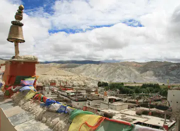
Upper Mustang occupies Nepal’s northernmost Himalayan borderland, a high, dry region carved by the Kali Gandaki and its tributary valleys. Sheltered from much of the summer monsoon by the Annapurna and Dhaulagiri ranges, it has a markedly Tibetan character: ochre cliffs, wind-shaped ridges, broad gravel terraces and irrigated fields appear beneath an often exceptionally clear sky. The area is commonly associated with the former Kingdom of Lo, whose historic capital, Lo Manthang, remains its cultural focus.Read more about Upper Mustang
Monasteries, Villages and Cave Country
A Restricted Cultural Landscape
When is the best time to visit Upper Mustang?
Best: May–June, September · 17–21°C| Month | High (°C) | Rainfall (mm) |
|---|---|---|
| January | 1 | 0 |
| February | 2 | 0 |
| March | 6 | 0 |
| April | 11 | 0 |
| May (best) | 17 | 6 |
| June (best) | 21 | 45 |
| July | 22 | 94 |
| August | 22 | 78 |
| September (best) | 18 | 34 |
| October | 10 | 6 |
| November | 7 | 0 |
| December | 1 | 0 |
Getting to and around Upper Mustang
How to get there
Transportation
Best attractions in Upper Mustang
Upper Mustang’s principal attraction is the journey through a high, eroded landscape where red, ochre and grey cliffs rise above the Kali Gandaki corridor. The route from Kagbeni leads through Chele, Syangboche, Ghami and Tsarang, each offering different views of dry valleys, cultivated terraces, chortens and whitewashed settlements. Lo Manthang is the cultural centre, with its compact historic townscape and important monasteries, while nearby Chhoser provides access to striking cliff country and cave sites. The village of Ghami is associated with a long mani wall, and Tsarang is known for its monastery and dramatic setting above the valley. Side valleys and high passes reveal a quieter landscape of grazing areas, ravines and remote hamlets. Attractions are dispersed rather than arranged as a conventional park, and exploration depends on the approved trekking itinerary, local access guidance, weather and the time allowed for acclimatisation.
-
Tour operator
Annapurna Base Camp Trek
Experience the breathtaking beauty of the Himalayas on the Annapurna Base Camp Trek, a perfect blend of adventure and culture in Nepal.
-
Tour operator
Muktinath Tour
Explore Muktinath, a sacred pilgrimage site in the Himalayas, where spirituality and stunning landscapes come together for an unforgettable experience.
-
Tourist attraction
Tilicho Lake View Point
Discover the breathtaking beauty of Tilicho Lake View Point, a must-visit destination in the Himalayas for stunning views and serene landscapes.
-
Tourist attraction
Lo Manthang Village
Experience the majestic charm of Lo Manthang Village, a cultural and natural treasure in the heart of Nepal's Mustang region, perfect for adventurous travelers.


Best landmarks in Upper Mustang
The walled town of Lo Manthang is Upper Mustang’s defining built landmark, with narrow lanes, traditional earthen houses and a group of important monasteries that express the former kingdom’s Tibetan Buddhist heritage. Tsarang’s monastery and hilltop setting mark another significant point along the historic route, while Ghami’s long mani wall reflects the continuing presence of religious practice in the landscape. Natural landmarks are equally prominent: the deeply cut Kali Gandaki valley, wind-eroded cliffs around Chhoser and the broad, barren plateaux give the region its distinctive form. The cave complexes around Chhoser are associated with ancient occupation and religious use, but individual sites may require local permission and careful access. These features are part of a living cultural landscape rather than a collection of isolated monuments.
-
Tourist attraction
Annapurna Conservation Area
Explore the breathtaking Annapurna Conservation Area, a UNESCO Biosphere Reserve, offering stunning treks, rich biodiversity, and vibrant local culture in Nepal.
-
Hindu temple
Shree Muktinath Temple
Experience the divine ambiance of Shree Muktinath Temple, a serene pilgrimage site surrounded by the majestic Himalayas, ideal for spiritual seekers and adventurers alike.
-
Tourist attraction
Tilicho Lake View Point
Experience the breathtaking beauty of Tilicho Lake View Point, a hidden gem in the Himalayas offering stunning vistas and unforgettable adventures.
-
Tourist attraction
Khicho Ice Lake
Explore the serene beauty of Khicho Ice Lake, a stunning Himalayan destination perfect for nature lovers and adventure seekers.


Explore Upper Mustang on the map
Plan your trip on one map. See where the top attractions, landmarks, restaurants and hotels are, and book hotels and experiences in a few clicks.
Best hotels in Upper Mustang
Best restaurants in Upper Mustang
Upper Mustang has a modest food culture shaped by altitude, Tibetan connections and the practical needs of trekking communities. Meals in teahouses and family-run lodges commonly draw on rice, noodles, lentils, vegetables, Tibetan-style breads and soups, while buckwheat, barley, potatoes and apples reflect local farming conditions. In the wider Mustang region, Thakali cooking adds another important culinary tradition, although the food available in the restricted area varies with supplies and season. Lo Manthang, Tsarang, Ghami and other larger villages provide the broadest choice of simple lodge meals, but remote stops may offer only a limited set menu. Visitors should not expect a restaurant district or extensive evening dining, and dietary requirements need to be explained in advance to the trekking agency and accommodation hosts.
-
Hotel
Hotel Mustang Gateway & Yac Donald's Restaurant
Discover unparalleled comfort and delicious dining at Hotel Mustang Gateway & Yac Donald's Restaurant in scenic Kagbeni, Nepal.
-
Restaurant
Mustang Lete Hotel & Thakali Kitchen
Discover authentic Thakali cuisine in Dana at Mustang Lete Hotel & Thakali Kitchen - where flavor meets breathtaking Himalayan views.
-
Restaurant
Chusang
Discover the flavors of Nepal at Chusang Restaurant—where authentic cuisine meets breathtaking landscapes in an unforgettable dining experience.
-
Restaurant
The Kailash Hotel, Tsarang, Mustang, Nepal
Discover authentic Nepali flavors at The Kailash Hotel in Tsarang, Mustang - A culinary journey amidst breathtaking Himalayan scenery.


Best bars in Upper Mustang
Upper Mustang has no conventional nightlife scene, and the high-altitude villages close early after the day’s trekking. Evening life is centred on teahouse dining rooms, quiet conversation with hosts and fellow walkers, and, when circumstances allow, glimpses of local religious or community activity. Lo Manthang and larger settlements may offer the greatest chance of informal socialising, but venues and operating arrangements are modest and seasonal rather than commercial. Alcohol may be available in some lodges, though supplies are limited and drinking is inappropriate in monasteries or during religious observances. Travellers should treat village evenings as a chance to rest, read, watch the changing light on the cliffs or learn about local customs rather than expecting bars, clubs or scheduled entertainment.
-
Restaurant
Cravend Restro and Bar
Experience the essence of Jomsom at Cravend Restro and Bar, where local flavors meet international cuisine in a stunning mountain setting.
-
Bar
KINGDOM RESTRO BAR & LIVE MUSIC (THAKALI BHANCHA GHAR)
Discover the heart of Jomsom's nightlife at Kingdom Restro Bar, where delicious cuisine meets live music and dance.
-
 Bar
Sunrise restaurant & BAR
Discover the vibrant flavors of Lo Manthang at Sunrise Restaurant & Bar, where local cuisine meets breathtaking views in a charming atmosphere.
-
Bar
धुम्बा ताल जोमसोम
Explore the tranquility of धुम्बा ताल in Jomsom, a serene lake surrounded by majestic mountains and rich local culture.


Best shops in Upper Mustang
Shopping in Upper Mustang is limited and practical, with opportunities concentrated in Lo Manthang, Kagbeni and other larger settlements rather than in dedicated retail areas. Small shops and lodge stores may carry snacks, basic supplies and trekking necessities, while local products can include woven textiles, woollen goods, religious items and handmade objects associated with Tibetan-influenced culture. Visitors should buy respectfully and avoid purchasing archaeological material, old religious objects or anything that may have been removed from a monastery or cave site. Apples and other agricultural products are associated with Mustang more broadly, although availability varies by season and location. Larger selections of equipment, medicines and general supplies are found in Pokhara or Jomsom, so Upper Mustang should not be treated as a destination for extensive shopping.
-
Tourist attraction
Shree Muktinath Temple
Experience spiritual bliss at Shree Muktinath Temple, a sacred site for pilgrims amidst the majestic Himalayas.
-
Tourist attraction
Kagbeni mustang
Explore Kagbeni, a hidden gem in the Mustang region, where ancient culture meets breathtaking Himalayan landscapes.
-
Tourist attraction
Upper Mustang, Nepal
Experience the enchanting beauty and rich Tibetan culture of Upper Mustang, Nepal, a hidden gem in the heart of the Himalayas.
-
Coffee shop
Himalayan Java Gallery Cafe
Experience the perfect blend of coffee, art, and live music at Himalayan Java Gallery Cafe in Jomsom, Mustang.


Get your free copy of our complete guide to Upper Mustang, delivered straight to you.
Everything on this page, from attractions and restaurants to essentials and local phrases, in one PDF you can read offline, print or share.
Already have an account? Sign in
Your Upper Mustang guide is ready.
We'll send it to · Not you? Sign out

Getting your guide ready…
We are putting together a fresh copy of the Upper Mustang guide. This can take up to a minute.
This can take a few moments. If your browser asks, choose Allow so the download can start. You'll find the guide in your Downloads folder.
Nothing happened? Download it again
Sorry, the guide is taking longer than usual. Please try again in a minute, or get it by email instead.
Upper Mustang essentials
Currency and Payment
Safety
Emergency Situations
Do's and Don'ts
Local Tips
From Eve
Local phrases worth knowing
You don't need to get them perfect. A few words go a long way, and locals appreciate the effort.
Basics
| English | Local | Say it |
|---|---|---|
| Hello | नमस्ते | [namaste] |
| Goodbye | फेरि भेटौं | [pheri bhetou] |
| Yes | हो | [ho] |
| No | होइन | [hoin] |
| Please/You're welcome | कृपया | [kripaya] |
| Thank you | धन्यवाद | [dhanyabad] |
| Excuse me/Sorry | माफ गर्नुहोस् | [maaf garnuhos] |
| How are you? | तपाईंलाई कस्तो छ? | [tapailai kasto cha?] |
| Fine. And you? | राम्रो छ। तिमीलाई? | [ramro cha. timilai?] |
| Do you speak English? | तिमी अंग्रेजी बोल्छौ? | [timi angreji bolchhau?] |
| I don't understand | मैले सम्झिन | [maile samjhin] |
Eating & Drinking
| English | Local | Say it |
|---|---|---|
| I'd like to see the menu, please | कृपया मेनु हेर्न लागि | [kripaya menu hern lagi] |
| I don't eat meat | म भांसाखान्छु | [ma bhansakhanchu] |
| Cheers! | चियर्स! | [chears!] |
| I would like to pay, please | कृपया तिर्न चाहन्छु | [kripaya tirn chahanchu] |
Emergencies
| English | Local | Say it |
|---|---|---|
| Help! | मदत! | [madat!] |
| Go away! | दुर्गम! | [durgam!] |
| Call the Police! | प्रहरीलाई बोलाउनुहोस्! | [praharilai bolaunuhos!] |
| Call a doctor! | डाक्टरलाई बोलाउनुहोस्! | [daktarlai bolaunuhos!] |
| I'm lost | म हराएको छु | [ma haraeko chu] |
| I'm ill | म रोगी छु | [ma rogi chu] |
Shopping
| English | Local | Say it |
|---|---|---|
| I'd like to buy... | म किन्न चाहन्छु | [ma kinn chahanchu] |
| I'm just looking | म सिर्जना गरिरहेको छु | [ma sirjana gariraheko chu] |
| How much is it? | यो कति हो? | [yo kati ho?] |
| That's too expensive | यो धेरै महँगो छ | [yo dherai mahango cha] |
| Can you lower the price? | के तपाईं मूल्य हाल्न सक्नुहुन्छ? | [ke tapailai mulya haln saknuhunchha?] |
Time & Numbers
| English | Local | Say it |
|---|---|---|
| What time is it? | कति बज्यो? | [kati bajyo?] |
| It's one o'clock | एक बजे भएको छ | [ek baje bhaeko cha] |
| Half past (10) | दसबजे डेढ | [dasbaje dedh] |
| Morning | बिहान | [bihan] |
| Afternoon | दिउँसो | [diunso] |
| Evening | साँझ | [sanh] |
| Yesterday | हिजो | [hijo] |
| Today | आज | [aaj] |
| Tomorrow | भोली | [bholi] |
| 1 | एक | [ek] |
| 2 | दुई | [dui] |
| 3 | तीन | [tin] |
| 4 | चार | [char] |
| 5 | पाँच | [paanch] |
| 6 | छ | [chh] |
| 7 | सात | [saat] |
| 8 | आठ | [aath] |
| 9 | नौ | [nau] |
| 10 | दस | [das] |
Transport & Directions
| English | Local | Say it |
|---|---|---|
| Where's a/the...? | यहाँ कुनै... कहाँ छ? | [yaha kunai... kaha cha?] |
| What's the address? | ठेगाना के हो? | [thegana ke ho?] |
| Can you show me (on the map)? | के तपाईं म प्रदर्शन गर्न सक्नुहुन्छ (नक्सामा)? | [ke tapailai pradarshan garn saknuhunchha (naksama)?] |
| When's the next (bus)? | अर्को कति बज्यो (बस)? | [arko kati bajyo (bas)?] |
| A ticket (to ....) | एक कोटी (मा ....) | [ek koti (ma ....)] |
History of Upper Mustang
A River-Cut Himalayan Frontier
Upper Mustang’s physical setting was formed over immense geological timescales as the Kali Gandaki and other rivers cut through uplifted Himalayan terrain. The region lies in the rain shadow of the main Himalayan ranges, producing an arid landscape of sedimentary cliffs, eroded ravines and high plateaux rather than the wetter forests associated with southern Nepal. These natural conditions shaped settlement: communities concentrated around springs, river terraces and cultivable pockets where irrigation could support barley, buckwheat, wheat and fruit. The area’s position between the Tibetan Plateau and the middle hills also made its valleys long-standing corridors for movement, exchange and cultural contact.
Communities of the Kingdom of Lo
The settlements of Upper Mustang developed within a Tibetan-influenced cultural world whose language, religious traditions, architecture and agricultural practices remain visible today. Local society was organised around villages, monasteries and the authority of the ruler of Lo, with fortified houses and walled settlements reflecting the need to protect communities in an exposed frontier environment. Lo Manthang became the political and cultural centre of the kingdom, while smaller settlements such as Tsarang, Ghami and Chhoser retained their own religious and agricultural identities. Trade, pastoralism and cultivation were closely connected to the difficult but strategically important trans-Himalayan landscape.
Incorporation into Nepal
The Kingdom of Lo became linked to the expanding Nepali state during the late eighteenth century, while retaining a degree of local autonomy and its own hereditary ruling tradition. This relationship helped preserve a distinct regional identity within Nepal rather than erasing the area’s Tibetan cultural connections. For centuries, the Kali Gandaki corridor also remained associated with trade and seasonal movement across the Himalaya, although political borders and changing conditions gradually altered those patterns. The people of Upper Mustang continued to maintain monasteries, village institutions and agricultural systems adapted to the high desert.
A Closed Borderland Opens Carefully
For much of the modern period, Upper Mustang was a tightly controlled border region, with limited access for foreign visitors because of its proximity to Tibet and its political sensitivity. Restricted tourism began in 1992, allowing carefully managed trekking while limiting numbers and requiring special permits and authorised arrangements. This gradual opening helped generate income for local communities but also placed pressure on fragile landscapes, historic buildings and archaeological sites. The area’s cultural value, rather than only its scenery, became central to its tourism identity.
The End of the Mustang Monarchy
Nepal became a federal democratic republic in 2008, and the ceremonial monarchy of Mustang ceased to have an official governing role. The former royal city of Lo Manthang nevertheless remains an important cultural centre, and the title and memory of the Mustang king continue to carry local and historical significance. Contemporary Upper Mustang balances road construction, changing livelihoods, conservation concerns and tourism development. Ancient monasteries, traditional houses and cave sites remain vulnerable to weather, alteration and neglect, while local communities continue to sustain religious festivals, farming practices and forms of architecture that give the region its character.
Upper Mustang in Photos
Browse through our photo collection highlighting the charm and character of the destination.
Neighbouring destination travel guides
The closest destinations to Upper Mustang, if you have time for more than one.
-

-
-

-

-


Swipe for more destinations
Explore more

Explore more of Dhaulagiri Zone
Explore Dhaulagiri Zone in Nepal for high Himalayan trails, Mustang villages, Kali Gandaki scenery, mountain culture and adventurous trekking.
Explore Dhaulagiri Zone
Explore more of Nepal
Discover Nepal: A land of towering peaks, spiritual harmony, and vibrant culture, offering endless adventures and serene escapes for every traveler.
Explore Nepal