Background

Kammerslusen Clay Excavations

Freshwater lakes and wetlands where industrial heritage meets thriving birdwatching paradise.

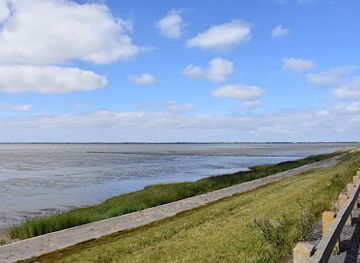
Kammerslusen Clay Excavations is a distinctive coastal landscape near Ribe featuring freshwater lakes formed by historical clay extraction. Surrounded by agricultural fields and grasslands, the site offers excellent birdwatching opportunities with seasonal populations of waders and ducks. The excavated terrain creates a unique wetland environment that contrasts with the surrounding Wadden Sea region, making it a compelling destination for nature enthusiasts and ornithologists.

A brief summary to Kammerslusen Clay Excavations

  • Ribe, 6760, DK
  • Visit website
  • Duration: 1 to 3 hours
  • Free
  • Environment icon Outdoor
  • Mobile reception: 4 out of 5

Local tips

  • Visit during spring (April–May) or autumn (August–September) migration periods for peak birdwatching opportunities when thousands of waders and ducks congregate at the site.
  • Bring binoculars and a field guide to bird species; the varying water levels expose mudflats that attract specialized wader species difficult to observe elsewhere.
  • Combine your visit with exploration of medieval Ribe town center, located just a few kilometers away, to experience Denmark's oldest settlement and its rich cultural heritage.
  • Early morning visits offer the best wildlife observation, with reduced human disturbance and optimal lighting for photography and bird identification.
  • Wear waterproof footwear and weather-appropriate clothing; the exposed terrain offers limited shelter, and conditions change rapidly with wind and precipitation.
widget icon

Getting There

  • Car from Ribe town center

    Drive approximately 5–7 kilometers south from Ribe's medieval town center toward the Wadden Sea coast. Follow signs toward the Kammerslusen lock and dam area. Travel time is approximately 10–15 minutes. Parking is available near the lock structure and dam access points. No entrance fee required. The route is accessible year-round, though winter weather may affect road conditions.

  • Bicycle from Ribe

    Cycle south from Ribe town center along regional cycling routes toward the Wadden Sea coast, approximately 5–7 kilometers. The journey takes 20–30 minutes on relatively flat terrain typical of the region. Dedicated cycling paths and rural roads provide safe passage. Bicycle parking is available at the dam and lock area. This option is weather-dependent and most practical during mild seasons.

  • Walking from Kammerslusen lock

    If arriving at the Kammerslusen lock and dam structure, the clay excavations are accessible via walking paths and elevated vantage points adjacent to the lock. The terrain is relatively flat and open, with viewing areas positioned to overlook the water bodies. Walking duration depends on the extent of exploration, typically 30 minutes to 2 hours for comprehensive site observation.

  • Bus from Ribe

    Regional bus services operate from Ribe town center toward the Wadden Sea coast and surrounding communities. Journey times vary by route and service frequency, typically 20–40 minutes depending on stops. Schedules are seasonal and less frequent during winter months. Confirm current routes and timetables locally, as service patterns may change. No dedicated bus stop exists directly at the excavations; nearest stops are near the Kammerslusen lock area.

Kammerslusen Clay Excavations location weather suitability

  • Weather icon Any Weather
  • Weather icon Clear Skies
  • Weather icon Cold Weather
  • Weather icon Mild Temperatures

Unlock the Best of Kammerslusen Clay Excavations

Buy tickets

    No tickets available

Book tours with entry

    No tours available

Book tours without entry

    No tours available

Discover more about Kammerslusen Clay Excavations

A Landscape Shaped by Industry and Nature

Kammerslusen Clay Excavations represents a fascinating intersection of human industrial activity and natural ecological recovery. The site comprises a series of coastal freshwater lakes created through historical clay extraction operations, now transformed into a thriving wetland habitat. The varying water levels across the excavated basins create dynamic conditions that support diverse wildlife, particularly migratory and resident bird species. The surrounding agricultural landscape and grasslands frame these water bodies, creating a mosaic of habitats that sustains rich biodiversity throughout the year.

Premier Birdwatching Destination

The clay excavations have become renowned among ornithologists and birdwatchers for their exceptional populations of waders and ducks. The freshwater lakes attract numerous species during migration periods, while year-round residents utilize the site for feeding and breeding. The varying water depths and exposed mudflats created by fluctuating water levels provide ideal foraging grounds for specialized wader species. Birdwatchers visiting during spring and autumn migrations often encounter significant concentrations of birds, making the site a critical stopover point along major migratory routes.

Ecological Significance Within the Wadden Sea Region

Kammerslusen occupies an important ecological niche within the broader Wadden Sea UNESCO World Heritage area. While the Wadden Sea itself represents a unique tidal flat and barrier island system of global significance, the clay excavations provide complementary freshwater habitats that support species requiring different environmental conditions. The site's proximity to the Wadden Sea coast creates a transition zone where freshwater and brackish influences interact, enhancing overall habitat diversity. This ecological complementarity makes the excavations an integral component of the region's conservation value.

Seasonal Dynamics and Water Management

The character of Kammerslusen shifts dramatically with the seasons, driven by natural precipitation patterns and managed water levels. Winter months bring increased water volumes and attract dabbling ducks and diving species seeking open water. Spring and autumn migrations transform the site into a bustling waystation where thousands of birds pause to refuel during their long journeys. Summer conditions expose more mudflat areas, creating prime feeding habitat for waders. The managed nature of water levels reflects the site's history as an industrial extraction area, with ongoing stewardship balancing recreational, ecological, and agricultural interests.

Access and Visitor Experience

The excavations remain largely undeveloped, preserving their natural character while offering accessible viewing opportunities from surrounding paths and elevated vantage points. Visitors can observe the landscape from the adjacent dam and elevated areas, providing clear sightlines across the water bodies and surrounding terrain. The site's integration within the broader Ribe region, Denmark's best-preserved medieval town, allows visitors to combine natural history exploration with cultural and historical discovery. The contrast between the industrial-turned-natural landscape and the medieval architecture of nearby Ribe creates a compelling juxtaposition of temporal scales.

Busiest months of the year

Busiest hours of the day

Popular Experiences near Kammerslusen Clay Excavations

Popular Hotels near Kammerslusen Clay Excavations

Select Currency