Background

Isbjerg – Highest Point of Nationalpark Thy

A low Danish hill with a vast horizon, Isbjerg crowns Thy National Park with sweeping dune-heath views, ancient coastlines, and a quiet sense of wilderness.

★★★★★4.6 (141)

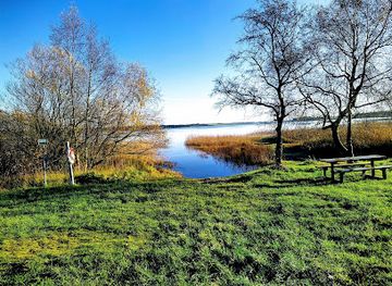
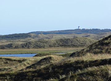
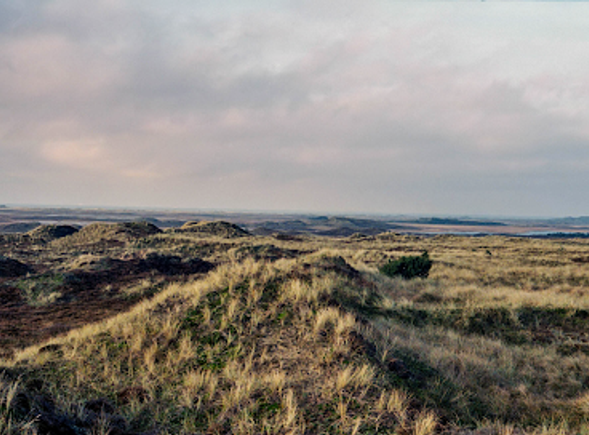
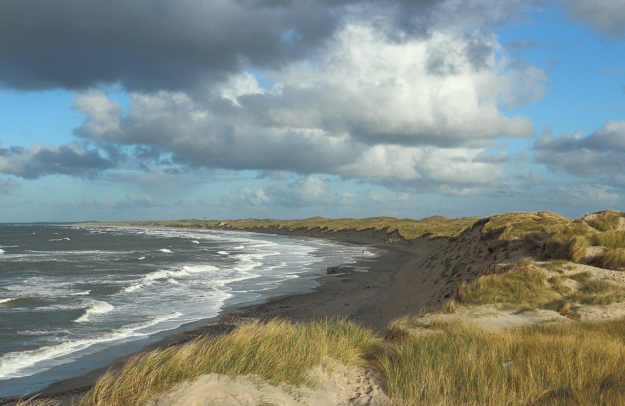
Rising a modest 56 meters above sea level, Isbjerg is the highest point in Thy National Park and the Hanstholm Wildlife Reserve, yet the views feel almost alpine in scale. From this heath-covered hill near Nors Lake, you look out across an immense mosaic of dunes, moorland, lakes, and plantations that once lay on the seabed. A well-marked trail climbs the old Stone Age coastal slope to a Bronze Age burial mound at the summit, where red deer, cranes, and sea eagles share the horizon. It is a compact, family-friendly walk into one of Denmark’s wildest landscapes.

Plan your visit

A brief summary to Isbjerg - Nationalpark Thy

Opening times, essentials, and a few local tips gathered into one calmer, easier-to-scan planning section.

Plan your visit

📍
Hindingvej 45, Thisted, 7700, DK
🕒
Duration: 1 to 3 hours
💷
Free
🏛
Outdoor
📶
Mobile reception: 3 out of 5

Explore places near Isbjerg - Nationalpark Thy

    See all →

    Unlock the Best of Isbjerg - Nationalpark Thy

    Find tickets, tours with entry, and experiences available for this location.

    Buy tickets

    No tickets available

    Book tours with entry

    No tours with entry available

    Book tours without entry

    No tours without entry available

    Getting There

    Car from Thisted

    From central Thisted, driving to the Isbjerg parking area near Hindingvej typically takes 20–30 minutes, depending on traffic and weather. The route follows regional roads through open countryside and is straightforward, but the final approach along Hindingvej is narrow with limited passing points. Parking at the trailhead is free and usually sufficient outside peak summer weekends. There are no fuel or food outlets immediately by the car park, so plan to arrive with what you need.

    Bicycle from Thisted area

    Cyclists can reach the Isbjerg trailhead from Thisted or Nors in about 45–70 minutes, using local roads that pass through gently undulating farmland and forest edges. The ride involves some exposure to wind and occasional fast-moving traffic, so high-visibility clothing and lights are advisable. There is no dedicated bike parking infrastructure at the car park, but bikes can be locked to natural features or laid off to the side without blocking access.

    Regional bus plus walk

    Regional buses connect Thisted with nearby villages such as Nors in roughly 15–25 minutes, with typical fares in the range of 20–40 DKK one way within the local zone system. From a stop in or near Nors, you should allow 45–60 minutes of walking on mixed-surface minor roads and paths to reach the Isbjerg parking area. Services run less frequently in the evenings and on weekends, so checking the timetable in advance is essential.

    For the on-the-go comforts that matter to you

    Restrooms
    Seating Areas
    Picnic Areas
    Trash Bins
    Information Boards

    Local tips

    Wear sturdy, closed shoes; the sandy, uneven trail up the old coastal slope can be slippery in wet or windy weather.
    Bring binoculars to improve your chances of spotting red deer on the heath and white-tailed eagles soaring above the reserve.
    Check seasonal access rules for Hanstholm Wildlife Reserve, especially in spring and early summer when breeding birds are protected.
    Pack a windproof layer even in summer; the exposed summit often feels cooler and breezier than the trailhead.
    Download the Thy National Park app or an offline map before you go, as mobile reception can vary around the lakes and heath.

    Isbjerg - Nationalpark Thy location weather suitability

    Catch the right light and the right mood, whether you want a bright city moment or a more cinematic evening visit.

    Weather icon
    Clear Skies
    Weather icon
    Mild Temperatures
    Weather icon
    Windy Conditions
    Weather icon
    Hot Weather
    Weather icon
    Cold Weather
    Weather icon
    Any Weather

    Discover more about Isbjerg - Nationalpark Thy

    From Modest Hill to Immense Horizon

    Isbjerg may stand only 56 meters above sea level, but in flat, wind-shaped Northwest Jutland it feels like a true summit. As the highest point in Thy National Park and the Hanstholm Wildlife Reserve, it offers a sweeping panorama across the park’s northern reaches, from the North Sea and Hanstholm in the distance to Tved Klitplantage in the east and the lake of Nors Sø and Vilsbøl Plantage to the south. From the top, the landscape unfolds as a patchwork of heather-clad dunes, pale sand, dark plantations, and glittering wetlands. On clear days the horizon seems to stretch endlessly, conveying the scale of Denmark’s first national park in a single slowly turning glance.

    A Stone Age Coastline Beneath Your Feet

    The approach to Isbjerg follows the line of an ancient shore. In the Stone Age, the heathland you see today lay under the sea, while Isbjerg rose as part of an island and Nors Sø formed a sheltered bay. As you climb, you are effectively walking up the steep slope of that former coastline, now preserved as a fossil cliff line running through the national park. Most of the surrounding reserve sits on this former seabed, a mix of dune ridges, low bogs, and shallow lakes. Between hummocks of heather and coarse grass, the ground is often wet and patterned with small pools, creating ideal conditions for rare plants and countless insect species that thrive in these nutrient-poor, wind-exposed habitats.

    Wildlife Sanctuary in the Dune Heath

    Hanstholm Wildlife Reserve, with its roughly 3,900 hectares of protected dune heath and wetlands, is managed first and foremost for animals and birds. Restrictions on access in core areas, especially during spring and early summer, keep large tracts undisturbed and quiet, turning the reserve into a genuine refuge. From Isbjerg, patient observers may spot large herds of red deer grazing on distant slopes, moving like slow shadows across the heath. Overhead, there is a chance of seeing white-tailed eagles and ospreys circling high, while waders such as cranes and other breeding birds use the marshes and lakes that dot the former seabed below.

    The Story Behind the Name and the Burial Mound

    Despite its literal translation as "Ice Mountain," the name Isbjerg is more closely linked to trees than to frozen seas. One explanation traces it back to the Iron Age, when the yew tree, considered sacred, was associated with a word resembling "I-tree." Yews once grew in the area around the hill, and over time that association shaped the name and its pronunciation. At the summit you will find a Bronze Age burial mound, a low, rounded rise that crowns the hill and adds a quiet human presence to the wild surroundings. It stands as a reminder that this landscape, though it feels remote and untamed, has been significant to people for millennia, both spiritually and strategically.

    Walking the Edge of the Reserve

    The main marked trail to Isbjerg runs from the Nors Sø area along the very edge of the wildlife reserve, rising steadily but without technical difficulty. Underfoot, the path alternates between sandy stretches and softer heath soil, with occasional roots and uneven patches where erosion has bitten into the old coastal slope. Because the route traces the reserve boundary, visitors are asked to stay on the marked trail and respect seasonal closures in adjacent zones to safeguard breeding birds and sensitive wetlands. The combination of easy access, waymarking, and nearby facilities makes the walk suitable for most reasonably mobile visitors, including families looking for a short but memorable outing.

    Moments of Quiet on the Windy Summit

    At the top of Isbjerg, the character of the place is shaped by sound as much as by sight. The wind often dominates, rushing through heather and low shrubs, carrying the distant roar of the North Sea on blustery days and soft birdsong on calmer ones. Even a brief pause here can feel like stepping out of everyday time and into a slower, more elemental rhythm. Simple wayfinding signs, a nearby toilet at the parking area, and informal spots to sit in the grass encourage unhurried contemplation rather than structured activity. Many visitors choose to linger, watching the clouds move over the heath or tracing the line where ancient sea once met land, before descending the same path back toward the lakes and plantations below.

    Plan around the quieter times

    A quick look at seasonal patterns and peak visiting hours.

    Busiest months of the year

    Seasonality

    Busiest hours of the day

    Footfall
    Mobile App
    Get the app

    Your all‑in‑one travel companion app

    Explore expert travel guides, compare and book tours, experiences, hotels, and more—all from the palm of your hand. Download now for seamless trip planning wherever your wanderlust takes you.

    File:Nørre Vorupør Coast 2012-11-18.jpg - Wikimedia Commons

    More about Thy National Park

    Discover Thy National Park, Denmark's first national park, a coastal wilderness offering diverse landscapes, rich wildlife, and countless outdoor activities for nature lovers.

    Tell me more about Thy National Park

    Select Currency

    Choose the currency you want prices to display in.