

Alps Travel Guide - Free Web & App
Your ultimate guide to Alps. Discover top landmarks, proposed trips, and local tips. Free on the web or via the Evendo companion app.


German Alps travel guide: explore Zugspitze, Bavarian lakes, alpine villages, castles, hiking trails, winter sports and heritage across southern Bavaria.
Mountain Landscapes and Regional Character
The German Alps form the northern edge of the Alpine arc in Bavaria, stretching from the Allgäu and Lake Constance region eastwards through the Ammergau, Wetterstein, Chiemgau and Berchtesgaden Alps. This is not one enclosed park but a broad mountain region of limestone ridges, wooded foothills, green valleys, high pastures, glacial lakes and settlements shaped by centuries of farming and trade. Germany’s highest mountain, the Zugspitze, rises above Garmisch-Partenkirchen, while the dramatic peaks and rock faces around Berchtesgaden give the far east a more rugged character.Read more about Alps
Villages, Lakes and Cultural Heritage
Outdoor Experiences and Protected Landscapes
When is the best time to visit Alps?
Best: June–August · 23–25°C| Month | High (°C) | Rainfall (mm) |
|---|---|---|
| January | 1 | 50 |
| February | 2 | 40 |
| March | 7 | 40 |
| April | 13 | 30 |
| May | 18 | 30 |
| June (best) | 23 | 30 |
| July (best) | 25 | 30 |
| August (best) | 24 | 30 |
| September | 20 | 40 |
| October | 14 | 50 |
| November | 9 | 50 |
| December | 4 | 50 |
Getting to and around Alps
How to get there
Transportation
Best attractions in Alps
-
Tourist attraction
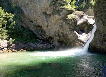
Buchenegger Wasserfälle
Immerse yourself in nature at Buchenegger Wasserfälle, where breathtaking waterfalls and lush trails create unforgettable experiences in the Bavarian Alps.
Explore Alps on the map
Plan your trip on one map. See where the top attractions, landmarks, restaurants and hotels are, and book hotels and experiences in a few clicks.
Best hotels in Alps
Get your free copy of our complete guide to Alps, delivered straight to you.
Everything on this page, from attractions and restaurants to essentials and local phrases, in one PDF you can read offline, print or share.
Already have an account? Sign in
Your Alps guide is ready.
We'll send it to · Not you? Sign out

Getting your guide ready…
We are putting together a fresh copy of the Alps guide. This can take up to a minute.
This can take a few moments. If your browser asks, choose Allow so the download can start. You'll find the guide in your Downloads folder.
Nothing happened? Download it again
Sorry, the guide is taking longer than usual. Please try again in a minute, or get it by email instead.
Alps essentials
Currency and Payment
Safety
Emergency Situations
Do's and Don'ts
Local Tips
From Eve
Local phrases worth knowing
You don't need to get them perfect. A few words go a long way, and locals appreciate the effort.
Basics
| English | Local | Say it |
|---|---|---|
| Hello | Griaß God | [gree-ahss god] |
| Goodbye | Pfiat di | [pfee-aht dee] |
| Yes | Ja | [yah] |
| No | Nein | [nine] |
| Please/You're welcome | Bitte | [bit-teh] |
| Thank you | Danke | [dahn-keh] |
| Excuse me/Sorry | Entschuldigung | [ent-shool-dee-goong] |
| How are you? | Wie geht's? | [vee gayts] |
| Fine. And you? | Gut. Und dir? | [goot oond deer] |
| Do you speak English? | Sprichst du Englisch? | [shpree-khst doo eng-leesh] |
| I don't understand | Ich verstehe nicht | [ikh fehr-shteh-eh neekt] |
Eating & Drinking
| English | Local | Say it |
|---|---|---|
| I'd like to see the menu, please | Ich möchte bitte die Speisekarte sehen | [ikh merkhte bit-teh dee shpy-suh-kahr-teh zay-en] |
| I don't eat meat | Ich esse kein Fleisch | [ikh ess-eh kine flysh] |
| Cheers! | Prost! | [prohst] |
| I would like to pay, please | Ich möchte bitte zahlen | [ikh merkhte bit-teh tsah-len] |
Emergencies
| English | Local | Say it |
|---|---|---|
| Help! | Hilfe! | [hil-feh] |
| Go away! | Geh weg! | [gay vehg] |
| Call the Police! | Rufen Sie die Polizei! | [roo-fen zee dee poh-lee-tsye] |
| Call a doctor! | Rufen Sie einen Arzt! | [roo-fen zee ayn-en ahrts] |
| I'm lost | Ich habe mich verirrt | [ikh hah-buh meekh feh-reert] |
| I'm ill | Mir ist schlecht | [meer ist shleht] |
Shopping
| English | Local | Say it |
|---|---|---|
| I'd like to buy... | Ich möchte kaufen... | [ikh merkhte kow-fen] |
| I'm just looking | Ich schaue nur | [ikh shou-eh noor] |
| How much is it? | Wie viel kostet es? | [vee feel kaws-tet es] |
| That's too expensive | Das ist zu teuer | [dahs ist tsoo toy-er] |
| Can you lower the price? | Können Sie den Preis senken? | [ker-nen zee den prees zeng-ken] |
Time & Numbers
| English | Local | Say it |
|---|---|---|
| What time is it? | Wie spät ist es? | [vee shpayt ist es] |
| It's one o'clock | Es ist ein Uhr | [es ist iyn oor] |
| Half past (10) | Halb (zehn) | [halb (tsayn)] |
| Morning | Morgen | [mohr-ghen] |
| Afternoon | Nachmittag | [nahkh-mit-tahk] |
| Evening | Abend | [ah-bent] |
| Yesterday | Gestern | [geh-stern] |
| Today | Heute | [hoy-teh] |
| Tomorrow | Morgen | [mohr-ghen] |
| 1 | Eins | [ayns] |
| 2 | Zwei | [tsvay] |
| 3 | Drei | [dry] |
| 4 | Vier | [feer] |
| 5 | Fünf | [fuenf] |
| 6 | Sechs | [zeks] |
| 7 | Sieben | [zee-ben] |
| 8 | Acht | [ahkht] |
| 9 | Neun | [noyn] |
| 10 | Zehn | [tsayn] |
Transport & Directions
| English | Local | Say it |
|---|---|---|
| Where's a/the...? | Wo ist ein/der...? | [vo ist iyn/dehr] |
| What's the address? | Was ist die Adresse? | [vas ist dee ah-drehs-seh] |
| Can you show me (on the map)? | Kannst du mir zeigen (auf der Karte)? | [kanst doo meer tsay-gen (owf dehr kahr-teh)] |
| When's the next (bus)? | Wann kommt der nächste (Bus)? | [vahn kohmt dehr naykhs-teh (boos)] |
| A ticket (to ....) | Eine Fahrkarte (nach ....) | [iyn-eh fahr-kahr-teh (nahkh)] |
History of Alps
Glacial Formation and Alpine Landscapes
The German Alps were shaped over immense geological timescales by the collision of the African and European tectonic plates, which folded and lifted marine sediments into the Alpine ranges. Later glaciations carved valleys, deposited moraines and left the lakes and rounded foothills characteristic of the Bavarian Alpine Foreland. Limestone dominates many of the region’s principal massifs, including the Wetterstein and Berchtesgaden Alps, producing cliffs, karst features and pale rock faces. These geological processes explain the contrast between broad lake country in the north and sharply defined mountain groups farther south, while also influencing settlement, pasture, forestry and the routes used through the valleys.
Early Settlement and Alpine Farming
People have used the Bavarian Alpine region since prehistoric times, although its terrain encouraged settlement to concentrate in valleys, foothills and lake margins. Celtic communities preceded Roman rule, and Roman roads connected the Alpine provinces with settlements north of the mountains. After the Roman period, Bavarian-speaking communities developed farming systems adapted to steep ground and short growing seasons. Hay meadows, summer pastures and seasonal cattle movement created the cultural landscape still visible around many villages. Churches, farmhouses and pilgrimage routes record the growing influence of Christianity during the medieval period, while local communities remained closely dependent on timber, livestock, salt and limited valley agriculture.
Salt, Trade and Territorial Powers
Salt was one of the most important historic resources in the eastern German Alps. Brine springs and deposits around Berchtesgaden and Bad Reichenhall supported extraction, processing and trade, giving local rulers considerable economic influence. Routes across the valleys also linked Bavaria with Tyrol, Salzburg and the wider Alpine world, carrying livestock, timber, salt and other goods. Monasteries and ecclesiastical estates shaped settlement and land management, while castles and fortified sites reflected the interests of regional powers. In the western Bavarian Alps, towns such as Füssen developed through their position on routes crossing the foothills and connecting north-south trade.
Royal Landscapes and Early Tourism
The nineteenth century brought a new cultural interest in mountain scenery, aided by improved roads, railways and the growth of Alpine clubs. Bavarian King Ludwig II transformed the landscape around Hohenschwangau and Neuschwanstein through his romantic palace projects, while artists, writers and mountaineers increasingly visited the region. Railway connections helped Garmisch-Partenkirchen, Oberstdorf, Berchtesgaden and other settlements develop as health, excursion and climbing destinations. Alpine guides, mountain huts and mapped routes made higher terrain more accessible, although tourism remained closely interwoven with farming and local craft traditions.
Conservation and Modern Alpine Use
Twentieth-century tourism expanded rapidly through skiing, cable cars, lakeside holidays and road travel, particularly around Garmisch-Partenkirchen and the eastern Bavarian Alps. The same period brought growing concern about traffic, development, erosion and habitat loss. Berchtesgaden National Park, established in 1978, became Germany’s only national park in the Alps and placed landscape protection at the centre of regional management. Today the mountains accommodate recreation, agriculture, forestry and tourism alongside conservation. Visitor pressure is managed through marked routes, protected habitats and public transport initiatives, while debates about climate change, snow reliability, water resources and the future of alpine farming continue to shape the region.
Alps in Photos
Browse through our photo collection highlighting the charm and character of the destination.
Neighbouring destination travel guides
The closest destinations to Alps, if you have time for more than one.
-

-

-
-

-


Swipe for more destinations
Explore more

Explore more of Lower Rhine
Explore the Lower Rhine: A scenic journey through Germany's lush landscapes, historic treasures, and culinary delights.
Explore Lower Rhine
Explore more of Germany
Experience Germany: where history meets innovation, and urban energy blends with natural beauty. Discover diverse cultures, delicious cuisine, and stunning landscapes.
Explore Germany