

Shawnee National Forest Travel Guide - Free Web & App
Your ultimate guide to Shawnee National Forest. Discover top landmarks, proposed trips, and local tips. Free on the web or via the Evendo companion app.


Shawnee National Forest in Illinois offers Garden of the Gods, forest trails, waterfalls, river bluffs, wildlife and outdoor adventure in southern USA.
Forests, Bluffs and River Country
Stretching across roughly 280,000 acres in southern Illinois, Shawnee National Forest is a broad, varied landscape rather than a single compact park. Its public lands extend between the Mississippi and Ohio rivers, incorporating hardwood forest, sandstone escarpments, secluded hollows, open grassland, lakes and wetlands. The forest is divided into eastern and western sections by the lower Ohio River valley, with towns such as Harrisburg, Vienna, Marion, Golconda and Carbondale providing practical bases for different areas.Read more about Shawnee National Forest
The Garden of the Gods and Beyond
A Landscape Shaped by People
When is the best time to visit Shawnee National Forest?
Best: May, September–October · 22–28°C| Month | High (°C) | Rainfall (mm) |
|---|---|---|
| January | 6 | 90 |
| February | 8 | 80 |
| March | 15 | 100 |
| April | 21 | 110 |
| May (best) | 26 | 120 |
| June | 31 | 100 |
| July | 33 | 100 |
| August | 32 | 100 |
| September (best) | 28 | 90 |
| October (best) | 22 | 90 |
| November | 14 | 100 |
| December | 8 | 100 |
Getting to and around Shawnee National Forest
How to get there
Transportation
Best attractions in Shawnee National Forest
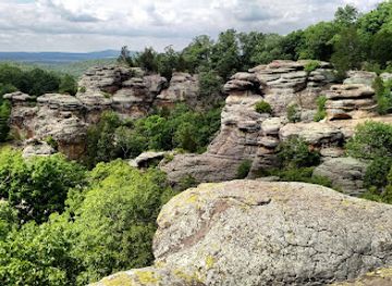
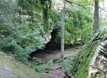
Garden of the Gods Recreation Area is Shawnee's signature attraction, with the short Observation Trail leading to elevated views over forested ridges and distinctive sandstone formations; the longer Indian Point Trail offers a different perspective on the same geological country. Nearby Rim Rock National Recreation Trail passes through a narrow sandstone corridor and wooded ravines, while Pounds Hollow Lake provides a forest-framed setting for recreation. In the western section, Bell Smith Springs combines clear spring-fed water, rock shelves and hiking routes, and Burden Falls is a seasonal highlight reached through rugged terrain. Jackson Falls is known for its sandstone cliffs and climbing culture, although visitors should follow current access guidance. Lusk Creek Canyon offers a more secluded landscape of bluffs, streams and woodland trails. Cave-in-Rock State Park and the Ohio River are nearby attractions reached from the forest's eastern side, but they are separate from the national forest itself.
-
Tourist attraction
Garden of the Gods
Explore the breathtaking rock formations and stunning vistas at the Garden of the Gods, a must-visit natural wonder in southern Illinois.
-
State park
Giant City State Park
Discover the breathtaking beauty of Giant City State Park, a haven for outdoor adventure and serene natural landscapes in Illinois.
-
State park
Cave-In-Rock State Park
Explore the captivating landscapes and rich history of Cave-In-Rock State Park, a must-visit destination for nature lovers and adventure seekers in Illinois.
-
Park
Bell Smith Springs Scenic Area
Discover the breathtaking landscapes and unique geological formations of Bell Smith Springs Scenic Area in Ozark, Illinois, a hidden gem for nature lovers.

Best landmarks in Shawnee National Forest
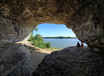
The most recognisable natural landmark in Shawnee National Forest is the sandstone formation known as Camel Rock at Garden of the Gods, part of a wider ridge of weathered rock towers and escarpments overlooking the forest. The Garden of the Gods Observation Trail and Rim Rock reveal the geological character of the Shawnee Hills through cliffs, crevices and layered sandstone. Lusk Creek Canyon, Bell Smith Springs and Burden Falls mark different relationships between rock, water and woodland, while Pounds Hollow Lake is a prominent managed water landscape. The Ohio River forms the forest's eastern geographical setting, with Cave-in-Rock State Park and its river-facing cave nearby but outside the national forest. These features are significant because they combine geological form, habitat, recreation and the long history of human movement through southern Illinois.
-
Historical landmark
Millstone Bluff Archaeological Area
Discover ancient Native American history at Millstone Bluff Archaeological Area in Shawnee National Forest, Illinois. Explore village ruins and scenic trails.

Explore Shawnee National Forest on the map
Plan your trip on one map. See where the top attractions, landmarks, restaurants and hotels are, and book hotels and experiences in a few clicks.
Best hotels in Shawnee National Forest
Best restaurants in Shawnee National Forest
Dining within Shawnee National Forest is limited and dispersed, with no single restaurant district inside the public land. Visitors generally eat in gateway towns such as Carbondale, Marion, Harrisburg, Vienna, Anna-Jonesboro and Golconda, where independent restaurants, cafés, diners and traditional pubs provide meals before or after excursions. Southern Illinois food culture reflects farm country and river communities, with familiar American comfort food, locally produced ingredients and seasonal specialities appearing alongside contemporary cooking. In the countryside, food options may include small general stores, bakeries, farm shops or rural cafés rather than full-service restaurants, and opening patterns can vary. Picnicking is often the practical choice for a day in remote recreation areas, so supplies should be bought before leaving town and stored responsibly in the heat and around wildlife.
-
Grill
Shotgun Eddys
Discover the vibrant flavors of American cuisine at Shotgun Eddys, Eddyville's favorite grill known for hearty portions and friendly service.
-
Barbecue
Big Blues Que
Experience the authentic taste of Southern-style barbecue at Big Blues Que in Creal Springs, where smoky flavors meet warm hospitality.


Best bars in Shawnee National Forest
Evenings in Shawnee National Forest are generally quiet, with darkness, campfire areas where permitted and the sounds of woodland replacing organised nightlife. Traditional pubs, bars and casual evening venues are concentrated in gateway communities rather than within the forest, particularly around Carbondale, Marion, Harrisburg, Vienna and nearby river towns. Carbondale has the broadest concentration of restaurants, bars and cultural activity in the surrounding region because of its university population, while smaller settlements offer a more local and unhurried atmosphere. Live entertainment and seasonal community events may occur, but schedules and venues change, so they should be checked locally. In remote areas, visitors should plan to return from trails before dark and should not assume that late-night food, transport or mobile reception will be available.
-
Grill
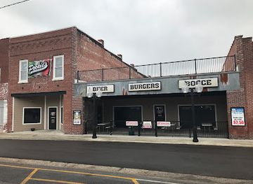
Pookie's Beer, Burgers & Bocce
Experience the perfect blend of delicious burgers, refreshing beers, and bocce fun at Pookie's Beer, Burgers & Bocce in Marion.
-
Grill
618 Tap House
Discover the delightful fusion of flavor and fun at 618 Tap House, Marion's favorite grill and bar destination for great food and drinks.
-
Grill
Shotgun Eddys
Discover the best grill experience at Shotgun Eddys in Eddyville, Illinois - a delightful spot for mouthwatering dishes and a warm atmosphere.
-
Grill
PK’s Bar
Experience the lively atmosphere and delicious grill options at PK’s Bar in Carbondale, Illinois, where great food meets affordable prices.


Best shops in Shawnee National Forest
Shopping opportunities are concentrated in the communities around Shawnee rather than at isolated trailheads. Carbondale, Marion, Harrisburg, Vienna, Anna-Jonesboro and Golconda provide provisions, outdoor equipment and everyday supplies, while smaller towns and rural stores can be useful for food and basic necessities. Visitors may find locally produced food, seasonal farm goods, handmade items, artwork and regional souvenirs, although the selection varies by settlement and business. Southern Illinois craft traditions can include pottery, woodwork, textiles and visual art, but individual makers and sales locations should be checked locally rather than assumed to operate year-round. Buying provisions before entering the forest is sensible, particularly for trips to eastern recreation areas or quiet canyon country where permanent retail facilities are sparse.
-
Hiking area
Garden of the Gods
Explore the breathtaking Garden of the Gods, a premier hiking destination in Illinois, renowned for its stunning rock formations and scenic beauty.
-
Gift shop
Garden of the Gods Outpost
Discover the enchanting Garden of the Gods Outpost, where stunning views, unique gifts, and delicious food create an unforgettable experience in Southern Illinois.
-
Park
Bell Smith Springs Scenic Area
Experience the breathtaking landscapes and serene waters of Bell Smith Springs Scenic Area, a true natural oasis in Illinois perfect for outdoor adventures.
-
Hiking area
Jackson Falls
Explore the breathtaking hiking trails and picturesque waterfalls of Jackson Falls in Simpson, Illinois, a haven for outdoor enthusiasts.


Get your free copy of our complete guide to Shawnee National Forest, delivered straight to you.
Everything on this page, from attractions and restaurants to essentials and local phrases, in one PDF you can read offline, print or share.
Already have an account? Sign in
Your Shawnee National Forest guide is ready.
We'll send it to · Not you? Sign out

Getting your guide ready…
We are putting together a fresh copy of the Shawnee National Forest guide. This can take up to a minute.
This can take a few moments. If your browser asks, choose Allow so the download can start. You'll find the guide in your Downloads folder.
Nothing happened? Download it again
Sorry, the guide is taking longer than usual. Please try again in a minute, or get it by email instead.
Shawnee National Forest essentials
Currency and Payment
Safety
Emergency Situations
Do's and Don'ts
Local Tips
From Eve
Local phrases worth knowing
You don't need to get them perfect. A few words go a long way, and locals appreciate the effort.
Basics
| English | Local | Say it |
|---|---|---|
| Hello | Niitakat | [nee-ta-kat] |
| Goodbye | Wapimini | [wa-pee-mi-nee] |
| Yes | Eeyo | [ee-yo] |
| No | Aahpeetokwa | [aah-pee-to-kwa] |
| Please/You're welcome | Kwakwaho | [kwa-kwa-ho] |
| Thank you | Ninaskum | [nee-nas-kum] |
| Excuse me/Sorry | Wapamini | [wa-pa-mi-nee] |
| How are you? | Nahiyapo | [na-hi-ya-po] |
| Fine. And you? | Heka. Niitako? | [he-ka. nee-ta-ko?] |
| Do you speak English? | Aahpeetokwa kiilaweeman | [aah-pee-to-kwa kee-la-wee-man] |
| I don't understand | Aahpiilokwa | [aah-pee-lo-kwa] |
Eating & Drinking
| English | Local | Say it |
|---|---|---|
| I'd like to see the menu, please | Kiilaweeman eemilokwa | [kee-la-wee-man ee-mi-lo-kwa] |
| I don't eat meat | Aahpeetokwa wiiyekwaneeta | [aah-pee-to-kwa wee-ye-kwa-nee-ta] |
| Cheers! | Awanowat | [a-wa-no-wat] |
| I would like to pay, please | Kiilaweeman kwiilokwa | [kee-la-wee-man kwee-lo-kwa] |
Emergencies
| English | Local | Say it |
|---|---|---|
| Help! | Kohpomah | [koh-po-ma] |
| Go away! | Tepahki | [te-pah-ki] |
| Call the Police! | Kohpomah weloohkoohweeman | [koh-po-ma we-looh-koo-wee-man] |
| Call a doctor! | Kohpomah weloohneehkohta | [koh-po-ma we-looh-nee-ko-ta] |
| I'm lost | Aahpeetokwa welohkwa | [aah-pee-to-kwa we-lo-kwa] |
| I'm ill | Aahpeetokwa wiiwiiyepi | [aah-pee-to-kwa wee-wee-ye-pi] |
Shopping
| English | Local | Say it |
|---|---|---|
| I'd like to buy... | Kiilaweeman kiiyekwaneeta | [kee-la-wee-man kee-ye-kwa-nee-ta] |
| I'm just looking | Niisheewat | [nee-shee-wat] |
| How much is it? | Kwiiyekwaneeta kiilaweeman | [kwee-ye-kwa-nee-ta kee-la-wee-man] |
| That's too expensive | Kwaiikweemihki | [kwa-ee-kwee-mi-hki] |
| Can you lower the price? | Aahpeetokwa kiiweeman | [aah-pee-to-kwa kee-wee-man] |
Time & Numbers
| English | Local | Say it |
|---|---|---|
| What time is it? | Kwiilohkwa oohkiimihki? | [kwee-lo-kwa ooh-kee-mi-hki] |
| It's one o'clock | Oohkiimihki eeyo | [ooh-kee-mi-hki ee-yo] |
| Half past (10) | Wiiyekwaneeta niilomah | [wee-ye-kwa-nee-ta nee-lo-ma] |
| Morning | Oohkiimihki | [ooh-kee-mi-hki] |
| Afternoon | Oohkiimihki | [ooh-kee-mi-hki] |
| Evening | Oohkiimihki | [ooh-kee-mi-hki] |
| Yesterday | Kiiyekwaneeta niilohtasihki | [kee-ye-kwa-nee-ta nee-lo-ta-si-hki] |
| Today | Kiiyekwaneeta niilohpokwa | [kee-ye-kwa-nee-ta nee-lo-po-kwa] |
| Tomorrow | Kiiyekwaneeta niilohki | [kee-ye-kwa-nee-ta nee-lo-ki] |
| 1 | Niilomah | [nee-lo-ma] |
| 2 | Niilomahpi | [nee-lo-ma-pee] |
| 3 | Niilomahpiyokwa | [nee-lo-ma-pee-yo-kwa] |
| 4 | Niilomahpeetokwa | [nee-lo-ma-pee-to-kwa] |
| 5 | Niilomahweeman | [nee-lo-ma-wee-man] |
| 6 | Niilomahkweemihki | [nee-lo-ma-kwee-mi-hki] |
| 7 | Niilomahkweemihkiyokwa | [nee-lo-ma-kwee-mi-hki-yo-kwa] |
| 8 | Niilomahkweemihkiyoweman | [nee-lo-ma-kwee-mi-hki-yo-wee-man] |
| 9 | Niilomahkweemihkiyowemanyokwa | [nee-lo-ma-kwee-mi-hki-yo-wee-man-yo-kwa] |
| 10 | Niilomahkweemihkiyowemanpi | [nee-lo-ma-kwee-mi-hki-yo-wee-man-pee] |
Transport & Directions
| English | Local | Say it |
|---|---|---|
| Where's a/the...? | Kwiiyekwaneeta... | [kwee-ye-kwa-nee-ta] |
| What's the address? | Kwiiyekwaneeta niitako... | [kwee-ye-kwa-nee-ta nee-ta-ko] |
| Can you show me (on the map)? | Aahpeetokwa niitako... | [aah-pee-to-kwa nee-ta-ko] |
| When's the next (bus)? | Kwiilohkwa niitako... | [kwee-lo-kwa nee-ta-ko] |
| A ticket (to ....) | Niisheewat... | [nee-shee-wat] |
History of Shawnee National Forest
Ancient Landscapes and Indigenous Homelands
The sandstone scenery of the Shawnee Hills reflects ancient geological processes rather than a human historical event. Over long periods, resistant sandstone layers were exposed and shaped into bluffs, shelters and narrow canyons by weathering and erosion. Human communities have used the Ohio and Mississippi valleys and the forested uplands for thousands of years. The wider southern Illinois region contains important Indigenous archaeological landscapes, including the Mississippian centre at Cahokia to the north, although Cahokia is not part of Shawnee National Forest. Historic Indigenous nations connected with the region include the Shawnee, whose name survives in the forest, as well as other peoples affected by migration, displacement and changing colonial boundaries.
Settlement, Farms and River Commerce
European-American settlement expanded through southern Illinois during the eighteenth and nineteenth centuries, following river corridors and fertile valleys while upland areas remained more heavily wooded. Communities around the forest developed through farming, timber work, ferrying, mining and trade along the Ohio and Mississippi rivers. The river town of Golconda preserves part of this regional story, while Cave-in-Rock on the Ohio has long been associated with river travel and settlement beyond the forest's administrative boundaries. Small farms, country roads and scattered communities still shape the cultural landscape around the national forest.
From Exploited Woodland to Public Forest
By the early twentieth century, extensive timber cutting, farming and erosion had altered many parts of the southern Illinois uplands. During the New Deal era, the federal government began acquiring and restoring worn agricultural and forest lands, and Shawnee National Forest was formally established in 1933. Civilian Conservation Corps workers contributed to conservation and recreation projects during the 1930s, part of a wider national effort to stabilise rural landscapes and create public amenities. The resulting forest was not an untouched wilderness but a managed public landscape shaped by reforestation, fire control, roads, recreation and habitat protection.
Recreation and Conservation Today
In the later twentieth century, Shawnee National Forest became increasingly known for scenic recreation, particularly at Garden of the Gods, Rim Rock, Bell Smith Springs and the forest's climbing and equestrian areas. Management has had to balance public access with the protection of sandstone formations, waterways, mature woodland, wetlands and wildlife habitat. The forest supports dispersed recreation across a large working landscape, while neighbouring state natural areas and state parks add further conservation sites outside its boundaries. Contemporary visitors therefore encounter both a recreational destination and an evolving programme of stewardship in which roads, trails, forests and rural communities remain closely connected.
Shawnee National Forest in Photos
Browse through our photo collection highlighting the charm and character of the destination.
Neighbouring destination travel guides
The closest destinations to Shawnee National Forest, if you have time for more than one.
-

-

-

-

-


Swipe for more destinations
Explore more

Explore more of Shawnee Hills
Explore Shawnee Hills forests, sandstone bluffs, vineyards, river towns and outdoor trails across southern Illinois.
Explore Shawnee Hills
Explore more of Illinois
Discover Illinois: From Chicago's iconic skyline to the tranquil beauty of its countryside, experience the diverse allure of the Prairie State.
Explore Illinois