

Ixtapa (Ixtapa-Zihuatanejo) Travel Guide - Free
Explore Ixtapa in Ixtapa-Zihuatanejo with Evendo's free guide. Find the best shops, historic streets, restaurants, and gems on web or mobile.


Ixtapa, Mexico offers a planned Pacific resort, Playa El Palmar, marina walks, cycling trails, golf and boat trips near Zihuatanejo for relaxed beach holidays.
Planned Resort, Open Pacific Coast
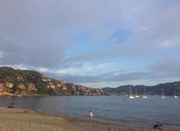
Ixtapa occupies a broad stretch of Mexico’s Pacific coast north-west of Zihuatanejo, with a landscape shaped as much by modern planning as by palms, sand and ocean. Developed as a purpose-built resort from the 1970s, it is more spacious and ordered than historic Zihuatanejo: hotels, apartment complexes, landscaped avenues and the marina are arranged around Playa El Palmar, the principal beach. The result is a destination designed for an easy resort rhythm, with long coastal views, generous public spaces and relatively straightforward connections between the beach, accommodation areas and golfing facilities.Read more about Ixtapa
Beach, Marina and Outdoor Life
A Gateway to Zihuatanejo
Explore Ixtapa on the map
A handpicked selection of must-see spots in Ixtapa, mapped for you.
Best hotels in Ixtapa
Ixtapa essentials
Getting There
Getting Around
Safety
Emergency Situations
Do's and Don'ts
Local Tips

From Eve
Local phrases worth knowing
You don't need to get them perfect. A few words go a long way, and locals appreciate the effort.
Basics
| English | Local | Say it |
|---|---|---|
| Hello | Hola | [oh-lah] |
| Goodbye | Adiós | [ah-dee-ohs] |
| Yes | Sí | [see] |
| No | No | [noh] |
| Please/You're welcome | Por favor/De nada | [por fah-vor/deh nah-dah] |
| Thank you | Gracias | [grah-see-ahs] |
| Excuse me/Sorry | Perdón/Lo siento | [pair-dohn/loh see-en-toh] |
| How are you? | ¿Cómo estás? | [koh-moh ehs-tahs] |
| Fine. And you? | Bien. ¿Y tú? | [bee-ehn. ee too] |
| Do you speak English? | ¿Hablas inglés? | [ah-blahs een-glehs] |
| I don't understand | No entiendo | [noh ehn-tee-ehn-doh] |
Eating & Drinking
| English | Local | Say it |
|---|---|---|
| I'd like to see the menu, please | Me gustaría ver el menú, por favor | [meh goo-stah-ree-ah behr ehl meh-noo, pour fah-vor] |
| I don't eat meat | No como carne | [noh koh-moh kahr-neh] |
| Cheers! | ¡Salud! | [sah-lood] |
| I would like to pay, please | Me gustaría pagar, por favor | [meh goo-stah-ree-ah pah-gahr, pour fah-vor] |
Emergencies
| English | Local | Say it |
|---|---|---|
| Help! | ¡Ayuda! | [ah-yoo-dah] |
| Go away! | ¡Vete! | [veh-teh] |
| Call the Police! | ¡Llama a la Policía! | [yah-mah ah lah poh-lee-see-ah] |
| Call a doctor! | ¡Llama a un médico! | [yah-mah ah oon meh-dee-koh] |
| I'm lost | Estoy perdido/a | [ehs-toy pair-dee-doh/ah] |
| I'm ill | Estoy enfermo/a | [ehs-toy ehn-fehr-moh/ah] |
Shopping
| English | Local | Say it |
|---|---|---|
| I'd like to buy... | Me gustaría comprar... | [meh goo-stah-ree-ah kohm-prar] |
| I'm just looking | Sólo estoy mirando | [soh-loh ehs-toy mee-rahn-doh] |
| How much is it? | ¿Cuánto cuesta? | [kwan-toh kweh-stah] |
| That's too expensive | Eso es demasiado caro | [eh-soh ehs deh-mah-see-ah-doh kah-roh] |
| Can you lower the price? | ¿Puedes bajar el precio? | [pweh-dehs bah-har ehl pree-syoh] |
Time & Numbers
| English | Local | Say it |
|---|---|---|
| What time is it? | ¿Qué hora es? | [keh oh-rah ehs] |
| It's one o'clock | Es la una | [ehs lah oo-nah] |
| Half past (10) | Son las diez y media | [sohn lahs dyehs ee meh-dee-ah] |
| Morning | Mañana | [mah-nyah-nah] |
| Afternoon | Tarde | [tahr-deh] |
| Evening | Noche | [noh-cheh] |
| Yesterday | Ayer | [ah-yehr] |
| Today | Hoy | [oy] |
| Tomorrow | Mañana | [mah-nyah-nah] |
| 1 | Uno | [oo-noh] |
| 2 | Dos | [dohs] |
| 3 | Tres | [trehs] |
| 4 | Cuatro | [kwah-troh] |
| 5 | Cinco | [seen-koh] |
| 6 | Seis | [says] |
| 7 | Siete | [syeh-teh] |
| 8 | Ocho | [oh-choh] |
| 9 | Nueve | [nweh-veh] |
| 10 | Diez | [dyehs] |
Transport & Directions
| English | Local | Say it |
|---|---|---|
| Where's a/the...? | ¿Dónde está...? | [dohn-deh ehs-tah] |
| What's the address? | ¿Cuál es la dirección? | [kwahl ehs lah dee-rehk-syohn] |
| Can you show me (on the map)? | ¿Puedes mostrarme (en el mapa)? | [pweh-dehs mohs-trar-meh (ehn ehl mah-pah)] |
| When's the next (bus)? | ¿Cuándo es el próximo (autobús)? | [kwan-doh ehs ehl proh-ksee-moh (ow-toh-boos)] |
| A ticket (to ....) | Un boleto (a ....) | [oon boh-leh-toh (ah)] |
History of Ixtapa
From Coastal Land to Resort Planning
Before tourism transformed the area, the coastal plain around present-day Ixtapa was associated with agricultural land, coconut cultivation and small-scale local activity rather than a large urban settlement. Its broad shoreline and proximity to Zihuatanejo made it suitable for planned tourism, but the resort was not an organic extension of the older town. In the 1970s, Mexico’s national tourism development agency, FONATUR, selected Ixtapa for one of its integrated resort projects, bringing coordinated investment in roads, utilities, hotels and recreational facilities. This planning created the spatial character visitors see today: wide avenues, landscaped grounds and separated hotel, residential, commercial and leisure zones.
The Resort Takes Shape
During the late twentieth century, Ixtapa developed as a complementary resort to Zihuatanejo, using the older town’s cultural and maritime identity while offering a purpose-built setting for larger hotels and organised recreation. Playa El Palmar became the neighbourhood’s principal public beach, while golf, tennis and marina facilities broadened its appeal beyond seaside bathing. New accommodation and commercial areas were arranged along the coast and inland corridors, giving Ixtapa a low-density, spacious appearance compared with more tightly built Mexican resort centres. The division between resort infrastructure and older local communities also became part of the area’s social geography, with visitors frequently moving between Ixtapa’s planned environment and Zihuatanejo’s established urban centre.
A Mature Coastal Destination
As Ixtapa matured, its identity expanded from a hotel development into a wider leisure district supported by a marina, golf facilities, cycling routes and excursions to nearby beaches and islands. Landscaped public areas and the Ciclopista helped preserve access to the coastal setting while accommodating continued tourism growth. The resort remains closely linked commercially and geographically with Zihuatanejo, yet its built form continues to reflect its planned origins. Contemporary debates around coastal development, environmental protection and public access are relevant to the area’s future, particularly where tourism infrastructure meets beaches, wetlands and remaining vegetation. Ixtapa’s history is therefore visible less in old buildings than in the deliberate layout of the resort itself.
Ixtapa in Photos
Browse through our photo collection highlighting the charm and character of the destination.
Neighbourhoods near Ixtapa
The closest neighbourhoods to Ixtapa, if you have time for more than one stop.

Swipe for more neighbourhoods
Explore more
Explore more of Ixtapa-Zihuatanejo
Ixtapa-Zihuatanejo pairs Pacific beaches, a historic fishing town, resort comforts, seafood, culture and outdoor adventures on Mexico’s Costa Grande.
Explore Ixtapa-Zihuatanejo