

Free Ixtapa-Zihuatanejo Travel Guide & Mobile App
Plan your Ixtapa-Zihuatanejo trip with Evendo. Get free guides to top attractions, restaurants, hotels, and bars. Web access or download the mobile app.


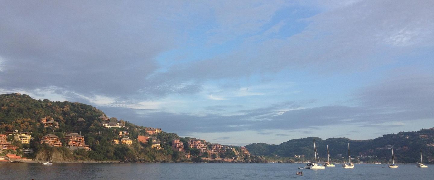


Ixtapa-Zihuatanejo pairs Pacific beaches, a historic fishing town, resort comforts, seafood, culture and outdoor adventures on Mexico’s Costa Grande.
Two Coastal Identities
Ixtapa-Zihuatanejo brings together two adjoining destinations on Mexico’s Costa Grande in Guerrero. Ixtapa is a carefully planned resort built around a long sweep of golden sand, a marina, golf courses and a broad coastal cycle path. Zihuatanejo, by contrast, retains the scale and rhythm of a traditional Pacific fishing town, with boats drawn up near Playa Principal, seafood restaurants along the waterfront and streets rising gently into residential hills. Together they offer an appealing balance: polished resort facilities in Ixtapa and a more intimate, working coastal atmosphere in Zihuatanejo.Read more about Ixtapa-Zihuatanejo
Beaches, Bays and Outdoor Life
Culture and Coastal Character
When is the best time to visit Ixtapa-Zihuatanejo?
Best: January–March · 30–31°C| Month | High (°C) | Rainfall (mm) |
|---|---|---|
| January (best) | 30 | 10 |
| February (best) | 30 | 7 |
| March (best) | 31 | 4 |
| April | 32 | 2 |
| May | 33 | 1 |
| June | 33 | 0 |
| July | 33 | 1 |
| August | 33 | 1 |
| September | 33 | 2 |
| October | 32 | 8 |
| November | 31 | 14 |
| December | 30 | 15 |
Getting to and around Ixtapa-Zihuatanejo
How to get there
Transportation
Explore Ixtapa-Zihuatanejo on the map
Plan your Ixtapa-Zihuatanejo trip on one map. See where the top attractions, landmarks, restaurants, bars and hotels are, find what's near where you're staying, and book hotels and experiences in a few clicks.
Neighbourhoods in Ixtapa-Zihuatanejo
-

-


Swipe for more neighbourhoods
Best hotels in Ixtapa-Zihuatanejo
Get your free copy of our complete guide to Ixtapa-Zihuatanejo, delivered straight to you.
Everything on this page, from attractions and restaurants to essentials and local phrases, in one PDF you can read offline, print or share.
Already have an account? Sign in
Your Ixtapa-Zihuatanejo guide is ready.
We'll send it to · Not you? Sign out

Getting your guide ready…
We are putting together a fresh copy of the Ixtapa-Zihuatanejo guide. This can take up to a minute.
This can take a few moments. If your browser asks, choose Allow so the download can start. You'll find the guide in your Downloads folder.
Nothing happened? Download it again
Sorry, the guide is taking longer than usual. Please try again in a minute, or get it by email instead.
Ixtapa-Zihuatanejo essentials
Currency and Payment
Safety
Emergency Situations
Do's and Don'ts
Local Tips
From Eve
Local phrases worth knowing
You don't need to get them perfect. A few words go a long way, and locals appreciate the effort.
Basics
| English | Local | Say it |
|---|---|---|
| Hello | Hola | [oh-lah] |
| Goodbye | Adiós | [ah-dee-ohs] |
| Yes | Sí | [see] |
| No | No | [noh] |
| Please/You're welcome | Por favor/De nada | [por fah-bor/de nah-dah] |
| Thank you | Gracias | [grah-see-ahs] |
| Excuse me/Sorry | Perdón/Lo siento | [pair-dohn/loh see-ehn-toh] |
| How are you? | ¿Cómo estás? | [koh-moh ehs-tahs] |
| Fine. And you? | Bien. ¿Y tú? | [bee-ehn. ee too] |
| Do you speak English? | ¿Hablas inglés? | [ah-blahs een-glehs] |
| I don't understand | No entiendo | [noh ehn-tee-ehn-doh] |
Eating & Drinking
| English | Local | Say it |
|---|---|---|
| I'd like to see the menu, please | Me gustaría ver el menú, por favor | [meh goo-stah-ree-ah behr ehl meh-noo, por fah-bor] |
| I don't eat meat | No como carne | [noh koh-moh kahr-neh] |
| Cheers! | ¡Salud! | [sah-lood] |
| I would like to pay, please | Me gustaría pagar, por favor | [meh goo-stah-ree-ah pah-gar, por fah-bor] |
Emergencies
| English | Local | Say it |
|---|---|---|
| Help! | ¡Ayuda! | [ah-yoo-dah] |
| Go away! | ¡Vete! | [veh-teh] |
| Call the Police! | ¡Llama a la Policía! | [yah-mah ah lah poh-lee-see-ah] |
| Call a doctor! | ¡Llama a un médico! | [yah-mah ah oon meh-dee-koh] |
| I'm lost | Estoy perdido | [ehs-toy pair-dee-doh] |
| I'm ill | Estoy enfermo | [ehs-toy ehn-fehr-moh] |
Shopping
| English | Local | Say it |
|---|---|---|
| I'd like to buy... | Me gustaría comprar... | [meh goo-stah-ree-ah kohm-prahr] |
| I'm just looking | Sólo estoy mirando | [soh-loh ehs-toy mee-rahn-doh] |
| How much is it? | ¿Cuánto cuesta? | [kwan-to kwehs-tah] |
| That's too expensive | Eso es demasiado caro | [eh-soh ehs deh-mah-syah-doh kah-roh] |
| Can you lower the price? | ¿Puedes bajar el precio? | [pweh-dehs bah-har ehl pree-syoh] |
Time & Numbers
| English | Local | Say it |
|---|---|---|
| What time is it? | ¿Qué hora es? | [keh oh-rah ehs] |
| It's one o'clock | Es la una | [ehs lah oo-nah] |
| Half past (10) | Y media (10) | [ee meh-dee-ah (deez)] |
| Morning | Mañana | [mah-nyah-nah] |
| Afternoon | Tarde | [tahr-deh] |
| Evening | Noche | [noh-cheh] |
| Yesterday | Ayer | [ah-yehr] |
| Today | Hoy | [oy] |
| Tomorrow | Mañana | [mah-nyah-nah] |
| 1 | Uno | [oo-noh] |
| 2 | Dos | [dohs] |
| 3 | Tres | [trehs] |
| 4 | Cuatro | [kwah-troh] |
| 5 | Cinco | [seen-koh] |
| 6 | Seis | [says] |
| 7 | Siete | [syeh-teh] |
| 8 | Ocho | [oh-choh] |
| 9 | Nueve | [nweh-veh] |
| 10 | Diez | [dyehs] |
Transport & Directions
| English | Local | Say it |
|---|---|---|
| Where's a/the...? | ¿Dónde está un/el...? | [dohn-deh ehs-tah oon/ehl] |
| What's the address? | ¿Cuál es la dirección? | [kwahl ehs lah dee-rehk-syohn] |
| Can you show me (on the map)? | ¿Puedes mostrarme (en el mapa)? | [pweh-dehs mohs-trahr-meh (ehn ehl mah-pah)] |
| When's the next (bus)? | ¿Cuándo pasa el próximo (autobús)? | [kwan-doh pah-sah ehl proh-ksee-moh (ow-toh-boos)] |
| A ticket (to ....) | Un boleto (a ...) | [oon boh-leh-toh (ah ...)] |
History of Ixtapa-Zihuatanejo
Pre-Hispanic Costa Grande Communities
The bays and river valleys around present-day Zihuatanejo supported Indigenous communities long before the arrival of Spain. Archaeological evidence from the Costa Grande records settlements involved in fishing, farming, craft production and exchange along Mexico’s Pacific coast. The region was associated with several cultural traditions rather than a single uninterrupted political state, and later Indigenous groups included Cuitlatec communities. Objects recovered from coastal sites, including ceramics and figurines, are interpreted in the Museo Arqueológico de la Costa Grande. These remains establish a long relationship between people and the sea, while also showing that the area formed part of wider cultural and commercial networks across Guerrero.
Spanish Voyages and the Pacific Port
After the Spanish conquest of central Mexico, the Pacific coast became strategically important for maritime exploration and trade. Zihuatanejo’s sheltered bay was used by vessels travelling along the coast, and in the sixteenth century the area became associated with expeditions seeking routes across the Pacific. The most celebrated episode was the departure of Andrés de Urdaneta from the nearby Pacific coast in 1565 during the Spanish expedition that helped establish the Manila galleon route. Zihuatanejo itself remained a small coastal settlement rather than a major colonial city, with local life based largely on fishing, agriculture and limited commercial activity.
A Fishing Town on Guerrero’s Coast
For much of the colonial and post-colonial period, Zihuatanejo developed at a modest pace. Its bay provided a natural harbour for local fishing craft, while inland communities cultivated tropical crops and maintained connections with other settlements in Guerrero. The town’s low-rise form and waterfront economy endured into the twentieth century, when fishing, small-scale commerce and seasonal visitors shaped its identity. The surrounding Costa Grande also experienced the wider changes affecting rural Mexico, including improved roads, migration and the gradual expansion of tourism. Zihuatanejo’s present-day waterfront, with working boats alongside restaurants and promenades, still reflects this layered coastal history.
Ixtapa’s Planned Resort Development
Ixtapa emerged from a major tourism-planning initiative in the 1970s, when Mexico’s national tourism authorities selected the area for a purpose-built resort. Unlike organically developed Zihuatanejo, it was laid out with hotels, apartment complexes, a marina, golf facilities, landscaped roads and protected open spaces. The planning aimed to concentrate resort development while retaining beaches and environmental areas along the coast. Ixtapa’s growth transformed the local economy and brought international tourism infrastructure to the region, but it also created a distinctly different urban landscape from the older fishing town across the bay.
A Shared Contemporary Destination
Ixtapa and Zihuatanejo are now commonly presented as a single visitor destination, although they retain separate characters and administrative histories within Guerrero. Tourism, fishing, hospitality, crafts and services form the foundation of the local economy, while nearby villages and natural areas broaden the region’s cultural and ecological setting. Zihuatanejo continues to centre on its bay, waterfront and traditional commercial streets; Ixtapa remains defined by planned resort infrastructure and broad beaches. This contrast is central to the destination’s identity, allowing visitors to encounter both a modern Pacific resort and a long-established coastal community within a short distance.
Ixtapa-Zihuatanejo in Photos
Browse through our photo collection highlighting the charm and character of the destination.
Cities near Ixtapa-Zihuatanejo
The closest cities to Ixtapa-Zihuatanejo, if you have time for more than one stop.
-
-

-

-

-


Swipe for more cities
Explore more

Explore more of Mexico
Discover Mexico: A land of ancient ruins, vibrant culture, and stunning natural landscapes. Experience diverse cuisine, rich traditions, and warm hospitality.
Explore Mexico