

North Cascades National Park Travel Guide - Free Web & App
Your ultimate guide to North Cascades National Park. Discover top landmarks, proposed trips, and local tips. Free on the web or via the Evendo companion app.


North Cascades National Park in Washington offers glaciers, alpine lakes, jagged peaks, wilderness trails and scenic drives through the American mountains.
A Rugged Mountain Landscape
North Cascades National Park occupies a remote, mountainous section of northern Washington, close to the Canadian border and east of Bellingham. Its steep valleys, jagged summits, extensive glaciers, alpine meadows and densely forested lower slopes form one of the least developed large landscapes in the contiguous United States. The park is part of the wider North Cascades National Park Service Complex, which also includes Ross Lake National Recreation Area and Lake Chelan National Recreation Area; these adjoining areas provide much of the region’s road access, boating infrastructure and visitor accommodation.Read more about North Cascades National Park
Exploring the Park
When is the best time to visit North Cascades National Park?
Best: June–August · 20–24°C| Month | High (°C) | Rainfall (mm) |
|---|---|---|
| January | 6 | 160 |
| February | 8 | 120 |
| March | 10 | 110 |
| April | 13 | 90 |
| May | 17 | 70 |
| June (best) | 20 | 60 |
| July (best) | 24 | 40 |
| August (best) | 24 | 50 |
| September | 20 | 70 |
| October | 14 | 110 |
| November | 9 | 160 |
| December | 6 | 170 |
Getting to and around North Cascades National Park
How to get there
Transportation
Best attractions in North Cascades National Park
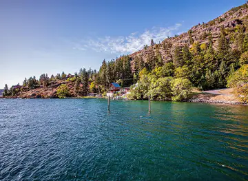
North Cascades National Park and its adjoining National Park Service complex offer attractions spread across a large mountain landscape rather than concentrated in a single visitor centre. Along State Route 20, Diablo Lake’s turquoise reservoir, Ross Lake and the historic hydroelectric settlement of Newhalem provide the most accessible introduction to the region. The park’s deeper country is reached on trails such as the route to Cascade Pass and Sahale Arm, where high basins, glaciers and serrated ridges dominate the view, or towards Hidden Lake and its alpine surroundings. Ross Lake supports boat-based exploration and access to remote trails, while Lake Chelan National Recreation Area leads towards Stehekin, a roadless community at the lake’s northern end. The Pacific Crest Trail crosses the broader national park region, although individual access points and conditions vary. Washington Pass overlooks, east of the park on the North Cascades Highway, are notable nearby scenery in the Okanogan-Wenatchee National Forest rather than attractions inside the national park.
-
Tourist attraction
Diablo Lake Vista Point
Experience breathtaking views and vibrant turquoise waters at Diablo Lake Vista Point, a must-see scenic spot in Washington's North Cascades.
-
Tourist attraction
Washington Pass Observation Site
Discover the stunning vistas of the North Cascades at Washington Pass Observation Site, a scenic gem for nature lovers and hikers in Mazama, Washington.
-
Park
Ross Lake National Recreation Area
Explore the stunning landscapes and outdoor adventures at Ross Lake National Recreation Area in Washington, a paradise for nature lovers and adventure seekers.
-
Tourist attraction
Gorge Overlook Trail
Discover the beauty of nature at Gorge Overlook Trail—an enchanting hiking area in Rockport, Washington, offering stunning views and serene landscapes.


Best landmarks in North Cascades National Park
The park’s most important landmarks are overwhelmingly natural: jagged granite and metamorphic peaks, deep glacial valleys, high passes, icefields and the remaining glaciers that give the North Cascades their distinctive profile. Cascade Pass is a historic mountain route and a major landscape landmark, linking dramatic alpine terrain with views towards Sahale Arm and surrounding summits. Ross Lake and Diablo Lake are prominent human-shaped features as well as scenic waters, their reservoirs formed by the Skagit River hydroelectric dams. Newhalem’s power-development heritage provides the main concentration of built history within the road-accessible complex, while the remote community of Stehekin represents the distinctive settlement pattern of the upper Lake Chelan valley. The broader North Cascades Highway adds notable viewpoints such as Washington Pass, but these lie outside the national park in the Okanogan-Wenatchee National Forest. Together, mountains, lakes, glaciers, dams and historic routes express the area’s overlapping natural and human histories.
-
Tourist attraction
Diablo Lake Vista Point
Experience the stunning turquoise waters and breathtaking mountain views at Diablo Lake Vista Point, a must-visit scenic spot in Washington.

Explore North Cascades National Park on the map
Plan your trip on one map. See where the top attractions, landmarks, restaurants and hotels are, and book hotels and experiences in a few clicks.
Best hotels in North Cascades National Park
Best restaurants in North Cascades National Park
Dining within North Cascades National Park is extremely limited, with no developed restaurant district and few opportunities to buy food once visitors leave the main roads and settled gateways. Marblemount, Concrete, Rockport and Newhalem provide the most relevant western-side stops, while Winthrop and Methow Valley communities serve travellers approaching from the east when State Route 20 is open; Chelan is the principal larger base for the Lake Chelan approach. Cafés, diners, pubs, groceries and casual restaurants in these communities reflect the practical needs of mountain travellers and often feature familiar Pacific Northwest ingredients, baked goods and locally produced foods, but availability varies by season. Stehekin has limited food services associated with its small settlement and visitor facilities, so boat passengers and backcountry travellers should plan provisions carefully. Picnic meals and packed food remain essential for many hikes.
-
American
Mondo Restaurant
Discover Mondo Restaurant in Marblemount for an unforgettable American dining experience amidst breathtaking scenery.
-
Restaurant
Upriver Grill & Taproom
Experience delicious American cuisine at Upriver Grill & Taproom in Marblemount, WA – where local flavors meet stunning natural beauty.


Best bars in North Cascades National Park
North Cascades National Park has no nightclub scene and very little organised nightlife, as most visitors spend the evening in campsites, cabins or accommodation in nearby communities. Traditional pubs, taverns and casual bars in places such as Marblemount, Concrete, Winthrop and Chelan provide the principal opportunities for a drink or informal socialising, with the atmosphere ranging from working mountain settlement to western-themed tourist town. Newhalem and other park-service communities are quiet and oriented towards the road, reservoirs and surrounding trails rather than late-night entertainment. In Stehekin, evenings are generally shaped by the small settlement’s limited facilities and the rhythms of boat and lodge access. Seasonal community events, local music and hospitality venues may occur in gateway towns, but visitors should not assume that performances or late opening are available outside the main summer period.
-
Tourist attraction
Diablo Lake Vista Point
Experience breathtaking views at Diablo Lake Vista Point, a scenic spot in the heart of Washington's North Cascades National Park.
-
Pizza
Annie's Pizza Station
Discover the authentic Italian flavors at Annie's Pizza Station, a top-rated pizza destination in Concrete, WA.
-
Hamburger
Cascade Burgers
Discover Cascade Burgers in Concrete, WA - where delicious burgers meet breathtaking scenery and warm hospitality.
-
American
Mondo Restaurant
Discover a unique American dining experience at Mondo Restaurant in Marblemount, WA, where local flavors meet a cozy atmosphere.


Best shops in North Cascades National Park
Shopping inside North Cascades National Park is limited to practical visitor needs and interpretive or souvenir items associated with National Park Service facilities, rather than a conventional retail scene. Marblemount, Concrete and other Skagit Valley communities are the most useful western-side places for groceries, fuel, outdoor supplies and locally made goods, while Winthrop offers a broader selection of independent shops and regional souvenirs on the eastern approach. Chelan serves visitors heading towards Lake Chelan and Stehekin, with food provisions, outdoor equipment and products connected to the lake and surrounding agricultural country. Farm shops, small galleries, craft businesses and local food producers may be found in gateway communities, though opening patterns can be seasonal. Visitors should purchase specialist equipment and substantial provisions before entering remote areas, where choice is narrow and resupply is not guaranteed.
-
Tourist attraction
Diablo Lake Vista Point
Experience breathtaking views at Diablo Lake Vista Point, a scenic gem in North Cascades National Park with stunning turquoise waters and majestic mountains.
-
National park
North Cascades National Park
Explore North Cascades National Park's breathtaking landscapes, diverse wildlife, and serene wilderness in Washington's Pacific Northwest.
-
Visitor center
North Cascades Visitor Center
Discover the gateway to adventure at the North Cascades Visitor Center, where nature and knowledge collide in breathtaking beauty.
-
Bakery
5b's Bakery & Eatery
Experience the charm of 5b's Bakery & Eatery in Concrete, WA, with its mouthwatering pastries, breakfast delights, and gluten-free options in a cozy setting.


Get your free copy of our complete guide to North Cascades National Park, delivered straight to you.
Everything on this page, from attractions and restaurants to essentials and local phrases, in one PDF you can read offline, print or share.
Already have an account? Sign in
Your North Cascades National Park guide is ready.
We'll send it to · Not you? Sign out

Getting your guide ready…
We are putting together a fresh copy of the North Cascades National Park guide. This can take up to a minute.
This can take a few moments. If your browser asks, choose Allow so the download can start. You'll find the guide in your Downloads folder.
Nothing happened? Download it again
Sorry, the guide is taking longer than usual. Please try again in a minute, or get it by email instead.
North Cascades National Park essentials
Currency and Payment
Safety
Emergency Situations
Do's and Don'ts
Local Tips
From Eve
Local phrases worth knowing
You don't need to get them perfect. A few words go a long way, and locals appreciate the effort.
Basics
| English | Local | Say it |
|---|---|---|
| Hello | Həy | [hey] |
| Goodbye | Goodbye | [guhd-bye] |
| Yes | Yes | [yes] |
| No | No | [no] |
| Please/You're welcome | Pleez | [pleez] |
| Thank you | Thank you | [thank yoo] |
| Excuse me/Sorry | Səri | [suh-ree] |
| How are you? | How are you? | [haw ar yoo] |
| Fine. And you? | Fine. And you? | [fahyn. And yoo?] |
| Do you speak English? | Do you speak English? | [doo yoo speek ing-glish?] |
| I don't understand | I don't understand | [eye dohnt un-der-stand] |
Eating & Drinking
| English | Local | Say it |
|---|---|---|
| I'd like to see the menu, please | I'd like to see the menu, please | [ahyd lyk tu see thee men-yoo, pleez] |
| I don't eat meat | I don't eat meat | [eye dohnt eet meet] |
| Cheers! | Cheers! | [cheerz] |
| I would like to pay, please | I would like to pay, please | [eye wood lyk tu pay, pleez] |
Emergencies
| English | Local | Say it |
|---|---|---|
| Help! | Help! | [help] |
| Go away! | Go away! | [goh uh-way] |
| Call the Police! | Call the Police! | [kawl thee puh-lees] |
| Call a doctor! | Call a doctor! | [kawl uh dawk-ter] |
| I'm lost | I'm lost | [ahym lost] |
| I'm ill | I'm ill | [ahym il] |
Shopping
| English | Local | Say it |
|---|---|---|
| I'd like to buy... | I'd like to buy... | [ahyd lyk tu by] |
| I'm just looking | I'm just looking | [ahym jəst look-ing] |
| How much is it? | How much is it? | [haw much iz it] |
| That's too expensive | That's too expensive | [thats too ex-pen-siv] |
| Can you lower the price? | Can you lower the price? | [kan yoo loh-er thee prahys] |
Time & Numbers
| English | Local | Say it |
|---|---|---|
| What time is it? | What time is it? | [wut tyme iz it] |
| It's one o'clock | It's one o'clock | [its wuhn uh-klok] |
| Half past (10) | Half past (10) | [haf past (ten)] |
| Morning | Morning | [mawr-ning] |
| Afternoon | Afternoon | [af-ter-noon] |
| Evening | Evening | [ee-ven-ing] |
| Yesterday | Yesterday | [yest-er-day] |
| Today | Today | [tuh-day] |
| Tomorrow | Tomorrow | [tuh-mawr-oh] |
| 1 | 1 | [wuhn] |
| 2 | 2 | [too] |
| 3 | 3 | [three] |
| 4 | 4 | [for] |
| 5 | 5 | [five] |
| 6 | 6 | [six] |
| 7 | 7 | [seven] |
| 8 | 8 | [eyt] |
| 9 | 9 | [nine] |
| 10 | 10 | [ten] |
Transport & Directions
| English | Local | Say it |
|---|---|---|
| Where's a/the...? | Where's a/the...? | [wheers uh/thee] |
| What's the address? | What's the address? | [wuts thee uh-dres] |
| Can you show me (on the map)? | Can you show me (on the map)? | [kan yoo show mee (on thee map)] |
| When's the next (bus)? | When's the next (bus)? | [wenz thee nekst (bus)] |
| A ticket (to ....) | A ticket (to ....) | [uh tik-it (to)] |
History of North Cascades National Park
Glaciers and Mountain Formation
The North Cascades are part of the Cascade Range, a geologically active mountain system shaped by tectonic uplift, volcanic processes, erosion and repeated glaciation. In the national park, ice has carved deep valleys, sharpened ridges and left basins occupied by lakes and permanent or semi-permanent snowfields. Glaciers continue to alter the landscape, although their extent changes with climate conditions. The resulting combination of rugged relief, high precipitation on western slopes and relatively dry eastern valleys created the distinctive ecological contrasts that define the region.
Indigenous Homelands and Travel Routes
The mountains are within the traditional homelands and use areas of Indigenous peoples, including communities associated with the Skagit, Sauk-Suiattle, Nlaka’pamux and Chelan regions. Rivers, passes and valleys provided routes through terrain that can appear impassable to modern visitors, while fishing, hunting, gathering and other cultural practices connected communities with the landscape. Indigenous knowledge and continuing cultural relationships remain important to understanding the region, although many places now encountered as wilderness have long histories of human travel and use.
Exploration, Mining and Settlement
Non-Indigenous exploration increased during the nineteenth century, followed by prospecting and small-scale mining in parts of the Cascades. Mineral discoveries, timber interests and the search for routes across the mountains influenced settlement and transport, but the steep terrain limited permanent development. Communities along the Skagit River and around Lake Chelan became important gateways, while trails and pack routes connected valleys that were not linked by roads. Remnants of mining activity and historic transport routes contribute to the cultural landscape, even where the surrounding country has returned to forest and wilderness.
Dams, Power and the Skagit Valley
The Skagit River became central to twentieth-century hydroelectric development. Diablo Dam, Ross Dam and Gorge Dam created the reservoirs now associated with Diablo Lake and Ross Lake, supplying electricity to the Seattle region while permanently changing parts of the river valley. Newhalem developed in connection with the Skagit River project and remains a principal visitor settlement on the western side of the complex. The dams and their reservoirs stand alongside protected mountain landscapes, illustrating the continuing tension between industrial infrastructure, regional energy needs and wilderness conservation.
National Park and Wilderness Protection
North Cascades National Park was established in 1968, together with Ross Lake National Recreation Area and Lake Chelan National Recreation Area, creating the North Cascades National Park Service Complex. Later wilderness protection strengthened the emphasis on preserving undeveloped valleys, alpine terrain, glaciers and ecological processes. The park’s history since designation has involved trail management, visitor safety, wildlife protection and monitoring of changing snow and ice conditions. Today, much of the area remains accessible only by foot, boat or aircraft, reflecting a conservation model that limits roads while retaining carefully managed recreational access.
North Cascades National Park in Photos
Browse through our photo collection highlighting the charm and character of the destination.
Neighbouring destination travel guides
The closest destinations to North Cascades National Park, if you have time for more than one.
-

-

-

-
-


Swipe for more destinations
Explore more

Explore more of Northern Cascades
Explore Northern Cascades, Washington, for glacier-clad peaks, alpine lakes, forest trails, scenic drives and the dry valleys east of the crest.
Explore Northern Cascades
Explore more of Washington
Explore Washington State: From the vibrant streets of Seattle to the tranquil beauty of the Olympic Peninsula, discover the diverse landscapes, culture, and adventures awaiting you.
Explore Washington