

Queen Anne (Seattle) Travel Guide - Free
Explore Queen Anne in Seattle with Evendo's free guide. Find the best shops, historic streets, restaurants, and gems on web or mobile.


Queen Anne Seattle pairs grand hilltop homes, sweeping Puget Sound views, Kerry Park, Uptown arts venues and cafés with leafy residential streets.
Hilltop Character
Queen Anne rises north of downtown Seattle as a broad, leafy hill whose residential streets climb from the Seattle Center area towards quiet avenues and panoramic viewpoints. The neighbourhood is commonly understood to include both Upper Queen Anne, with its village-like commercial centre, and the lower district historically known as Lower Queen Anne, now widely marketed as Uptown. Together they combine grand early twentieth-century houses, apartment buildings, cafés, schools and busy cultural venues with some of the city’s most memorable views.Read more about Queen Anne
Architecture and Everyday Life
Uptown Arts and Public Spaces
Best attractions in Queen Anne
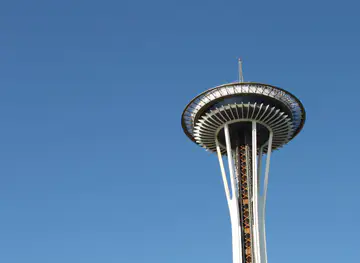
Queen Anne’s attractions range from the major cultural institutions of Seattle Center to smaller public spaces and viewpoints on the hill. At the lower edge, the Space Needle provides the neighbourhood’s defining silhouette, while the Museum of Pop Culture, Chihuly Garden and Glass and Pacific Science Center offer distinct approaches to music, popular culture, art, science and design. Climate Pledge Arena adds a large-scale sports and concert venue, and the Seattle Center Monorail remains both a practical link to downtown and a surviving feature of the 1962 world’s fair legacy. Higher up, Kerry Park is a compact viewpoint with broad outlooks over downtown, Elliott Bay and, in clear weather, Mount Rainier. Queen Anne Avenue North and nearby residential streets supply a quieter attraction: a walk through mature gardens, historic houses, local cafés and changing views created by the hill’s steep contours.
-
City park
Kerry Park
Discover Kerry Park, Seattle's scenic gem offering breathtaking views of the skyline and a perfect spot for relaxation and photography.
12 min walk · 1.0 km from neighbourhood centre
-
Park
Olympic Sculpture Park
Explore Olympic Sculpture Park, a stunning outdoor art museum in Seattle featuring large-scale sculptures and breathtaking waterfront views.
7 min drive · 2.4 km from neighbourhood centre
-
Tourist attraction
International Fountain
Discover the International Fountain in Seattle Center, where stunning water displays meet vibrant city life, creating unforgettable memories for every visitor.
5 min drive · 1.7 km from neighbourhood centre
-
City park
Bhy Kracke Park
Experience the tranquility and scenic beauty of Bhy Kracke Park, an urban oasis in Seattle's East Queen Anne, perfect for relaxation and outdoor activities.
12 min walk · 1.0 km from neighbourhood centre


Best landmarks in Queen Anne
Queen Anne’s landmarks express both its hilltop residential history and its role as a civic and cultural centre. The Space Needle is the most recognisable structure, built for the 1962 Century 21 Exposition and still defining Seattle’s skyline from many parts of the city. The Seattle Center Monorail, also created for the fair, connects the precinct with downtown and preserves a visible piece of that mid-century vision. Kerry Park is less monumental but highly symbolic, offering one of the city’s best-known elevated views towards downtown, Elliott Bay and Mount Rainier. On the upper hill, Queen Anne’s historic houses, churches and apartment buildings form a dispersed architectural landmark rather than a single monument. At the lower edge, Climate Pledge Arena and the surrounding Seattle Center buildings mark the neighbourhood’s continuing role in music, sport, science and public culture.
-
City park
Kerry Park
Discover the breathtaking views and serene ambiance of Kerry Park, a must-visit urban oasis in the heart of Seattle's Queen Anne neighborhood.
12 min walk · 1.0 km from neighbourhood centre
-
Event venue
The Ruins
Discover The Ruins, Seattle's premier event venue, blending elegance and charm in the heart of Queen Anne for unforgettable celebrations.
5 min drive · 1.6 km from neighbourhood centre
-
Park
Northeast Queen Anne Greenbelt
Discover the serene beauty of Northeast Queen Anne Greenbelt, a lush urban park in Seattle offering stunning views of Lake Union and extensive hiking trails.
12 min walk · 0.9 km from neighbourhood centre
-
Park
Betty Bowen Viewpoint
Experience stunning views of Seattle's skyline and the Space Needle at Betty Bowen Viewpoint, a tranquil oasis in Queen Anne's lush landscape.
15 min walk · 1.2 km from neighbourhood centre


Explore Queen Anne on the map
A handpicked selection of must-see spots in Queen Anne, mapped for you.
Best hotels in Queen Anne
Best restaurants in Queen Anne
Dining in Queen Anne changes noticeably between Uptown and the hilltop. Around Seattle Center, restaurants and cafés serve museum visitors, concert audiences and arena crowds, with a practical mix of quick meals, coffee and sit-down dining. Upper Queen Anne has a more residential rhythm centred on Queen Anne Avenue North, where neighbourhood restaurants, bakeries, cafés and takeaway counters serve local residents as well as visitors. The scene is varied rather than defined by one single cuisine, encompassing familiar American formats, international cooking and contemporary casual dining. Event schedules can make the lower district particularly busy, while the summit usually feels more like a local commercial street. Visitors interested in the area’s food culture should explore side streets near the avenue as well as the larger venues around Seattle Center, where dining is closely linked to the district’s arts and entertainment calendar.
-
Creole
Toulouse Petit Kitchen & Lounge
Experience vibrant Creole and Cajun flavors at Toulouse Petit Kitchen & Lounge in Seattle's Queen Anne neighborhood – perfect for any meal or occasion.
18 min walk · 1.5 km from neighbourhood centre
-
Restaurant
5 Spot
Discover the flavors of America at 5 Spot in Queen Anne - where delicious breakfasts meet vibrant brunches in a cozy atmosphere.
8 min walk · 0.6 km from neighbourhood centre
-
Grill
Buckley's On Queen Anne
Discover Buckley's On Queen Anne: A top-notch grill in Seattle serving mouthwatering burgers and classic American dishes in a vibrant setting.
6 min drive · 1.9 km from neighbourhood centre
-
Oyster Bar
Taylor Shellfish Oyster Bar
Discover the ultimate oyster experience at Taylor Shellfish Oyster Bar in Seattle's Queen Anne—where fresh meets flavor in every bite.
5 min drive · 1.6 km from neighbourhood centre


Best bars in Queen Anne
Queen Anne is not primarily a late-night club district, but evening life is sustained by Seattle Center performances, arena events, neighbourhood bars and restaurants. Uptown becomes busiest before and after concerts, sports fixtures, theatre programmes and museum visits, with crowds concentrated around Mercer Street, Queen Anne Avenue and the Seattle Center campus. Upper Queen Anne offers a quieter selection of pubs, wine bars and casual drinking places woven into the local commercial strip rather than a continuous nightlife zone. The atmosphere is therefore event-led at the bottom of the hill and residential above it. Visitors should expect transport demand and queues to rise around major performances, while late-night options become more limited away from the Seattle Center area. Respect for nearby residents matters, particularly when leaving venues and walking through the hilltop streets.
-
Bar
Queen Anne Beerhall
Discover the best local brews and a lively atmosphere at Queen Anne Beerhall in Seattle, perfect for beer lovers and social gatherings.
6 min drive · 1.9 km from neighbourhood centre
-
Grill
Buckley's On Queen Anne
Discover Buckley's On Queen Anne: A beloved grill and hamburger restaurant in Seattle's charming Queen Anne neighborhood, offering delicious American comfort food.
6 min drive · 1.9 km from neighbourhood centre
-
Pub
Streamline Tavern
Experience the best of Seattle's pub culture at Streamline Tavern, where local brews and hearty fare meet a vibrant atmosphere.
17 min walk · 1.4 km from neighbourhood centre
-
Brewpub
McMenamins Queen Anne
Experience the vibrant brewpub culture of Seattle at McMenamins Queen Anne, where craft beers and delicious food come together in a cozy atmosphere.
18 min walk · 1.4 km from neighbourhood centre


Best shops in Queen Anne
Shopping in Queen Anne is divided between the event-oriented retail around Seattle Center and the more local strip along Queen Anne Avenue North. Uptown offers practical shops, cafés and visitor-oriented purchases near museums, theatres and the arena, while the hilltop commercial area has independent boutiques, book and gift shops, salons, food businesses and everyday services. The neighbourhood is not a traditional market district, and its retail identity depends more on small-scale local commerce than on a single bazaar or department-store corridor. Queen Anne Avenue is the most useful place to browse, with side streets revealing additional businesses among residential blocks. During exhibitions and events, visitors may find design-led cultural merchandise around Seattle Center; elsewhere, shopping feels closely connected to the routines of the established residential community.
-
Shopping mall
Queen Anne Marketplace
Explore Queen Anne Marketplace: a vibrant Seattle shopping mall offering unique shops, delicious dining, and a taste of local culture.
18 min walk · 1.5 km from neighbourhood centre
-
Gift shop
Spacebase Gift Shop at the Space Needle
Explore the Spacebase Gift Shop at the Space Needle for unique Seattle souvenirs and local treasures that capture the Pacific Northwest spirit.
6 min drive · 2.0 km from neighbourhood centre
-
Gift shop
Queen Anne Frame & Gift
Discover Seattle's artistic spirit at Queen Anne Frame & Gift, where unique treasures and quality craftsmanship await every visitor.
5 min walk · 0.4 km from neighbourhood centre
-
 Clothing store
MILLIE
Explore Millie, a charming clothing boutique in Queen Anne, Seattle, offering unique fashion finds and a delightful shopping experience.
5 min walk · 0.4 km from neighbourhood centre


Queen Anne essentials
Getting There
Getting Around
Safety
Emergency Situations
Do's and Don'ts
Local Tips

From Eve
Local phrases worth knowing
You don't need to get them perfect. A few words go a long way, and locals appreciate the effort.
Basics
| English | Local | Say it |
|---|---|---|
| Hello | Hey | [hey] |
| Goodbye | See ya | [see ya] |
| Yes | Yeah | [yeah] |
| No | Nah | [nah] |
| Please/You're welcome | Please/No problem | [please/no problem] |
| Thank you | Thanks | [thanks] |
| Excuse me/Sorry | Oops/My bad | [oops/my bad] |
| How are you? | How's it going? | [how's it going?] |
| Fine. And you? | Good. You? | [good. you?] |
| Do you speak English? | You speak English? | [you speak English?] |
| I don't understand | I'm lost | [I'm lost] |
Eating & Drinking
| English | Local | Say it |
|---|---|---|
| I'd like to see the menu, please | Can I see the menu, please? | [can I see the menu, please?] |
| I don't eat meat | I'm vegetarian | [I'm vegetarian] |
| Cheers! | Cheers! | [cheers!] |
| I would like to pay, please | Check, please | [check, please] |
Emergencies
| English | Local | Say it |
|---|---|---|
| Help! | Help! | [help!] |
| Go away! | Leave me alone! | [leave me alone!] |
| Call the Police! | Call 911! | [call 911!] |
| Call a doctor! | Need a doctor! | [need a doctor!] |
| I'm lost | Lost | [lost] |
| I'm ill | Sick | [sick] |
Shopping
| English | Local | Say it |
|---|---|---|
| I'd like to buy... | I want to buy... | [I want to buy...] |
| I'm just looking | Just looking | [just looking] |
| How much is it? | How much? | [how much?] |
| That's too expensive | Too pricey | [too pricey] |
| Can you lower the price? | Can you do better? | [can you do better?] |
Time & Numbers
| English | Local | Say it |
|---|---|---|
| What time is it? | What's the time? | [what's the time?] |
| It's one o'clock | It's one | [it's one] |
| Half past (10) | Ten thirty | [ten thirty] |
| Morning | Morning | [morning] |
| Afternoon | Afternoon | [afternoon] |
| Evening | Evening | [evening] |
| Yesterday | Yesterday | [yesterday] |
| Today | Today | [today] |
| Tomorrow | Tomorrow | [tomorrow] |
| 1 | One | [one] |
| 2 | Two | [two] |
| 3 | Three | [three] |
| 4 | Four | [four] |
| 5 | Five | [five] |
| 6 | Six | [six] |
| 7 | Seven | [seven] |
| 8 | Eight | [eight] |
| 9 | Nine | [nine] |
| 10 | Ten | [ten] |
Transport & Directions
| English | Local | Say it |
|---|---|---|
| Where's a/the...? | Where is the...? | [where is the...?] |
| What's the address? | Address? | [address?] |
| Can you show me (on the map)? | Show me (on the map)? | [show me (on the map)?] |
| When's the next (bus)? | When's the next (bus)? | [when's the next (bus)?] |
| A ticket (to ....) | One ticket (to ....) | [one ticket (to ....)] |
History of Queen Anne
Indigenous Shorelines and Early Settlement
Queen Anne occupies land within the traditional territory of Coast Salish peoples, including the Duwamish, whose presence around Elliott Bay and the wider Seattle area predates the city’s development. During the nineteenth century, settlers, logging activity and expanding roads altered the hill and its lower slopes. The name Queen Anne emerged in the 1880s when developers associated the area’s fashionable houses with the Queen Anne architectural style. Although the hill was not conceived as a single uniform settlement, its elevated position and proximity to the growing waterfront made it attractive for residential expansion.
Streetcars and Hilltop Urban Growth
Queen Anne’s residential growth accelerated after the area became part of Seattle in the 1880s and gained more dependable links with the commercial centre. Streetcar connections helped make the steep hill accessible to commuters, encouraging substantial houses, apartment buildings, churches and local shops. Queen Anne Avenue developed as the main commercial route, while the upper slopes acquired the spacious streets and mature landscaping that still distinguish them. The neighbourhood’s social geography also began to diverge: the summit became predominantly residential, while industry, transport and denser urban development gathered nearer the waterfront and lower approaches.
The Regrade and a Changing Lower District
Major earth-moving projects reshaped the lower part of Queen Anne during the early twentieth century. The Denny Regrade removed much of Denny Hill east of the neighbourhood and altered routes between downtown, the waterfront and the base of Queen Anne. New streets and commercial development followed, while the hill itself retained its residential identity. The contrast between Upper Queen Anne’s established homes and the increasingly urban lower district became more pronounced. The area around Mercer Street and what is now Seattle Center later developed as a significant civic and entertainment zone, linking the neighbourhood to Seattle’s larger urban expansion.
Century 21 and the Uptown Cultural Precinct
The 1962 Century 21 Exposition transformed the lower neighbourhood by creating the grounds now known as Seattle Center. The Space Needle, monorail and other exhibition structures introduced a new civic symbol and established the area as a destination for science, culture and entertainment. After the fair, Seattle Center continued as a public campus rather than disappearing with the temporary exhibition. Museums, theatres, festivals and sports facilities expanded its role, while the surrounding lower district gradually adopted the name Uptown. Queen Anne therefore contains two overlapping historical identities: a long-established hilltop residential community and a nationally recognised cultural precinct at its southern edge.
Queen Anne in Photos
Browse through our photo collection highlighting the charm and character of the destination.
Neighbourhoods near Queen Anne
The closest neighbourhoods to Queen Anne, if you have time for more than one stop.
-

-
-


Swipe for more neighbourhoods
Explore more

Explore more of Seattle
Seattle blends Puget Sound scenery, coffee culture, music history and landmark architecture with museums, markets and urban adventures in Washington State.
Explore Seattle