Grossglockner High Alpine Road · Travel guide · Updated 2026

Majestic Journeys on the Grossglockner High Alpine Road

Discover the breathtaking views and engineering marvels of the Grossglockner High Alpine Road, Austria's most scenic drive through the heart of the Hohe Tauern National Park.

The Grossglockner High Alpine Road is a marvel of engineering and natural beauty. Spanning across the stunning Hohe Tauern National Park, this scenic route offers breathtaking views of Austria's tallest peak, the Grossglockner. As you drive along the winding roads, each turn reveals a new panorama of lush valleys, towering cliffs, and serene alpine meadows. The road itself is an attraction, with its expertly constructed pathways that make you feel at one with the surrounding landscape. Visitors can stop at numerous viewing platforms to soak in the incredible vistas. The Edelweiss-Spitze, the highest viewpoint accessible by car, provides a 360-degree view of more than thirty mountain peaks towering over 3,000 meters. Each season paints a different picture: the road is vibrant with wildflowers in summer, while autumn transforms the scenery into a golden spectacle. In winter, the snow-covered peaks offer a serene and magical experience. While driving, you can explore the various attractions along the route. The Kaiser-Franz-Josefs-Höhe is a must-visit with its visitor center and glacier views. Here, you can learn about the region's geology, wildlife, and the history of the Grossglockner High Alpine Road. For those interested in a more active experience, numerous hiking trails start from the road, leading you deeper into the untouched wilderness. Whether you are a nature lover, a history enthusiast, or simply looking for a picturesque drive, the Grossglockner High Alpine Road promises an unforgettable journey through one of Austria’s most iconic landscapes.

Explore the guide

What are you looking for in Grossglockner High Alpine Road?

Jump straight into the city guide by the kind of discovery you want first.

When is the best time to go to Grossglockner High Alpine Road?

Weather at a glance

Use the monthly temperature and precipitation trends to compare typical conditions across the year before planning city walks, museum days, and riverside exploring.

Temperature

°C

Precipitation

mm
Warmest monthsJun–Aug
Longest daylightJun–Aug
Driest periodJan–Dec

Explore places in Grossglockner High Alpine Road

    See all →

    Popular Experiences in Grossglockner High Alpine Road

    Top-rated options near you

    Mobile App
    Get the app

    Your all‑in‑one travel companion app

    Explore expert travel guides, compare and book tours, experiences, hotels, and more—all from the palm of your hand. Download now for seamless trip planning wherever your wanderlust takes you.

    Popular Hotels in Grossglockner High Alpine Road

    Top-rated options near you

    Practical planning

    Grossglockner High Alpine Road Essentials

    Core city planning details in the same structured guide format used across the Country/Region page language.

    How to Get There

    Grossglockner High Alpine Road is situated in Austria, connecting the states of Salzburg and Carinthia. The nearest major airports are Salzburg Airport (approximately 120 km away) and Innsbruck Airport (about 200 km away). From these airports, you can rent a car or use public transportation to reach the road. The journey by car offers the most flexibility and is highly recommended to fully appreciate the scenic route. Public buses also operate from nearby towns such as Zell am See and Lienz.

    Transportation

    Driving your own car or renting one is the most convenient way to explore Grossglockner High Alpine Road, allowing you to stop at various viewpoints and attractions along the way. Bicycles and motorcycles are also popular choices for traversing the road. Public transportation includes buses that run seasonally, usually from May to October. Parking areas are available at multiple points, but be prepared for limited space during peak tourist season.

    Currency and Payment

    The official currency in Austria is the Euro (EUR). Credit and debit cards are widely accepted along the Grossglockner High Alpine Road, especially at larger establishments, gas stations, and tourist attractions. However, it's advisable to carry some cash for smaller purchases or in case you encounter a remote location without card facilities. ATMs are available in major towns like Zell am See and Heiligenblut.

    Safety

    Grossglockner High Alpine Road is generally a safe destination for tourists. However, the area can experience sudden weather changes, so always check the forecast and road conditions before setting out. There are no specific high-crime areas targeting tourists, but standard safety precautions such as not leaving valuables in your car and being aware of your surroundings are recommended.

    Emergency Situations

    In case of emergencies, dial 112 for immediate assistance. The road is well-patrolled by local police and emergency services, especially during the tourist season. Medical facilities are available in nearby towns such as Zell am See and Heiligenblut. It is advisable to carry a first aid kit and have travel insurance that covers medical emergencies. For vehicle breakdowns, there are service stations along the route where help can be sought.

    Do's and Don'ts

    Fashion: Do dress in layers and wear sturdy footwear, as weather can change rapidly. Avoid wearing high heels or flip-flops. Religion: Do respect local customs and traditions, particularly when visiting religious sites like chapels along the route. Public Transport: Do use designated parking areas and be mindful of other tourists. Don't block access roads or viewpoints. Greetings: Do greet people with a friendly 'Grüß Gott' or 'Hallo'. A smile and eye contact go a long way. Eating & Drinking: Do try local Austrian delicacies at mountain huts and restaurants. Don't litter; always use designated trash bins.

    Local Tips

    To experience Grossglockner High Alpine Road like a local, consider stopping at lesser-known viewpoints and hiking trails. Visit early in the morning or late in the afternoon to avoid the crowds and enjoy the tranquility. Engage with local guides and rangers who can provide insights into the flora, fauna, and history of the area. Don't miss the Kaiser-Franz-Josefs-Höhe visitor center for panoramic views and educational exhibits.

    History of Grossglockner High Alpine Road

    Follow the city from Roman Londinium to its modern global identity through landmark moments that still shape the visitor experience.

    Origins and Conception

    The Grossglockner High Alpine Road, or Großglockner Hochalpenstraße, was conceived in the late 1920s as a means to boost tourism and provide employment during the Great Depression. Austrian engineer Franz Wallack led the project, envisioning a scenic route that would traverse the Hohe Tauern mountain range and offer unparalleled views of Austria's highest peak, the Grossglockner.

    Construction and Engineering Feats

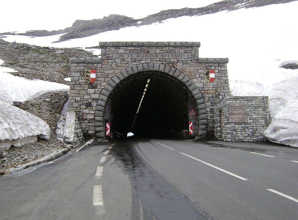
    Construction began in 1930 and was completed in 1935, involving over 3,000 workers. The project was a monumental engineering feat, requiring the excavation of over 870,000 cubic meters of earth and rock. Despite the harsh alpine conditions, the road was built without the use of heavy machinery, relying instead on human and animal labor. The 48-kilometer route includes 36 hairpin bends and ascends to a height of 2,504 meters at the Hochtor Pass.

    Opening and Early Tourism

    The road was officially opened on August 3, 1935, with a grand ceremony attended by Austrian dignitaries and international guests. Early tourists were captivated by the panoramic views, diverse flora and fauna, and the opportunity to experience the majesty of the Alps up close. The road quickly became a popular destination for motorists and cyclists alike.

    World War II and Post-War Reconstruction

    During World War II, the Grossglockner High Alpine Road suffered damage due to military activity and neglect. After the war, extensive repairs and improvements were undertaken to restore the road to its former glory. In the 1950s and 1960s, the road was widened and modernized to accommodate increasing traffic and meet safety standards.

    Cultural Significance and Tourism Today

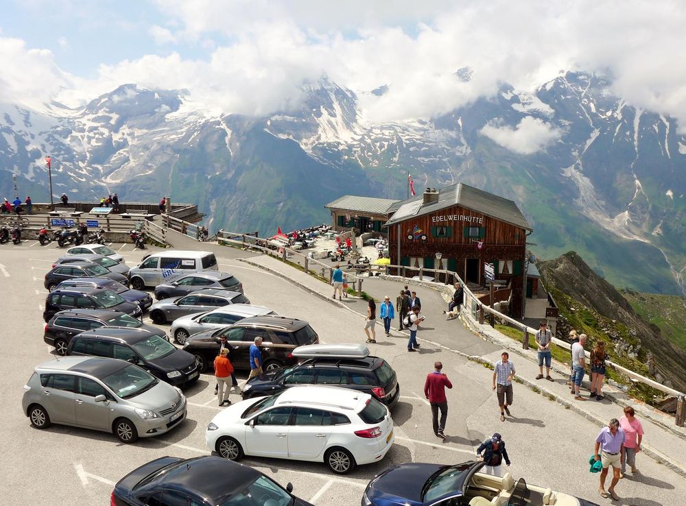
    Today, the Grossglockner High Alpine Road is not only a popular tourist attraction but also a symbol of Austrian resilience and ingenuity. It hosts over 900,000 visitors annually, offering a range of activities including hiking, cycling, and educational exhibits at the visitor center. The road has also inspired numerous works of art, literature, and photography, further cementing its place in Austrian cultural heritage.

    Environmental and Conservation Efforts

    In recent years, efforts have been made to balance tourism with environmental conservation. Initiatives such as the 'Alpine Nature Show' at the Kaiser-Franz-Josefs-Höhe and the preservation of local wildlife habitats aim to educate visitors about the importance of protecting this unique alpine ecosystem. The Grossglockner High Alpine Road continues to serve as a model for sustainable tourism in high-altitude environments.

    Phrasebook

    Local Phrases about Grossglockner High Alpine Road

    Browse practical local phrases by situation. Each group opens only when needed, keeping the guide tidy while preserving the full phrase set.

    6 phrase groups English + pronunciation
    Basics
    • HelloHallo
      [ha-loh]
    • GoodbyeAuf Wiedersehen
      [owf vee-der-zay-en]
    • YesJa
      [yah]
    • NoNein
      [nine]
    • Please/You're welcomeBitte
      [bih-teh]
    • Thank youDanke
      [dahn-keh]
    • Excuse me/SorryEntschuldigung
      [ent-shool-dee-gung]
    • How are you?Wie geht es Ihnen?
      [vee gayt es een-en]
    • Fine. And you?Gut. Und Ihnen?
      [goot oont een-en]
    • Do you speak English?Sprechen Sie Englisch?
      [shpre-khen zee eng-leesh]
    • I don't understandIch verstehe nicht
      [ikh fer-shteh-eh nikht]
    Eating & Drinking
    • I'd like to see the menu, pleaseIch möchte bitte die Speisekarte sehen
      [ikh merkhte bih-teh dee shpigh-kahr-teh zeh-en]
    • I don't eat meatIch esse kein Fleisch
      [ikh es-se kine flysh]
    • Cheers!Prost!
      [prohst]
    • I would like to pay, pleaseIch möchte bitte bezahlen
      [ikh merkhte bih-teh beh-tzah-len]
    Emergencies
    • Help!Hilfe!
      [hil-feh]
    • Go away!Geh weg!
      [gey vehg]
    • Call the Police!Rufen Sie die Polizei!
      [roo-fen zee dee po-lee-tzai]
    • Call a doctor!Rufen Sie einen Arzt!
      [roo-fen zee i-nen ahrts]
    • I'm lostIch habe mich verirrt
      [ikh hah-beh meekh feh-rit]
    • I'm illIch bin krank
      [ikh been krank]
    Shopping
    • I'd like to buy...Ich möchte gerne kaufen...
      [ikh merkhte gehr-neh kow-fen]
    • I'm just lookingIch schaue nur
      [ikh shou-eh noor]
    • How much is it?Wie viel kostet es?
      [vee feel kohs-tet es]
    • That's too expensiveDas ist zu teuer
      [dahs ist tso toy-er]
    • Can you lower the price?Können Sie den Preis senken?
      [kuh-nen zee den preys sen-ken]
    Time & Numbers
    • What time is it?Wie spät ist es?
      [vee shpet ist es]
    • It's one o'clockEs ist ein Uhr
      [es ist iyn oor]
    • Half past (10)Halb elf
      [halb elf]
    • MorningMorgen
      [mor-gen]
    • AfternoonNachmittag
      [nahk-mee-tahk]
    • EveningAbend
      [ah-bent]
    • YesterdayGestern
      [gehs-tern]
    • TodayHeute
      [hoy-tuh]
    • TomorrowMorgen
      [mor-gen]
    • 1Eins
      [ayns]
    • 2Zwei
      [tsvay]
    • 3Drei
      [dry]
    • 4Vier
      [feer]
    • 5Fünf
      [foonf]
    • 6Sechs
      [zeks]
    • 7Sieben
      [zee-ben]
    • 8Acht
      [ahkt]
    • 9Neun
      [noyn]
    • 10Zehn
      [tsayn]
    Transport & Directions
    • Where's a/the...?Wo ist ein/der...?
      [voh ist iyn/der]
    • What's the address?Was ist die Adresse?
      [vahs ist dee ah-dreh-seh]
    • Can you show me (on the map)?Können Sie mir das zeigen (auf der Karte)?
      [kuh-nen zee meer dahs tsee-gen (owf der kar-teh)]
    • When's the next (bus)?Wann kommt der nächste (Bus)?
      [vahn kohmt der nekh-ste (boos)]
    • A ticket (to ....)Eine Fahrkarte (nach ....)
      [iyn-eh fahr-kahr-teh (nahkh ....)]

    Explore Grossglockner High Alpine Road in Photos

    A quick visual tour through classic views, riverside landmarks, royal streets, and skyline moments.

    File:Grossglockner Hochalpenstrasse, Margaritzenstausee.jpg - Wikimedia  Commons
    File:Kaiser-Franz-Josefs-Höhe, 2014 (01).JPG - Wikimedia Commons
    File:Grossglockner and Pasterze glacier.jpg - Wikimedia Commons
    File:Edelweißspitze, 2014 (03).JPG - Wikimedia Commons
    Datei:Hochtor Tunnel, Großglockner Hochalpenstraße.JPG – Wikipedia
    File:Großglockner Hochalpenstraße 21082018 383.jpg - Wikimedia Commons
    Datei:Heiligenblut kirche2.jpg – Wikipedia
    File:20190624.Kaiser-Franz-Joseph-Höhe, Grossglockner.-051.jpg - Wikimedia  Commons

    Planning another trip?

    Continue exploring nearby destinations and classic AT city breaks after Grossglockner High Alpine Road.

    Select Currency

    Choose the currency you want prices to display in.