Dronningestenen Viewpoint, Almindingen Forest
Forest-framed viewpoint on a high Bornholm plateau, where the "Queen’s Stone" opens to sweeping vistas over southern fields and the far Baltic horizon.
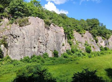
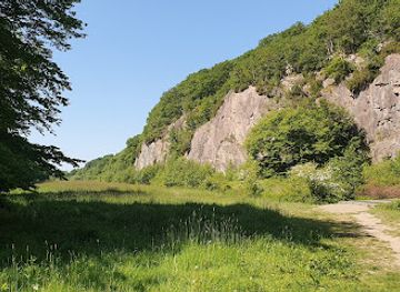
Set on a high plateau above Almindingen Forest north of Aakirkeby, Dronningestenen is a dramatic rock outcrop and viewpoint with sweeping vistas over southern Bornholm and the distant Baltic Sea. Reached via forest trails, the "Queen’s Stone" rewards the short hike with fresh pine-scented air, bird song and a classic Bornholm landscape of rolling fields, woods and sky. It is often combined with nearby sights such as Ekkodalen and Rytterknægten, making it a natural stop on a day exploring the island’s wild interior.
A brief summary to Dronningestenen
- Aakirkeby, 3720, DK
- Duration: 1 to 3 hours
- Free
-
Outdoor
- Mobile reception: 3 out of 5
- Monday 12 am-12 am
- Tuesday 12 am-12 am
- Wednesday 12 am-12 am
- Thursday 12 am-12 am
- Friday 12 am-12 am
- Saturday 12 am-12 am
- Sunday 12 am-12 am
Local tips
- Wear sturdy shoes; the approach uses forest trails with roots, rocks and occasional muddy patches, especially after rain.
- Bring water and snacks, as there are no services directly at Dronningestenen and limited options once you enter Almindingen.
- Combine the viewpoint with nearby Rytterknægten or Ekkodalen for a fuller picture of Bornholm’s inland landscape.
- Check the weather before setting out; clear days offer the best long-distance views towards the sea.
- In spring and summer, consider insect repellent for ticks and mosquitoes common in Danish forests.
For the on-the-go comforts that matter to you
- Information Boards
- Picnic Areas
- Trash Bins
- Seating Areas
Getting There
-
Car from Aakirkeby
From Aakirkeby, allow about 15–20 minutes by car to reach parking areas on the edge of Almindingen near the trailheads for Dronningestenen. Local roads are paved and well signposted towards the forest. Parking is generally free but can be limited in high summer, so arrive early if you plan to combine several sights in one day.
-
Bus and walk from Rønne
From Rønne, regional buses to Almindingen and the Aakirkeby area typically take 25–40 minutes depending on route and season, with standard Bornholm bus fares in the range of 25–50 DKK one way. Services run more frequently on weekdays and in summer. From the nearest forest stop, expect a 30–60 minute walk on signposted trails to reach Dronningestenen.
-
Cycling from Aakirkeby
Cycling from Aakirkeby into Almindingen is a popular option, taking roughly 20–30 minutes each way on gently hilly roads and forest tracks. There is no specific fee for bicycles, but you should bring lights and a repair kit, and be prepared for gravel sections once you enter the forest.
Dronningestenen location weather suitability
-
Clear Skies
-
Mild Temperatures
-
Any Weather
-
Cold Weather
Discover more about Dronningestenen
A Forest Plateau with a Royal Name
Dronningestenen sits on a high forested plateau in Almindingen, one of Denmark’s largest and most atmospheric woodlands, just north of Aakirkeby. Here the terrain rises to around 110 metres above sea level, enough to give a sense of height on an otherwise gentle island. The name means "the Queen’s Stone", and local lore ties it to royal visits and the long tradition of monarchs touring Bornholm’s interior. Whatever the exact origin, the name adds a touch of storybook flair to an already scenic spot. The setting is pure inland Bornholm: dense mixed woodland, rocky outcrops of granite and a patchwork of clearings that suddenly open onto far-reaching views. Dronningestenen is both a rock formation and a viewpoint, a natural balcony where the forest edge drops away and the landscape of southern Bornholm spreads out below.Wide Horizons over Southern Bornholm
From the vantage at Dronningestenen you look south across Vallensgård and out towards the coast. On clear days the horizon line is punctuated by the faint shimmer of the Baltic Sea, while closer at hand you pick out farmsteads, small woodlots and the low, undulating fields that characterize this part of the island. The contrast with the enclosing trees of Almindingen is striking: one moment you are in deep forest, the next you are standing in open light. Because the altitude here is modest but unobstructed, the view works in both broad strokes and fine detail. In spring and summer the greens stack in layers – dark conifers below, bright deciduous crowns nearby, pale fields in the distance. In autumn, the panorama becomes a warm tapestry of gold, copper and russet, while winter strips the land down to form, light and shadow.Walking Trails and Forest Atmosphere
Reaching Dronningestenen involves a walk on forest paths, often combined with routes that also pass Ekkodalen, Geddebæksfald and Rytterknægten. Waymarked trails weave through Almindingen, linking rocky viewpoints, small streams and older sites like the Gamleborg fortress plateau. Distances vary from short loops suitable for a relaxed stroll to longer circuits that fill most of a day outdoors. Underfoot the terrain is mostly forest track, with some rooted and rocky sections as you approach the viewpoint itself. The air smells of pine needles and damp earth, and the soundtrack is wind in the canopy, distant woodpeckers and the occasional rustle of roe deer. Even on busy days in high season, it is easy to step away from any hubbub and find a quiet pocket of woodland near the stone.Bornholm’s Inland Story
Almindingen has long been a focal point in Bornholm’s history, with traces of fortifications, royal interests and forest management shaping the landscape. Nearby Gamleborg is one of the island’s oldest strongholds, linked to the age of early Danish kings, while Rytterknægten carries a memorial tower celebrating a 19th-century royal visit. Dronningestenen fits naturally into this narrative of crowns, castles and cultivated woodland, even if its own "queen" is more a matter of legend than documented fact. What the site clearly expresses is the layered relationship between people and nature in the island’s interior. The forest around you has been carefully managed yet still feels decidedly wild, and the viewpoint underlines how central this high plateau is to understanding Bornholm’s geography, wedged between its rocky coasts and fertile southern plains.Planning Your Visit on the Plateau
A visit to Dronningestenen is easily folded into a wider exploration of Almindingen. Many walkers link it with Rytterknægten, Bornholm’s highest point at 162 metres, or drop down towards Ekkodalen’s dramatic escarpment and echoing valley. There are no ticket barriers or fixed opening hours at the stone itself; access is open, and simple facilities – such as rest spots or information boards – may be found at trailheads and nearby forest clearings rather than right at the viewpoint. Allow enough time not just for the walk there and back, but also to linger. The charm of Dronningestenen lies less in a single landmark rock and more in the cumulative experience: the gradual climb through trees, the sudden reveal of sky and distance, and the quiet sense of standing at the heart of Bornholm while looking out towards its edge.For the vibe & atmosphere seeker
- Scenic
- Tranquil
- Relaxing
- Adventurous
- Unique
For the architecture buff
- Parks & Gardens
- Viewpoints
For the view chaser and sunset hunter
- Iconic Views
- Panoramas
- Sunset Spots
For the social media creator & influencer
- Photo Spots
- Selfie Spots
- Reel-Friendly
- Architectural Shots
For the eco-conscious traveler
- Low Impact
- Public-Transport Accessible
- Leave-No-Trace Critical
- Wildlife Habitat
For the kind of experience you’re after
- Nature Escape
- Photowalk
- Adventure Photo Shoot
- Day Trip
- Roadtrip Stop
- Mindfulness
For how adventurous you want the journey to be
- Requires Hike
- Easy Access
Location Audience
- Family Friendly
- Senior Friendly
- Child Friendly
- Teen Friendly
- Solo Friendly
- Couple Friendly