Background

Midterpilt, High Point of Paradisbakkerne

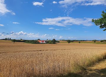
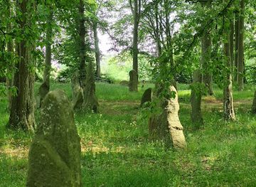
A modest stone cairn marking the highest point of Paradisbakkerne, Midterpilt is a quiet waypoint on Bornholm’s wildest woodland and heathland hiking routes.

★★★★★4.4 (5)

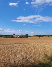
Midterpilt is the stone cairn that marks the **highest point of Paradisbakkerne** at 113 m above sea level, in the forested hills between Svaneke and Nexø on Bornholm. Reached via waymarked trails, this modest pile of stones is a quiet landmark within a rugged Ice Age landscape of rocky ridges, rift valleys and heather-clad slopes. It is less a standalone sight than a rewarding pause along one of Bornholm’s classic hiking routes.

Plan your visit

A brief summary to Midterpilt

Opening times, essentials, and a few local tips gathered into one calmer, easier-to-scan planning section.

Plan your visit

📍
Oksemyrevejen 502, 503, Svaneke, 3740, DK
💷
Free
🏛
Outdoor
📶
Mobile reception: 3 out of 5

Explore places near Midterpilt

    See all →

    Unlock the Best of Midterpilt

    Find tickets, tours with entry, and experiences available for this location.

    Buy tickets

    No tickets available

    Book tours with entry

    No tours with entry available

    Book tours without entry

    No tours without entry available

    Getting There

    Car from Svaneke

    From central Svaneke, driving to the main Paradisbakkerne trailhead near Klinteby typically takes about 10–15 minutes, following inland country roads. Parking at the marked lot is free or low cost; there is no vehicle access into the protected hills themselves, so you continue on foot from the lot. Trails from this access point form a three‑hour circuit that passes Midterpilt.

    Bus and walk from Nexø

    From Nexø, regional buses connect towards the inland stops closest to Paradisbakkerne in around 10–20 minutes, with standard single tickets generally in the range of 25–40 DKK depending on distance. Services run less frequently outside summer, so checking the timetable in advance is essential. From the nearest stop, expect a further 30–45 minutes of walking on minor roads and forest paths to reach the main trail network and continue on to Midterpilt.

    Cycling from Svaneke or Nexø

    Experienced cyclists can ride from either Svaneke or Nexø to the Paradisbakkerne trailhead in roughly 25–40 minutes, using small paved roads and signposted cycle routes. The approach includes some short but noticeable hills, and bikes must be left at the edge of the protected area, as cycling is not permitted on the narrow forest hiking tracks. This option is free apart from any bike rental costs in town, which commonly start around 100–150 DKK per day.

    For the on-the-go comforts that matter to you

    Information Boards
    Trash Bins
    Picnic Areas

    Local tips

    Wear sturdy walking shoes; trails around Midterpilt cross roots, rocks and occasional muddy patches even in dry periods.
    Bring water and snacks, as there are no facilities within Paradisbakkerne itself; treat Midterpilt as a remote forest stop.
    Stick to the marked hiking routes and respect the dawn‑to‑dusk access rules; the area is protected and partly privately owned.
    Combine Midterpilt with nearby sights like Rokkestenen and Gamleborg for a rewarding half‑day circuit through the Paradise Hills.
    In wet or cooler weather, pack an extra layer and light rain gear; the forest can feel noticeably cooler than the coast.

    Discover more about Midterpilt

    Bornholm’s Roof in the Paradise Hills

    Midterpilt is a simple stone cairn marking the highest point of Paradisbakkerne, the so‑called Paradise Hills in eastern Bornholm. At 113 metres above sea level, it is hardly an alpine summit, yet in the gently undulating landscape of the island this little rise feels like a natural roof. The cairn stands in a clearing of low vegetation, framed by mossy rock and light woodland, with glimpses of the surrounding ridges through the trees.Paradisbakkerne lies inland between the coastal towns of Svaneke and Nexø. The area’s compact scale means that within a short walk you move from shady forest to open heath, then to rock outcrops scarred by the last Ice Age. Midterpilt sits roughly in the middle of this protected landscape, giving it its name: the “middle cairn”.

    An Ice Age Landscape Under Your Feet

    The terrain around Midterpilt is a textbook example of glacial geology. Paradisbakkerne’s rounded hilltops and scattered boulders were sculpted by vast sheets of ice that once covered Bornholm. As the glaciers advanced and retreated, they carved deep rift valleys such as Ravnedal and left behind smoothed rock surfaces you can still feel with your hands.Today the forest and heath soften the scene, but the ground remains rough and uneven. Exposed granite, narrow notches and small marshy hollows appear beside the trail. The modest height of Midterpilt makes it accessible for most walkers, yet the constantly changing underfoot conditions keep the walk engaging.

    Waymarked Trails and Quiet Crossroads

    Midterpilt is not approached by roads but by a network of colour‑coded hiking trails that weave through Paradisbakkerne. These routes link several natural and cultural waypoints: the famous rocking stone Rokkestenen, the remains of Gamleborg hillfort, small lakes like Grydesø and damp valleys with ferns and berries.The cairn itself feels like a quiet crossroads. Paths converge briefly, then peel off towards Majdal, Ravnedal or the more remote parts of the hills. Signposts and markers keep navigation straightforward, yet there is a sense of being well away from towns and traffic. Stays are restricted to marked paths and limited to daylight hours to protect the area’s fragile nature and private ownership.

    Flora, Fauna and Seasonal Moods

    Around Midterpilt, the forest is home to rare insects, bats and birdlife that benefit from the mosaic of old woodland, open heath and rocky clearings. Overhead you may spot raptors circling, while in the undergrowth cranberries and blueberries thrive in late summer. The mixed vegetation and slight elevation create subtle shifts in light and temperature as you walk.Each season brings a different atmosphere. Spring adds fresh green to the birch and beech, summer brings warm, resin‑scented air and longer days, while autumn colours the forest floor and granite with russet tones. Even on cooler days, the shelter of the trees makes this a comfortable place to walk, as long as you are prepared for occasional wind and showers.

    Experiencing Midterpilt Along the Trail

    Most visitors meet Midterpilt as one stop on a longer circular hike of around three hours across Paradisbakkerne. The cairn provides a natural pause: a place to check the map, sip water and appreciate being in the centre of this hilly pocket of Bornholm. There are no built facilities here; the appeal lies in the simplicity of the marker and the quiet that surrounds it.Good footwear is essential, as roots, stone and sometimes damp patches are part of the experience. Families with active children often enjoy the small sense of achievement in “reaching the top”, while more seasoned walkers use Midterpilt as a reference point when linking several valleys and viewpoints into a full‑day outing.

    Respecting a Protected Corner of Bornholm

    Paradisbakkerne has been under nature protection since the late 19th century. Around Midterpilt, this means sticking to the signed paths, visiting only between early morning and sunset, and keeping a respectful distance from scattered farm buildings on the fringes of the hills. Motor traffic is banned inside the protected area.With a bit of care – carrying out all rubbish, keeping noise low and leaving plants and stones where they are – visitors help preserve both the natural habitats and the quiet, slightly wild character that makes this small cairn in the forest feel special.

    A brief summary to Midterpilt

    Use Midterpilt as your starting point for nearby food, family ideas, nightlife, and more local discoveries.

    Plan around the quieter times

    A quick look at seasonal patterns and peak visiting hours.

    Busiest months of the year

    Seasonality

    Busiest hours of the day

    Footfall
    Mobile App
    Get the app

    Your all‑in‑one travel companion app

    Explore expert travel guides, compare and book tours, experiences, hotels, and more—all from the palm of your hand. Download now for seamless trip planning wherever your wanderlust takes you.

    File:Hammershus ruin Bornholm Denmark 1.jpg - Wikimedia Commons

    More about Bornholm

    Explore Bornholm: Denmark's Baltic gem, offering stunning nature, rich history, and vibrant local culture. Perfect for nature lovers, history buffs, and food enthusiasts.

    Tell me more about Bornholm

    Select Currency

    Choose the currency you want prices to display in.