Rytterknægten & Kongemindet Tower, Bornholm
Bornholm’s modest summit in Almindingen Forest, where a royal memorial tower, whispering pines and modern trail facilities meet in a quietly atmospheric hilltop clearing.
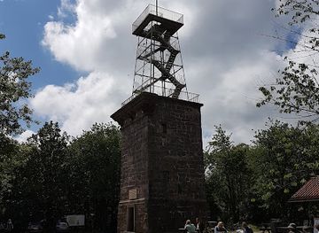
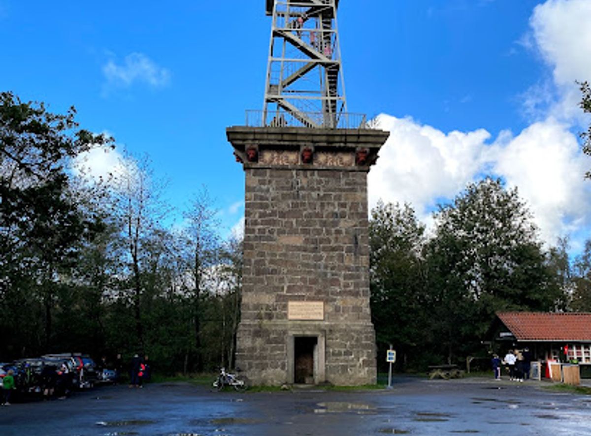
Set in the heart of Almindingen Forest near Aakirkeby, Rytterknægten is Bornholm’s highest point, crowned by the historic Kongemindet memorial tower. Raised in 1856 to honor a royal visit and later extended with steel scaffolding, it once offered sweeping views over the island, Sweden and Christiansø. Today the wooded summit is a peaceful forest escape, laced with walking and cycling trails, picnic spots and the new Trailcenter pavilion that supports outdoor adventures year-round.
A brief summary to Rytterknægten
- Aakirkeby, DK
- Duration: 1 to 3 hours
- Free
-
Outdoor
- Mobile reception: 3 out of 5
Local tips
- Bring sturdy walking shoes; forest paths around Rytterknægten can be uneven, muddy after rain and occasionally rooty despite the gentle gradients.
- Pack snacks and drinks, especially outside peak summer, as facilities nearby are limited and you are deep inside Almindingen Forest.
- Check current information on Kongemindet’s access; the steel extension has undergone renovation and viewing access may be restricted.
- Combine the summit with a loop via Ekkodalen or Gamleborg to turn a short stop into a rewarding half-day forest hike.
- Dress in layers even in summer; the wooded hilltop is often cooler and breezier than the coast, especially in the evening.
For the on-the-go comforts that matter to you
- Restrooms
- Drinking Water
- Seating Areas
- Sheltered Areas
- Picnic Areas
- Trash Bins
- Information Boards
- Visitor Center
Getting There
-
Car from Aakirkeby
From central Aakirkeby, driving to Rytterknægten via the roads through Almindingen typically takes 10–15 minutes. The route follows paved rural roads almost all the way, with a short stretch on narrower forest access roads near the end. There is usually free parking close to the summit area, but spaces are limited in high summer and during school holidays. No entrance fee is charged for visiting the hill or tower area.
-
Bus and short walk from Rønne
From Rønne, regional buses towards Aakirkeby and Nexø operate several times a day, with journeys to stops near Almindingen taking around 25–35 minutes. From the nearest forest stop you should expect an additional 20–30 minutes of walking on forest tracks to reach Rytterknægten, mostly on gentle terrain that may be uneven or muddy after rain. Normal regional bus tickets on Bornholm cost roughly 25–40 DKK one way, depending on distance and ticket type.
-
Cycling from Aakirkeby
Active visitors can cycle from Aakirkeby to Rytterknægten in about 25–40 minutes, depending on fitness and route choice. The ride uses a mix of smaller paved roads and forest gravel tracks with gentle but steady inclines as you approach the island’s highest point. There are no specific fees for accessing the forest by bike, but lights, helmets and weather-appropriate clothing are strongly recommended, and after rain some sections can be soft or slippery.
Rytterknægten location weather suitability
-
Clear Skies
-
Mild Temperatures
-
Cold Weather
-
Any Weather
Discover more about Rytterknægten
The highest point in Bornholm’s deep green heart
Rising to 162 meters above sea level, Rytterknægten sits in the middle of Almindingen, one of Denmark’s largest forests and the wild, wooded core of Bornholm. Dense spruce and deciduous trees cloak the bedrock, so the summit feels more like a forest clearing than a barren peak. The air is cool and resin-scented, birds flit between trunks, and soft forest paths radiate out towards nearby highlights such as Ekkodalen and Gamleborg. Despite its modest height, this is a place of quiet drama in otherwise low-lying Denmark. The sense of elevation is subtle but real: the light changes, the wind moves differently through the canopy, and on clear days gaps in the trees reveal glimpses across the island towards the Baltic Sea.Kongemindet – a royal story in granite and steel
At the summit stands Kongemindet, a granite memorial tower inaugurated in 1856 to commemorate King Frederik VII and Countess Danner’s visit to Bornholm a few years earlier. Designed by architect Gottlieb Bindesbøll and funded by local donations, the solid masonry is detailed with lion heads and a dedicatory plaque expressing the islanders’ loyalty to the monarch. As the forest slowly grew and swallowed the horizon, engineers added a steel superstructure in 1899, lifting the viewing platform to a total of 184 meters above sea level. The unusual twin staircases separated ascent and descent, creating a narrow but efficient viewing deck that, in clear weather, opened views towards Sweden and the tiny island of Christiansø offshore.Forest walks, viewpoints and a modern trail center
Today, the summit area is a compact hub for exploring Almindingen. Waymarked paths lead through mixed forest, over exposed rock and past glacial boulders, offering short strolls and longer hikes. The terrain is gently undulating rather than strenuous, making it accessible to most walkers with reasonable footwear. A contemporary addition is the Trailcenter Rytterknægten pavilion, a raised timber structure that acts as a gathering point for hikers, runners and mountain bikers. Here you find shelter, information, simple facilities and places to rest or tinker with a bike before heading back out onto the trails, all designed with an eye to low-impact, inclusive outdoor recreation.A name shaped by riders and a stone by the path
Rytterknægten translates roughly as “the rider’s squire”, a nod to a time when mounted nobles required assistance to get into the saddle. Local lore ties the name to a flat stone near the area where riders could mount without a human helper, using the rock as a natural stepping block. Over time, the evocative term came to denote the entire hilltop. This blend of royalty, folklore and forest gives the site a slightly old-world atmosphere. Granite, iron and moss sit side by side, telling stories that range from medieval horsemanship to 19th‑century patriotism and the technical ambitions of early observation towers.Calm woodland atmosphere and seasonal character
The mood on Rytterknægten shifts with the seasons. In spring the forest floor brightens with new growth and birdsong; summer brings lush foliage and cool shade on hot days. Autumn lays down coppery leaves and opens fleeting views between thinning branches, while winter can feel stark and meditative, with bare trunks, frost and perhaps a dusting of snow. Even when the tower structure is partially closed for renovation, the surrounding hill and forest remain inviting. Benches, picnic spots and clearings provide places to pause, listen to the wind in the trees and experience Bornholm from a quieter, more reflective vantage point than the island’s famous cliffs and beaches.For the vibe & atmosphere seeker
- Tranquil
- Zen
- Scenic
- Unique
- Casual
For the design and aesthetic lover
- Rustic Designs
For the architecture buff
- Historic
- Landmarks
- Parks & Gardens
- Viewpoints
- Sacred Sites
For the view chaser and sunset hunter
- Iconic Views
- Panoramas
- Sunrise Spots
- Sunset Spots
For the social media creator & influencer
- Photo Spots
- Selfie Spots
- Architectural Shots
- Reel-Friendly
For the eco-conscious traveler
- Eco-Friendly
- Low Impact
- Protected Area
- Public-Transport Accessible
- Leave-No-Trace Critical
- Locally Managed
- Wildlife Habitat
For the kind of experience you’re after
- Mindfulness
- Meditation Spot
- Spiritual / Energy Spot
- Cultural Heritage
- Photowalk
- Adventure Photo Shoot
- Nature Escape
- Roadtrip Stop
- Day Trip
For how adventurous you want the journey to be
- Easy Access
Location Audience
- Family Friendly
- Senior Friendly
- Child Friendly
- Teen Friendly
- Solo Friendly
- Couple Friendly
- Solo Female Friendly