Background

Slaggård Banke Bronze Age Ridge

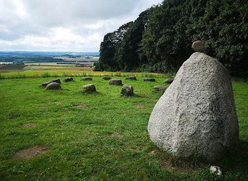
Bronze Age barrows, big-sky vistas and a stargazing shelter on a glacial ridge above the Gudenå Valley, just beyond the village of Østbirk in Central Jutland.
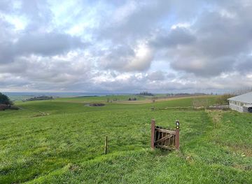
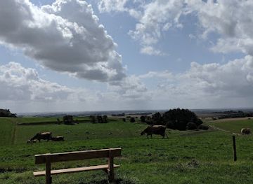
4.3

Ancient barrows on a dramatic Jutland ridge

Slaggård Banke is a gently elongated ridge in the countryside between Underup and Østbirk, its rounded summit rising to roughly 100–109 meters above sea level. Here the land suddenly buckles into steep, undulating slopes, the legacy of powerful Ice Age forces that left a pronounced terminal moraine across Central Jutland. On this natural high ground, people of the Bronze Age chose to bury their elite, raising prominent earthen mounds that still define the skyline today. The hill hosts a group of large, protected burial mounds, often counted as nine major barrows along the crest. Grassy and time-softened, they nevertheless stand clearly apart from the surrounding farmland. Their position on the ridge was no accident: from here, the dead would “overlook” the land, and their monuments would be visible from far across the valley, a constant reminder of power, ancestry and belief.

Landscapes shaped by ice and human hands

Walking onto the banke, you step into a landscape where geology and archaeology intertwine. The ridge itself was sculpted by retreating glaciers, leaving a spine of elevated ground flanked by smaller knolls and dips. Over millennia, farming communities cleared the slopes, grazed livestock and traced paths across the contours, gradually turning the area into a mosaic of fields, meadows and pockets of woodland. Today, the terrain remains pleasingly varied. Short grass, patches of heath-like vegetation and scattered shrubs cloak the higher ground, while lower areas can feel more enclosed and sheltered. In spring and summer, wildflowers and buzzing insects add colour and sound. From the tops of the barrows, you can read the larger geography: the Gudenå Valley stretching away, the low horizon of Ejer Bjerge and, in clear weather, a glimpse toward Horsens Fjord and the distant sea.

Quiet paths, viewpoints and stargazing shelter

Slaggård Banke is small enough to explore in an hour yet rich enough to reward lingering. A network of informal and waymarked tracks loops across the ridge, allowing you to wander among the mounds, circle their bases, and find your own favourite viewpoint. The gradients are gentle to moderate, suitable for most walkers with basic mobility, though some slopes can be slippery when wet. On one side of the ridge you find a distinctive two-level shelter structure that doubles as a simple stargazing tower. Built in timber and tucked into the landscape, it offers basic overnight accommodation for those who book it in advance through local channels, together with a raised platform that makes it easier to lie back and scan the night sky. On clear evenings, with limited light pollution from nearby villages, constellations and the Milky Way can be surprisingly vivid.

Atmosphere of calm, history and open skies

What defines Slaggård Banke more than anything is its spacious calm. There is no grand visitor centre, only modest signage and a few information boards explaining the history and nature of the ridge. The sounds that dominate are wind in the grass, skylarks overhead and the occasional tractor in the distance. It is as much a place for simple pleasures—spreading out a picnic blanket, watching clouds roll over the valley, walking a dog on a blustery day—as it is for contemplating Bronze Age customs. The open views lend themselves naturally to photography. Low, grazing light at sunrise or late afternoon emphasises the contours of the mounds and the folds of the land, while mist in the valley below can create a floating-island effect around the ridge. In winter, a dusting of snow picks out every hollow and hump; in autumn, golden fields and coppery hedgerows frame the barrows in warm tones.

Respecting a protected cultural landscape

Slaggård Banke is legally protected as a cultural heritage site, and the burial mounds are safeguarded against disturbance. Visitors are free to walk around and over the grassy barrows, but digging, camping directly on the mounds, lighting open fires or moving stones and turf is not permitted. Paths and access points are managed in cooperation with local landowners, who continue to farm the surrounding fields. Simple amenities—such as a fire ring near the shelter, occasional benches and marked trail posts—are designed to keep the footprint low. Rubbish facilities may be sparse, so carrying out everything you bring in is essential to preserving the area’s character. Treated with care, this modest hill continues to offer a rare combination of accessible nature, tangible prehistory and big-sky views in the middle of Jutland.

Local tips

  • Wear sturdy shoes: the ridge is short but can be uneven, with slippery grass on steeper slopes in wet or frosty weather.
  • Bring layers and a windproof jacket; the exposed hilltop catches the breeze even on otherwise mild days.
  • Pack water and snacks, as there are no shops on-site and only limited facilities near the shelter area.
  • If you plan to use the shelter or fire ring, check local booking requirements in advance and always follow posted rules.
  • For stargazing, choose a clear, moonless night and let your eyes adjust for 15–20 minutes to see the best detail.
widget icon

Buy tickets

    No tickets available

Book tours with entry

    No tours available

Book tours without entry

    No tours available

A brief summary to Slaggård Banke

  • Monday 12 am-12 am
  • Tuesday 12 am-12 am
  • Wednesday 12 am-12 am
  • Thursday 12 am-12 am
  • Friday 12 am-12 am
  • Saturday 12 am-12 am
  • Sunday 12 am-12 am

Getting There

  • Car from Horsens

    Driving from Horsens to Slaggård Banke takes around 25–35 minutes via local country roads. The route crosses gently rolling farmland and small villages before reaching Østbirk and Naldalvej. Parking is informal along the approach road or near the shelter area and is generally free, but spaces are limited and the surface may be grassy or unpaved, so take care in very wet conditions.

  • Regional bus and walk

    From Horsens, regional buses run to Østbirk with typical journey times of 30–45 minutes and single tickets usually in the range of DKK 30–60, depending on time and route. Services are less frequent in evenings and on weekends. From the bus stop in Østbirk, allow about 20–30 minutes to walk out through the village edge and along Naldalvej to the ridge on mostly paved and then country lanes.

  • Cycling from Østbirk and nearby villages

    Slaggård Banke is well suited to a short cycle trip from Østbirk or nearby hamlets. Expect 10–25 minutes of easy to moderate cycling each way on small rural roads with light traffic but no dedicated bike lanes. Surfaces are generally good, yet can be exposed to wind, and visibility may be reduced in fog or heavy rain, so lights and high-visibility clothing are recommended.

Popular Experiences near Slaggård Banke

Popular Hotels near Slaggård Banke

Select Currency