Background

Ejer Bavnehøj & Genforeningstårnet

A modest Danish hill with a mighty horizon, Ejer Bavnehøj blends reunification history, beacon legends and big-sky views into an easy, rewarding countryside stop.

4.3

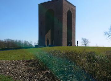
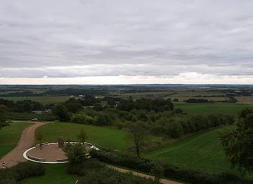
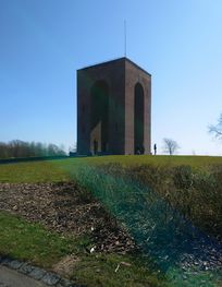
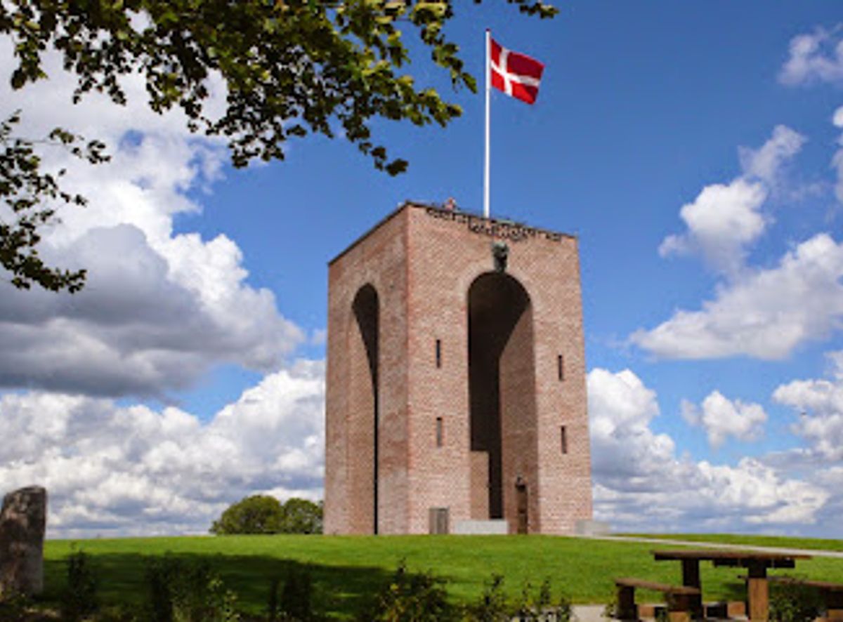
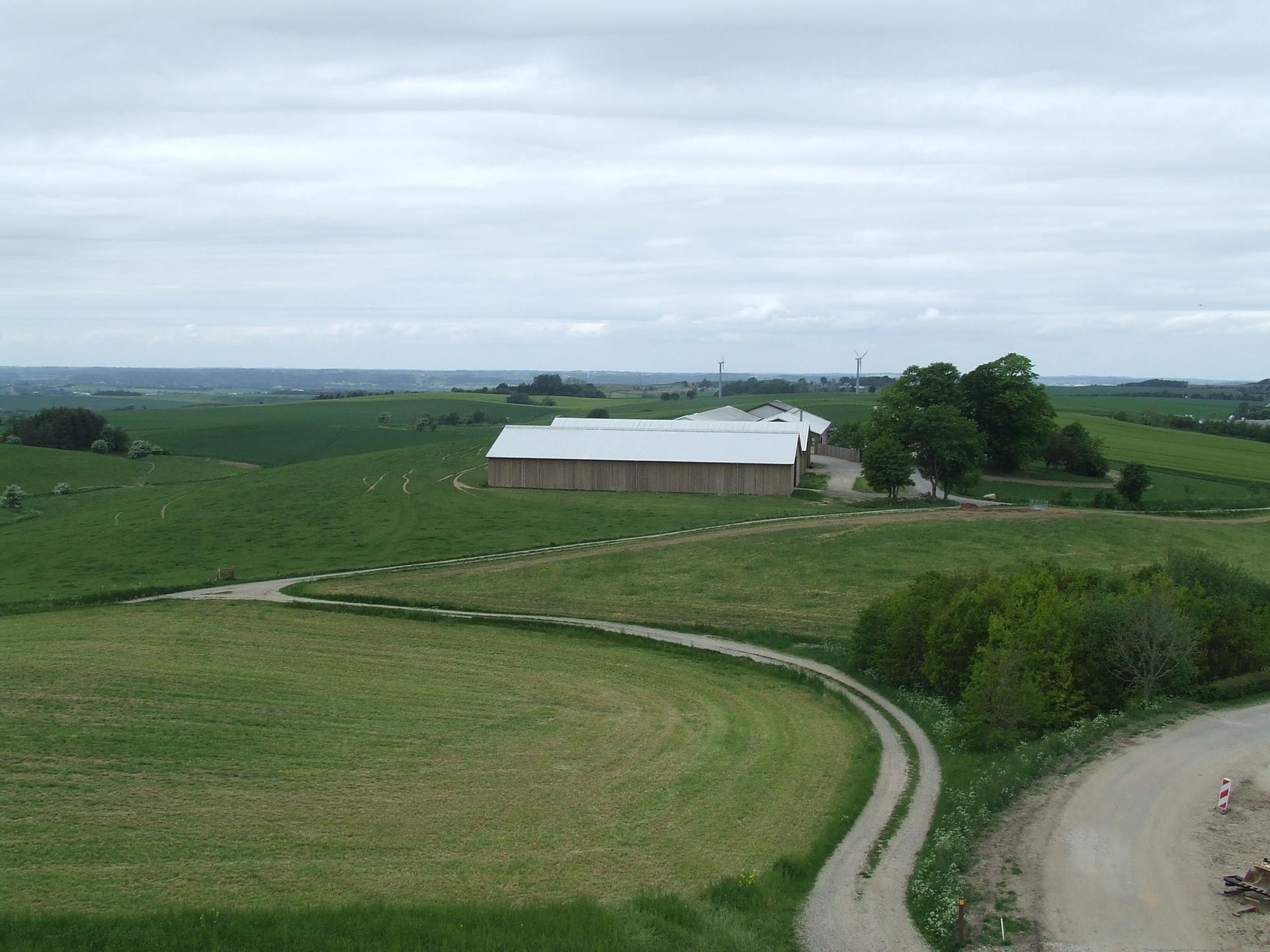
Ejer Bavnehøj rises from the rolling Jutland countryside as one of Denmark’s highest natural points, crowned by the brick Genforeningstårnet, a 1924 memorial to the reunification of Southern Jutland. From this modest but wind-swept summit you get big-sky panoramas over glacially carved hills and farmland, easy paths, picnic spots, a small kiosk in season, and a short walk to neighbouring Møllehøj, officially Denmark’s highest point. It is an atmospheric pause on a road trip, blending quiet views, national history, and simple outdoor time.

A brief summary to Ejer Bavnehøj

  • Ejer Bavnehøjvej 4, Skanderborg, 8660, DK
  • +4540189357
  • Visit website
  • Duration: 0.5 to 2 hours
  • Free
  • Environment icon Outdoor
  • Mobile reception: 4 out of 5

Local tips

  • Bring a contactless payment method or small amount of Danish kroner for the modest tower entrance fee, which is collected electronically at the base.
  • Wear windproof layers even in summer; the exposed summit catches more breeze and can feel significantly cooler than lower, sheltered areas.
  • Allow extra time to follow the short path over to Møllehøj, Denmark’s highest measured point, for a gentle ridge walk between the two summits.
  • Pack water and light snacks outside kiosk opening hours, especially if visiting early or in the off-season when services may be limited.
  • For photographs, aim for late afternoon or early evening when the low sun adds texture to the rolling moraine landscape around the hill.
widget icon

Getting There

  • Car from Aarhus

    From central Aarhus, driving to Ejer Bavnehøj typically takes 35–45 minutes via the main motorway towards Skanderborg before turning into smaller country roads. The route is fully paved and straightforward for standard vehicles. There is a free car park very close to the summit, but spaces can feel busy on sunny weekends and holiday afternoons, so aim for earlier or later in the day.

  • Car from Skanderborg town

    From Skanderborg, the drive usually takes 15–20 minutes along regional roads through gently hilly farmland. The final approach is on narrower local roads but still suitable for ordinary cars in all seasons under normal conditions. Parking at the site is free and within a short, slightly uphill walk of the tower, making this one of the most convenient access options.

  • Taxi from Skanderborg

    If you arrive in Skanderborg by train or bus, a local taxi to Ejer Bavnehøj generally takes 15–20 minutes each way. Typical fares for the one-way trip fall in the range of 200–300 DKK depending on time of day and traffic, with higher costs in evenings and weekends. Agree the approximate price before departure and note that there are no taxi ranks at the hilltop, so arrange your return pick-up in advance.

  • Cycling from nearby villages

    Confident cyclists can reach Ejer Bavnehøj from surrounding villages such as Ejer or Hovedgård in roughly 30–60 minutes, depending on starting point and fitness. Expect rolling terrain with some steady, if modest, climbs as you approach the plateau. Roads are public and shared with cars, so high-visibility clothing and lights are advisable, and the ride is best in daylight and in dry, non-windy conditions.

Ejer Bavnehøj location weather suitability

  • Weather icon Clear Skies
  • Weather icon Mild Temperatures
  • Weather icon Cold Weather
  • Weather icon Any Weather
  • Weather icon Windy Conditions
  • Weather icon Hot Weather

Unlock the Best of Ejer Bavnehøj

Buy tickets

    No tickets available

Book tours with entry

    No tours available

Book tours without entry

    No tours available

Discover more about Ejer Bavnehøj

Hilltop where Danish history meets open sky

Ejer Bavnehøj is a broad, grassy summit in the hills south of Skanderborg, rising to around 170 metres above sea level and long regarded as one of Denmark’s very highest natural points. The landscape is gentle rather than dramatic, but the sense of height is real: fields and woods fall away in all directions and the horizon feels unusually far for this otherwise low-lying country. At the very top stands the red-brick Genforeningstårnet, completed in 1924 to commemorate the reunification of Southern Jutland with Denmark after the First World War. Its sturdy, almost fortress-like lines reflect the interwar years’ sober pride, while commemorative stones and inscriptions on the site quietly anchor the hill in the national story of loss in 1864 and return in 1920.

Beacon hill in an ancient glacial landscape

Long before memorial towers and boundary commissions, this rounded ridge served as a warning post. The name “Bavnehøj” comes from old beacon fires once lit here to signal approaching danger across the countryside. Standing on the open plateau, it is easy to see why: the hill commands wide views and is visible from far away when the air is clear. Geologically, the area is a showcase of the last Ice Age. The high plateau was shaped by advancing and retreating glaciers, which pushed and folded the ground into ridges and depressions. From the top you look out over a classic moraine landscape, dotted with lakes and patchwork fields. On very clear days the view stretches astonishing distances across eastern Jutland, underlining how even modest height can transform perspective in Denmark.

The tower, views and simple hilltop pleasures

Visiting Ejer Bavnehøj is straightforward and low-key. The summit is open, grassy and largely treeless, with paths leading gently up towards the tower. For a small fee you can climb inside the Genforeningstårnet, where narrow stairs lead to an upper platform with an even broader panorama and a more immediate feel for the wind and weather. Around the base of the tower there is space for picnics, short wanders and unhurried sky-gazing. Information boards typically explain the site’s history and geology, helping you decode what you see in the distance. Benches and simple facilities make it an easy place to pause on a longer journey, with the mood shifting from bright and breezy on sunny days to atmospheric and almost austere in low clouds or winter light.

Linking to Møllehøj and the surrounding high points

Just a short walk from the tower, a waymarked path leads over open fields towards Møllehøj, officially measured as Denmark’s highest natural point by a few extra centimetres. The difference in height is imperceptible on foot; instead, the walk feels like a gentle ridge ramble between two rounded tops. Along the way you cross farmland, pass small markers and gain a broader sense of this plateau as one connected highland rather than isolated peaks. Other nearby summits such as Yding Skovhøj add to the quiet rivalry over “highest point” honours. Together they form a compact cluster of hills that reward slow exploration, whether on foot, by bike or as short detours from a wider Jutland journey. Ejer Bavnehøj functions as the most accessible gateway to this upland pocket.

Accessible countryside with a contemplative atmosphere

Despite its rural setting, the hilltop is arranged to be welcoming to many types of visitors. Paths are relatively even, and the final approach from the parking area is short, making it manageable for families, older travellers and many wheelchair users. In season, a kiosk near the summit sells simple snacks and drinks, adding to the feeling of a small, self-contained outing rather than a major excursion. The overall atmosphere is calm and contemplative. There are no loud attractions, only wind in the grass, distant farm sounds and occasional music from the hill’s speakers at set times. It is a place to stretch your legs, trace the contours of Danish history in stone and brick, and let your gaze roam across an unexpectedly expansive horizon.

Busiest months of the year

Busiest hours of the day

Popular Experiences near Ejer Bavnehøj

Popular Hotels near Ejer Bavnehøj

Select Currency