Background

Vidåslusen (Højer New Sluice)

A powerful meeting of river, marsh and Wadden Sea where modern floodgates, vast skies and distant islands tell the story of life on Denmark’s tidal edge.

4.4

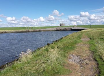
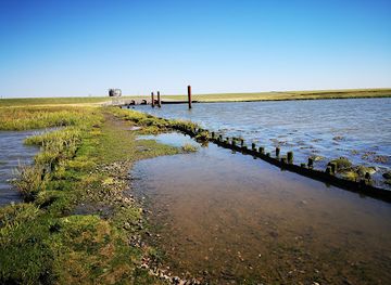
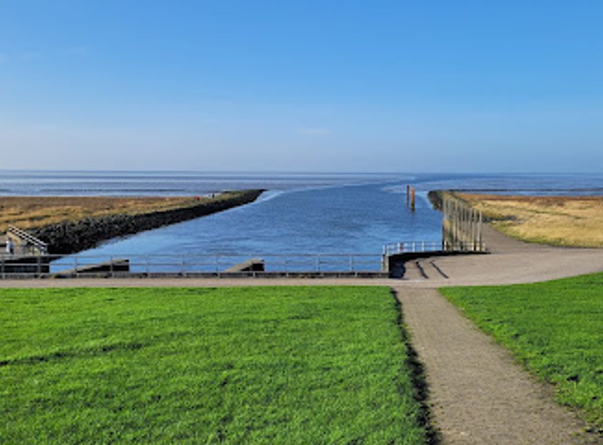
Vidåslusen guards the meeting point of the Vidå River and the Wadden Sea at the very edge of Denmark’s marshlands near Højer. Completed in 1981, this robust flood-control sluice of three concrete chambers and wooden gates protects the low-lying Tøndermarsken while offering sweeping views over dikes, tidal flats and distant islands such as Rømø and Sylt. It is an atmospheric spot to sense the power of tides, watch birdlife and trace the long story of humans living with the sea.

A brief summary to Vidåslusen

  • Slusevej, Højer Municipality, 6280, DK
  • Duration: 0.5 to 2 hours
  • Free
  • Environment icon Outdoor
  • Mobile reception: 4 out of 5
  • Monday 12 am-12 am
  • Tuesday 12 am-12 am
  • Wednesday 12 am-12 am
  • Thursday 12 am-12 am
  • Friday 12 am-12 am
  • Saturday 12 am-12 am
  • Sunday 12 am-12 am

Local tips

  • Time your visit around a tide change so you can see the contrast between exposed mudflats and high water, and watch how the sluice interacts with the shifting levels.
  • Bring binoculars or a zoom lens: the area is rich in birdlife and you can often pick out Rømø and Sylt on the horizon in clear weather.
  • Dress in layers and windproof clothing even in summer; the open marshes and dike tops can feel significantly cooler and windier than inland.
  • Combine the sluice with nearby walks towards Højer or Emmerlev Klev to experience different perspectives on the marsh and sea defences.
  • If you are interested in local history and engineering, consider joining a guided tour in season, which often covers the sluice, dikes and Wadden Sea heritage.
widget icon

Getting There

  • Car from Tønder

    From Tønder town centre, reaching Vidåslusen by car typically takes around 15–20 minutes, following the local road network west through Højer toward the dike. Expect a distance of roughly 12–15 km on paved roads. There is free parking close to the sluice, but spaces can fill up on busy weekends and during bird migration seasons.

  • Bus and short walk from Højer

    Regional buses connect Tønder and Højer on weekdays, with journeys usually taking 20–30 minutes. From Højer, it is a longer but straightforward walk of about an hour across flat terrain along the canal and dikes to the sluice. Surfaces are mostly paved or compacted paths, suitable for most walkers but exposed to wind and weather.

  • Bicycle from Højer and nearby villages

    Cycling from Højer to Vidåslusen takes about 20–30 minutes on flat ground, following minor roads and dike paths used by local traffic and cyclists. The terrain is easy but very open, so wind can significantly affect the effort. There is informal space to leave bicycles near the sluice, and combining the trip with longer marshland routes is popular in mild weather.

Vidåslusen location weather suitability

  • Weather icon Clear Skies
  • Weather icon Windy Conditions
  • Weather icon Mild Temperatures
  • Weather icon Cold Weather
  • Weather icon Hot Weather

Unlock the Best of Vidåslusen

Buy tickets

    No tickets available

Book tours with entry

    No tours available

Book tours without entry

    No tours available

Discover more about Vidåslusen

Where River, Sea and Marshlands Meet

Vidåslusen sits where the Vidå River empties into the Wadden Sea, on the outer edge of the wide Tøndermarsken marshes west of Højer. Standing on the dike you look out over flat land, endless sky and a tidal landscape that can be dry sea floor one moment and a broad, glittering water surface a few hours later. The sense of space is striking, with the horizon cut only by distant dikes, grazing sheep and, on a clear day, the silhouettes of the North Sea islands. This is part of the Wadden Sea National Park and UNESCO World Heritage landscape, an intricate mosaic of mudflats, salt marsh and channels sculpted by tides and storms. The sluice is both a piece of heavy engineering and a viewpoint into this constantly changing environment.

A Modern Sluice with Deep Historical Roots

The Vidåsluice, often called Højer New Sluice, was completed in 1981 as part of a major reinforcement of sea defences along this exposed coastline. It consists of three large concrete chambers, each fitted with two massive wooden gates that can be opened or closed depending on water levels in the river and the sea. When the tide is low, water from the marshes can drain out; when the North Sea rises or storms threaten, the gates are shut to hold the sea back. A short distance inland lies the older Højer Sluse from 1861, built together with an earlier dike. That 19th‑century structure served a double purpose: protecting reclaimed land and giving ships with masts access to Højer’s small harbour via the canal. The new sluice took over the main flood‑control role, while the old one remains as a second line of defence and a visible reminder of generations of struggle against storm surges.

Experiencing the Tides and the Weather

Visiting Vidåslusen is as much about atmosphere as it is about engineering. On calm days you may hear little more than wind in the grass and the calls of waders and geese feeding on the mudflats. At high tide, waves slap against the concrete and timber; at low tide, channels snake across exposed seabed. Cloud shadows race across the fields, and the light can shift from silver‑grey to warm gold within minutes. The nearby marshes are famous stopovers for migrating birds, and the skies can fill with flocks in spring and autumn. Interpretation boards in the area often explain this birdlife and the delicate ecology of the Wadden Sea. Paths and embankments around the sluice make it easy to stroll a little, find a bench and simply watch the tide turn.

Traces of Trade, Shipping and Local Life

Although today Vidåslusen is mainly associated with flood protection and nature, this stretch of coast also has a strong maritime and trading history. Before modern roads, Højer’s old sluice and harbour connected inland towns with the island of Sylt and the wider North Sea world. Steamships once departed from near here, linking spa resorts and cities further south. The new sluice, dikes and pumping systems reflect a different era, when the priority became large‑scale land reclamation and secure agriculture in the fertile but flood‑prone marshes. For local communities, the structure embodies security: a visible barrier against the devastating floods that have shaped stories and memories along this coast for centuries.

Walking Routes and Quiet Observation Points

Vidåslusen also forms a natural stop on longer walks through the marsh landscape. Well‑marked routes connect Højer, the inner dikes and viewpoints like Emmerlev Klev, often combining paved sections with firm gravel paths. Benches and simple seating areas dotted along the embankments invite you to pause with a thermos, scan the horizon for Rømø and Sylt, or simply enjoy the strong, salty air. Whether you come for half an hour or linger much longer, the experience is unhurried. There are no rides or loud attractions here, just the slow drama of tide and weather, the solid presence of the sluice and the feeling of standing on the thin line between land and sea.

Busiest months of the year

Busiest hours of the day

Popular Experiences near Vidåslusen

Popular Hotels near Vidåslusen

Select Currency