Background

Slaggård Banke Burial Mounds and Ridge Landscape

Bronze Age burial mounds on a quiet Jutland ridge, with gentle trails, far-reaching views and a nearby stargazing shelter for atmospheric nights under the sky.

★★★★★4.3 (57)

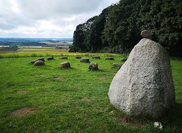
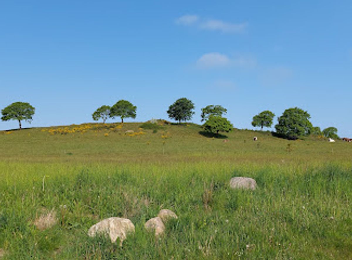
Slaggård Banke, just outside Østbirk in Central Jutland, is a gently rolling ridge strewn with Bronze Age burial mounds, open fields and pockets of woodland. This protected cultural landscape combines quiet walking trails, far-reaching views toward the Gudenå valley and a palpable sense of prehistory. Simple waymarked paths, a distinctive shelter-and-stargazing tower nearby and scattered information boards make it a rewarding stop for nature lovers and history-minded walkers alike.

Plan your visit

A brief summary to Slaggård Banke

Opening times, essentials, and a few local tips gathered into one calmer, easier-to-scan planning section.

Plan your visit

📍
Naldalvej 5, Ostbirk, 8752, DK
🕒
Duration: 1 to 3 hours
💷
Free
🏛
Outdoor
📶
Mobile reception: 4 out of 5

Explore places near Slaggård Banke

    See all →

    Unlock the Best of Slaggård Banke

    Find tickets, tours with entry, and experiences available for this location.

    Buy tickets

    No tickets available

    Book tours with entry

    No tours with entry available

    Book tours without entry

    No tours without entry available

    Getting There

    Car from Horsens

    From Horsens town centre, driving to Slaggård Banke near Østbirk typically takes 25–35 minutes via regional roads through rolling countryside. The route is straightforward, with paved two-lane roads almost all the way. Parking is usually possible on or near Naldalvej by the site entrance and is generally free, but spaces are informal and can be limited on fine weekends. There are no tolls or special permits required.

    Regional bus from Horsens

    Regional buses link Horsens and Østbirk in about 35–50 minutes, with services running roughly every hour during weekdays and less frequently in the evening and on Sundays. A standard adult single ticket usually costs around 35–50 DKK, depending on zones. From the Østbirk bus stop, expect an additional 20–25 minutes of walking on village and country lanes to reach the ridge, along gently undulating terrain suitable for most walkers.

    Cycling from Østbirk and surroundings

    If you are staying in or near Østbirk, cycling to Slaggård Banke is a pleasant option, typically taking 10–20 minutes from the village centre. Roads in the area are mostly quiet but shared with cars and agricultural vehicles, so lights and high-visibility gear are advisable, especially in low light. There are no dedicated bike racks at the site; most cyclists lock their bikes discreetly to a fence or leave them off the verge near the entrance.

    For the on-the-go comforts that matter to you

    Seating Areas
    Information Boards
    Trash Bins

    Local tips

    Wear sturdy, waterproof footwear; paths can be soft and muddy after rain, especially on meadow sections between the mounds.
    Bring water and snacks, as there are no shops or cafés directly at the site; facilities are found back in Østbirk.
    If you plan to use the shelter and stargazing tower, check local booking rules in advance, as overnight stays may require reservation.
    Visit in early morning or late afternoon for softer light that highlights the contours of the barrows and the ridge.
    Respect the protected burial mounds: stay off the tops where requested and avoid damaging vegetation or moving stones.

    Slaggård Banke location weather suitability

    Catch the right light and the right mood, whether you want a bright city moment or a more cinematic evening visit.

    Weather icon
    Any Weather
    Weather icon
    Clear Skies
    Weather icon
    Mild Temperatures
    Weather icon
    Cold Weather
    Weather icon
    Hot Weather

    Discover more about Slaggård Banke

    Ancient Ridge Above the Jutland Farmland

    Slaggård Banke rises as a long, undulating ridge south of Vestbirk and east of the Gudenå valley, its profile marked by rounded Bronze Age burial mounds that punctuate the skyline. Standing here, you look out over patchwork fields, hedgerows and farmsteads, with the ridge itself forming a natural stage for thousands of years of human activity. The landscape feels both modest and monumental: low hills under a big sky, yet layered with the weight of time. The banke is part of a wider old cultural environment where agriculture, ancient monuments and later forest planting coexist. Grassy paths and farm tracks weave between open slopes and small groves, revealing new angles on the mounds and the surrounding countryside as you walk.

    Bronze Age Barrows and Stories of the Dead

    The rounded humps crowning Slaggård Banke are prehistoric barrows, raised some 3,000 years ago as burial places for local elites. Their position on the ridge was no accident: elevated ground symbolised status and ensured that the dead remained visible to the living, watching over routes that once threaded through this part of Jutland. Although the individual graves are closed to visitors, their forms tell a clear story. Some mounds stand singly on small knolls, others group together like a silent family above the fields. A few show subtle signs of old excavations, reminders of early antiquarian interest and the fragile nature of such sites, which today are protected under heritage law.

    Walking Through Woods, Meadows and Art

    Slaggård Banke is best experienced on foot. Waymarked trails lead through light woodland, across meadow-like clearings and along the crest of the ridge, with gentle gradients that suit most walkers. Underfoot, surfaces shift between grass, soil and occasionally gravel, and in wet weather the low-lying patches can feel soft and muddy. In some sections, local art initiatives have placed sculptural pieces and playful interventions in the forest, giving the walk a subtle, open-air gallery character. A curve in the path might suddenly frame a mound between tree trunks, or a clearing may reveal both a barrow and an artwork sharing the same quiet space.

    Night Skies and the Stargazing Shelter

    Close to the ridge, a two-storey shelter doubles as a small stargazing tower, offering a simple yet imaginative way to stay overnight in the landscape. Built in timber and tucked into the terrain, it provides basic sleeping platforms and an upper level where openings frame the night sky. On clear evenings, light pollution is low enough that constellations, planets and sometimes the hazy band of the Milky Way become part of the experience. Owls, rustling leaves and distant farm sounds become the soundtrack, while the silhouettes of the barrows fade into darkness below.

    Seasonal Moods and Subtle Wildlife

    The character of Slaggård Banke shifts gently with the seasons. Spring brings fresh beech leaves, birdsong and wildflowers along the ditches. Summer paints the fields in gold and green, with heat shimmering over the mounds. In autumn, mist clings to the valley while the ridge breaks into sunlight, the trees glowing in copper and rust tones. Winter strips the landscape back to its contours, making the shape of each barrow especially clear. Birdlife is present more by sound than spectacle: skylarks above the fields, finches in hedges, occasional birds of prey circling on thermals. Small mammals, insects and a variety of grasses and wild plants add to the quiet richness of this semi-managed, semi-wild environment.

    A Quiet Pause in Central Jutland

    Despite its deep history, Slaggård Banke remains an understated place. There are few built facilities beyond information signs, simple seating in spots, and the shelter area further along the ridge. This low-key setup suits the site: the lack of noise and commercial activity amplifies the sense of stepping briefly outside everyday life. For many visitors, the appeal lies in combining a short, contemplative walk with a picnic or a longer ramble linking nearby woods and streams. Whether you come for archaeology, views or just a peaceful hour in the open, the ridge offers a compact but evocative window into Denmark’s prehistoric heartland.

    Plan around the quieter times

    A quick look at seasonal patterns and peak visiting hours.

    Busiest months of the year

    Seasonality

    Busiest hours of the day

    Footfall
    Mobile App
    Get the app

    Your all‑in‑one travel companion app

    Explore expert travel guides, compare and book tours, experiences, hotels, and more—all from the palm of your hand. Download now for seamless trip planning wherever your wanderlust takes you.

    Fil:Klokketårn i Nordby (Samsø, Danmark).JPG - Wikipedia, den frie  encyklopædi

    More about Samso

    Samsø: Explore Denmark's eco-friendly island, rich in natural beauty, culinary delights, and cultural heritage.

    Tell me more about Samso

    Select Currency

    Choose the currency you want prices to display in.