

Snake River Canyon Travel Guide - Free Web & App
Your ultimate guide to Snake River Canyon. Discover top landmarks, proposed trips, and local tips. Free on the web or via the Evendo companion app.


Snake River Canyon in Idaho offers basalt cliffs, Shoshone Falls, Perrine Bridge, scenic hikes and river views near Twin Falls for outdoor travellers.
A Canyon Cut Through the Snake River Plain
Snake River Canyon is a dramatic volcanic gorge in southern Idaho, best known around Twin Falls where the Snake River runs between dark basalt cliffs and drops over nearby Shoshone Falls. The canyon is not a single compact park but a long, varied landscape associated with the river and its steep rims, with the most developed visitor facilities concentrated around Twin Falls and the Perrine Bridge. Roads, viewpoints, paths and parks provide access to selected sections, while other stretches retain a more rural character.Read more about Snake River Canyon
Waterfalls, Cliffs and River Landscapes
Twin Falls and the Canyon Experience
When is the best time to visit Snake River Canyon?
Best: May–June, September · 21–27°C| Month | High (°C) | Rainfall (mm) |
|---|---|---|
| January | 3 | 30 |
| February | 5 | 25 |
| March | 10 | 25 |
| April | 16 | 25 |
| May (best) | 21 | 25 |
| June (best) | 27 | 20 |
| July | 32 | 15 |
| August | 31 | 15 |
| September (best) | 26 | 20 |
| October | 18 | 25 |
| November | 8 | 30 |
| December | 4 | 30 |
Getting to and around Snake River Canyon
How to get there
Transportation
Best attractions in Snake River Canyon
The principal attractions cluster around Twin Falls. Shoshone Falls is the signature sight, where the Snake River plunges over a broad basalt rim, while nearby Dierkes Lake offers a developed waterside recreation area separate from the main river channel. Perrine Bridge crosses the canyon north of the city and is a renowned viewpoint for the gorge, BASE jumping and seasonal birdwatching, although visitors should remain in designated public areas. Centennial Waterfront Park provides access to the river corridor and views beneath the bridge, while the adjacent Snake River Canyon Rim Trail follows sections of the upper gorge. Auger Falls Heritage Park preserves a more rugged stretch of canyon landscape with trails through basalt terrain and riverside vegetation. The Evel Knievel jump site adds a modern adventure-history dimension. Further along the river, rural sections become less serviced, so visitors should treat Twin Falls’ developed attractions and the wider canyon as distinct experiences.
-
Tourist attraction
Evel Knievel Snake River Canyon Jump Site
Discover the iconic Evel Knievel Snake River Canyon Jump Site in Twin Falls, Idaho, where adventure history meets breathtaking natural beauty.

Best landmarks in Snake River Canyon
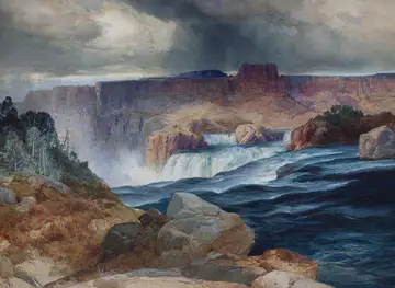
Shoshone Falls is the defining natural landmark, a wide waterfall formed where the Snake River crosses resistant basalt near Twin Falls; its volume changes with seasonal water conditions and upstream management. Perrine Bridge is the canyon’s most recognisable modern structure, spanning the gorge and linking the city’s developed rim with a celebrated adventure-sports setting. The surrounding basalt cliffs, layered lava surfaces and steep river walls are landmarks in geological as well as visual terms, revealing the volcanic history of the Snake River Plain. The Evel Knievel jump site marks the canyon’s place in twentieth-century popular culture, while the river itself remains the central geographical feature tying together waterfalls, parks, trails and riparian habitat. These landmarks occur mainly in the Twin Falls section, rather than representing a single built precinct across the entire canyon.
-
Park
Shoshone Falls Park
Experience the breathtaking beauty of Shoshone Falls Park, where nature's wonders await in the heart of Idaho's scenic landscapes.
-
Bridge
Perrine Memorial Bridge
Discover Idaho's stunning landscapes at Perrine Memorial Bridge, a must-visit tourist attraction known for its breathtaking views and rich history.
-
Park
Thousand Springs State Park - Malad Gorge Unit
Explore Thousand Springs State Park - Malad Gorge Unit, a captivating state park in Idaho featuring stunning landscapes, hiking trails, and vibrant natural springs.
-
Park
Snake River Canyon Rim Trail
Explore the breathtaking beauty of the Snake River Canyon Rim Trail in Twin Falls, Idaho, a scenic haven for outdoor lovers and nature enthusiasts.


Explore Snake River Canyon on the map
Plan your trip on one map. See where the top attractions, landmarks, restaurants and hotels are, and book hotels and experiences in a few clicks.
Best hotels in Snake River Canyon
Best restaurants in Snake River Canyon
Dining is concentrated in Twin Falls rather than along the canyon rim itself. The city offers the broadest choice of independent restaurants, cafés, bakeries, pubs and familiar national-style venues, making it the practical place to eat before or after visiting Shoshone Falls and the waterfront parks. Regional menus reflect southern Idaho’s agricultural economy, with potatoes and other irrigated produce prominent in local food supply, while beef, dairy products and trout are also characteristic of the wider inland Northwest. Farm shops and food producers around the Magic Valley may offer seasonal produce and packaged regional goods, but opening arrangements vary. Visitors staying in smaller communities or exploring rural stretches should carry provisions rather than expect a restaurant beside a viewpoint, trailhead or river access point.
-
Restaurant
Elevation 486
Experience breathtaking views and exquisite cuisine at Elevation 486 in Twin Falls - where every meal is complemented by nature's beauty.
-
American
Idaho Joes
Experience delicious American cuisine at Idaho Joe's in Twin Falls - where hearty breakfasts meet warm hospitality.
-
Grill
Scooter's Chillin' -N- Grillin'
Discover delicious comfort food at Scooter's Chillin' -N- Grillin', where great flavors meet fun times in Twin Falls.
-
Italian
Johnny Carino's
Savor authentic Italian flavors at Johnny Carino's in Twin Falls – where every dish tells a story of tradition and taste.


Best nightclubs in Snake River Canyon
Snake River Canyon itself has little evening entertainment infrastructure, and most visitors spend the night in Twin Falls, where pubs, breweries, casual bars and restaurants provide the main after-dark options. The atmosphere is generally relaxed and regional rather than centred on a dedicated nightlife district, with activity depending on individual venues and local events. Traditional social life in the surrounding communities is similarly based around restaurants, bars and community occasions rather than large clubs. The canyon’s parks, trails and viewpoints are not a substitute for organised nightlife, and visitors should check current local arrangements if seeking live music or special events. Outside Twin Falls, evening choices become considerably more limited, particularly in rural stretches of the Snake River corridor.
-
Bar
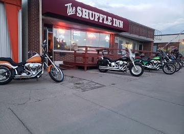
The Shuffle Inn
Discover a cozy bar experience at The Shuffle Inn in Twin Falls, Idaho, offering delicious drinks and a warm atmosphere for all.
-
Bar
Klover Club
Experience the vibrant nightlife at Klover Club in Twin Falls, where great ambiance, friendly vibes, and signature cocktails await.

Get your free copy of our complete guide to Snake River Canyon, delivered straight to you.
Everything on this page, from attractions and restaurants to essentials and local phrases, in one PDF you can read offline, print or share.
Already have an account? Sign in
Your Snake River Canyon guide is ready.
We'll send it to · Not you? Sign out

Getting your guide ready…
We are putting together a fresh copy of the Snake River Canyon guide. This can take up to a minute.
This can take a few moments. If your browser asks, choose Allow so the download can start. You'll find the guide in your Downloads folder.
Nothing happened? Download it again
Sorry, the guide is taking longer than usual. Please try again in a minute, or get it by email instead.
Snake River Canyon essentials
Currency and Payment
Safety
Emergency Situations
Do's and Don'ts
Local Tips
From Eve
Local phrases worth knowing
You don't need to get them perfect. A few words go a long way, and locals appreciate the effort.
Basics
| English | Local | Say it |
|---|---|---|
| Hello | Howdy | [haw-dee] |
| Goodbye | See ya | [see yuh] |
| Yes | Yup | [yuhp] |
| No | Nah | [nuh] |
| Please/You're welcome | Please/You're welcome | [pleez/yer welcome] |
| Thank you | Thanks | [th-anks] |
| Excuse me/Sorry | Pardon me | [par-dun me] |
| How are you? | Howdy | [haw-dee] |
| Fine. And you? | Fine. How 'bout you? | [f-ine. how bout yuh] |
| Do you speak English? | Ya speak English? | [yuh speak ing-glish] |
| I don't understand | I ain't gettin' it | [I aint get-tin it] |
Eating & Drinking
| English | Local | Say it |
|---|---|---|
| I'd like to see the menu, please | I'd like to see the grub list, please | [I'd like to see the grub list, please] |
| I don't eat meat | I ain't eatin' meat | [I aint eat-tin meat] |
| Cheers! | Cheers! | [cheers] |
| I would like to pay, please | I'd like to settle up, please | [I'd like to settle up, please] |
Emergencies
| English | Local | Say it |
|---|---|---|
| Help! | Help! | [Help!] |
| Go away! | Git! | [Git!] |
| Call the Police! | Call the Sheriff! | [Call the Sheriff!] |
| Call a doctor! | Call Doc! | [Call Doc!] |
| I'm lost | I'm turned around | [I'm turned around] |
| I'm ill | I'm feeling poorly | [I'm feeling poorly] |
Shopping
| English | Local | Say it |
|---|---|---|
| I'd like to buy... | I reckon I'll buy... | [I reckon I'll buy...] |
| I'm just looking | I'm just browsin' | [I'm just browsin'] |
| How much is it? | How much fer that? | [How much fer that?] |
| That's too expensive | That's too steep | [That's too steep] |
| Can you lower the price? | Can ya knock some off? | [Can ya knock some off?] |
Time & Numbers
| English | Local | Say it |
|---|---|---|
| What time is it? | What's the hour? | [What's the hour?] |
| It's one o'clock | It's one | [It's one] |
| Half past (10) | Half past (10) | [Half past (10)] |
| Morning | Mornin' | [Mornin'] |
| Afternoon | Afternoon | [Afternoon] |
| Evening | Evenin' | [Evenin'] |
| Yesterday | Yest'day | [Yest'day] |
| Today | Today | [Today] |
| Tomorrow | Tomorrah | [Tomorrah] |
| 1 | One | [One] |
| 2 | Two | [Two] |
| 3 | Three | [Three] |
| 4 | Four | [Four] |
| 5 | Five | [Five] |
| 6 | Six | [Six] |
| 7 | Seven | [Seven] |
| 8 | Eight | [Eight] |
| 9 | Nine | [Nine] |
| 10 | Ten | [Ten] |
Transport & Directions
| English | Local | Say it |
|---|---|---|
| Where's a/the...? | Where's a/the...? | [Where's a/the...?] |
| What's the address? | What's the addy? | [What's the addy?] |
| Can you show me (on the map)? | Can you show me (on the map)? | [Can you show me (on the map)?] |
| When's the next (bus)? | When's the next (bus)? | [When's the next (bus)?] |
| A ticket (to ....) | A ticket (to ....) | [A ticket (to ....)] |
History of Snake River Canyon
Basalt and the Snake River Plain
The canyon’s foundations belong to the volcanic history of the Snake River Plain, where repeated basalt eruptions spread extensive lava flows across southern Idaho. Later erosion by the Snake River and its tributaries cut through these resistant layers, producing the dark cliff faces and stepped geological profiles visible around Twin Falls. The canyon is therefore the result of long geological processes rather than a single event, and exposed rock along the rim provides a readable record of changing lava surfaces and river incision.
Indigenous Homelands and River Use
The Snake River corridor has long been part of the homelands and travel landscape of Indigenous peoples, including the Shoshone and Bannock peoples. The river supplied water, fish, plants and routes through an otherwise arid region, while falls and rapids shaped movement along the gorge. European-American accounts and later settlement often renamed or reframed places that already had deep Indigenous histories. Visitors should understand the canyon as a living cultural landscape rather than an empty wilderness encountered only after modern development.
Settlement and Irrigation
Euro-American settlement expanded in the late nineteenth and early twentieth centuries as irrigation transformed parts of southern Idaho’s dry Snake River Plain into productive farmland. Twin Falls became a major regional centre, and engineered diversion works and hydroelectric development altered the relationship between the river, agriculture and the canyon. These changes helped support towns and farms but also mean that water levels at features such as Shoshone Falls can vary according to season, precipitation and managed irrigation flows.
Twin Falls and the Rise of Tourism
The growth of Twin Falls brought roads, bridges, parks and viewpoints to the canyon rim, making the gorge increasingly accessible to visitors. Shoshone Falls became the area’s leading scenic attraction, while the river corridor acquired a wider reputation for dramatic scenery and outdoor recreation. The Perrine Bridge, completed in the 1970s, strengthened the connection between the city and the canyon and became a prominent landmark in its own right.
Adventure and Conservation Today
The canyon entered popular adventure culture through Evel Knievel’s unsuccessful 1974 rocket-powered jump attempt, launched from a site near the south rim east of the present Perrine Bridge. In recent decades, trails, waterfront parks and protected open spaces have encouraged recreation while highlighting the need to manage erosion, habitat and public safety. Modern visitors encounter a landscape shaped simultaneously by volcanic geology, irrigation, urban growth, conservation work and the continuing use of the river corridor.
Snake River Canyon in Photos
Browse through our photo collection highlighting the charm and character of the destination.
Cities in Snake River Canyon
The towns and cities of Snake River Canyon, and the easiest places to base yourself.

Swipe for more cities
Neighbouring destination travel guides
The closest destinations to Snake River Canyon, if you have time for more than one.
-
-

-

-

-


Swipe for more destinations
Explore more

Explore more of Magic Valley
Explore Idaho's Magic Valley for Snake River canyons, waterfalls, fossil beds, springs, farm-country landscapes and the cultural history of southern Idaho.
Explore Magic Valley
Explore more of Idaho
Idaho: Discover the Gem State's stunning landscapes, vibrant cities, and outdoor adventures. From majestic mountains to serene lakes, experience the natural wonders of Idaho.
Explore Idaho