

Lake Superior Travel Guide - Free Web & App
Your ultimate guide to Lake Superior. Discover top landmarks, proposed trips, and local tips. Free on the web or via the Evendo companion app.


Lake Superior, Minnesota reveals the North Shore, Split Rock Lighthouse, waterfalls, boreal forests, rocky beaches and four-season outdoor adventure.
Water, Forest and Shoreline
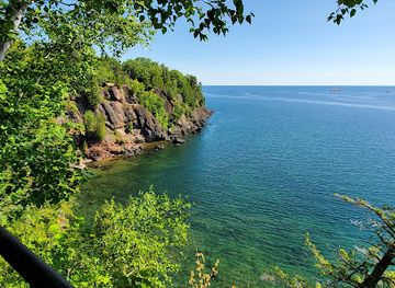
Lake Superior forms Minnesota’s northeastern edge, where the lake’s cold, expansive waters meet the North Shore’s rocky headlands, boreal forests and steep river valleys. Within Minnesota, the most travelled stretch runs from Duluth to the Canadian border, with Highway 61 linking harbour communities, state parks, waterfalls, overlooks and trailheads. The lake itself is vast enough to create its own weather, and its shoreline changes continually from wave-polished cobble beaches to dark volcanic cliffs and sheltered coves.Read more about Lake Superior
North Shore Communities
Heritage and Outdoor Life
When is the best time to visit Lake Superior?
Best: June–August · 23–26°C| Month | High (°C) | Rainfall (mm) |
|---|---|---|
| January | -2 | 30 |
| February | 0 | 25 |
| March | 5 | 35 |
| April | 11 | 50 |
| May | 17 | 65 |
| June (best) | 23 | 80 |
| July (best) | 26 | 90 |
| August (best) | 25 | 90 |
| September | 20 | 80 |
| October | 13 | 60 |
| November | 6 | 50 |
| December | -2 | 40 |
Getting to and around Lake Superior
How to get there
Transportation
Best attractions in Lake Superior
Minnesota’s Lake Superior attractions are spread along the North Shore rather than concentrated in one centre. Duluth provides a starting point with the Lake Superior Maritime Visitor Center, the Aerial Lift Bridge and waterfront views of the working harbour. Along Highway 61, Gooseberry Falls State Park combines river waterfalls with shoreline scenery, while Split Rock Lighthouse State Park and the historic lighthouse offer one of the coast’s most recognisable settings. Tettegouche State Park leads inland and towards high overlooks, rugged valleys and Lake Superior viewpoints, and Temperance River and Cascade River state parks add waterfalls, bridges and forest walks. Further north, Grand Marais has harbour and arts-centre appeal, while Grand Portage National Monument explains the historic canoe route and fur trade. Inland routes reach the Sawtooth Mountains, whose lakes and forests provide a contrasting landscape to the open lake.
-
State park
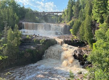
Gooseberry Falls State Park
Discover the breathtaking beauty of Gooseberry Falls State Park, a must-visit destination for nature lovers and outdoor enthusiasts in Minnesota.
-
 History museum
Split Rock Lighthouse
Discover the majestic Split Rock Lighthouse, where maritime history meets stunning views on the shores of Lake Superior.
-
State park
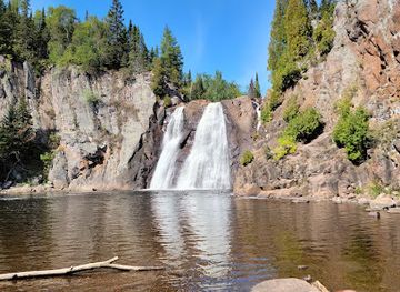
Tettegouche State Park
Discover the natural beauty and adventure of Tettegouche State Park, where stunning landscapes meet diverse outdoor activities along Lake Superior's North Shore.
-
Tourist attraction
Presque Isle Park
Discover the breathtaking landscapes and serene beauty of Presque Isle Park in Marquette, Michigan, a perfect destination for nature lovers and outdoor enthusiasts.
Explore Lake Superior on the map
Plan your trip on one map. See where the top attractions, landmarks, restaurants and hotels are, and book hotels and experiences in a few clicks.
Best hotels in Lake Superior
Best restaurants in Lake Superior
Food along the Minnesota North Shore reflects port life, northern forests, farming communities and the lake’s strong regional identity. Duluth has the widest choice, from cafés and bakeries to restaurants near the waterfront and neighbourhoods away from the harbour. Smaller communities such as Two Harbors, Silver Bay, Lutsen, Tofte and Grand Marais provide diners with cafés, family restaurants, pubs and seasonal food businesses, although options become more dispersed farther from town. Menus may feature freshwater fish, wild rice, locally produced meat, berries, apples, baked goods and other ingredients associated with northern Minnesota, alongside familiar American fare. Grand Marais is particularly associated with an established arts and food culture, while roadside stands, markets and farm shops can appear seasonally. Visitors exploring state parks should not assume that food is available at the trailhead and may need to carry provisions from a gateway community.
-
Barbecue
OMC Smokehouse
Savor authentic smoked meats at OMC Smokehouse in Duluth - where flavor meets tradition in a vibrant setting.
-
Breakfast
Rustic Inn Cafe
Discover Rustic Inn Cafe - A cozy spot for delicious breakfasts and homemade pies along Minnesota's stunning North Shore.
-
American
At Sara's Table Chester Creek Cafe
Experience delightful American cuisine amidst stunning views at At Sara's Table Chester Creek Cafe in Duluth, MN.
-
Italian
Va Bene
Experience authentic Italian cuisine at Va Bene with stunning views of Lake Superior – perfect for dining and events in Duluth.


Best bars in Lake Superior
Nightlife on Minnesota’s Lake Superior shore is generally informal and community-based rather than club-oriented. Duluth offers the broadest evening scene, with established pubs, breweries, live music and cultural venues concentrated in and around the city’s commercial and waterfront areas. Two Harbors, Grand Marais and other North Shore communities have taverns, hotel bars and restaurants where visitors can spend a quieter evening, while seasonal music and cultural events may add activity without creating a permanent nightlife district. Outside the main settlements, darkness, distance and early-closing rural services define the evening atmosphere; many visitors remain at their accommodation, watch the lake or explore the night sky. Venue schedules vary, and smaller communities may offer limited late-night transport, so drinking and driving is particularly inappropriate on the long, sometimes remote roads.
-
Bar
Sir Benedicts Tavern on the Lake
Discover the vibrant atmosphere and delicious American cuisine at Sir Benedicts Tavern on the Lake, a must-visit spot in Duluth, Minnesota.
-
American
Pickwick Restaurant & Pub
Experience the essence of American cuisine at Pickwick Restaurant & Pub in Duluth, Minnesota – where great food meets a welcoming atmosphere.
-
Cocktail bar
Vikre Distillery
Discover the art of craft cocktails and local spirits at Vikre Distillery in Duluth, Minnesota, where every sip tells a unique story.
-
Brewpub
Fitger's Brewhouse
Experience the best of Duluth at Fitger's Brewhouse, where craft beer meets delicious American cuisine in a historic setting.


Best nightclubs in Lake Superior
Nightlife on Minnesota’s Lake Superior shore is generally informal and community-based rather than club-oriented. Duluth offers the broadest evening scene, with established pubs, breweries, live music and cultural venues concentrated in and around the city’s commercial and waterfront areas. Two Harbors, Grand Marais and other North Shore communities have taverns, hotel bars and restaurants where visitors can spend a quieter evening, while seasonal music and cultural events may add activity without creating a permanent nightlife district. Outside the main settlements, darkness, distance and early-closing rural services define the evening atmosphere; many visitors remain at their accommodation, watch the lake or explore the night sky. Venue schedules vary, and smaller communities may offer limited late-night transport, so drinking and driving is particularly inappropriate on the long, sometimes remote roads.
-
Bar
Sir Benedicts Tavern on the Lake
Experience the charm of Sir Benedicts Tavern on the Lake, where delicious American cuisine meets breathtaking views and live music in Duluth.
-
Restaurant
Dubh Linn Brew Pub
Discover the unique charm of Dubh Linn Brew Pub, where Irish tradition meets local craft brewing in the heart of Duluth.


Best shops in Lake Superior
Shopping is concentrated in Duluth and the North Shore’s larger communities, with smaller villages offering practical supplies rather than extensive retail districts. Duluth has independent shops, galleries, outdoor retailers and businesses connected with its maritime and regional identity. Two Harbors, Lutsen, Tofte and Grand Marais provide opportunities to browse local art, photography, pottery, jewellery, books, clothing and outdoor equipment, with Grand Marais particularly noted for its established arts community. Farm shops, seasonal markets and roadside producers may offer maple products, preserves, baked goods, berries and other northern Minnesota foods, depending on the time of year. Visitors may also encounter Ojibwe-made art and crafts, but should purchase from reputable sources and treat cultural designs with respect. Remote state parks and scenic viewpoints have limited shopping, so provisions, fuel and specialist equipment are best obtained in towns.
-
Candy store
Great! Lakes Candy Kitchen
Discover a world of sweetness at Great! Lakes Candy Kitchen, where handcrafted chocolates and nostalgic treats await in Knife River, Minnesota.
-
Rock shop
Beaver Bay Agate Shop
Explore the magical Beaver Bay Agate Shop, where stunning agates and unique jewelry pieces await in a gem-filled adventure.
-
Gift shop
Lake Superior Trading Post
Explore the charm of Lake Superior Trading Post, your one-stop gift shop for outdoor gear, unique souvenirs, and local treasures in Grand Marais, MN.
-
Antique store
Father Time Antiques
Explore Father Time Antiques in Duluth, MN - a vintage paradise filled with unique treasures and rich history waiting to be discovered.


Get your free copy of our complete guide to Lake Superior, delivered straight to you.
Everything on this page, from attractions and restaurants to essentials and local phrases, in one PDF you can read offline, print or share.
Already have an account? Sign in
Your Lake Superior guide is ready.
We'll send it to · Not you? Sign out

Getting your guide ready…
We are putting together a fresh copy of the Lake Superior guide. This can take up to a minute.
This can take a few moments. If your browser asks, choose Allow so the download can start. You'll find the guide in your Downloads folder.
Nothing happened? Download it again
Sorry, the guide is taking longer than usual. Please try again in a minute, or get it by email instead.
Lake Superior essentials
Currency and Payment
Safety
Emergency Situations
Do's and Don'ts
Local Tips
From Eve
Local phrases worth knowing
You don't need to get them perfect. A few words go a long way, and locals appreciate the effort.
Basics
| English | Local | Say it |
|---|---|---|
| Hello | Boozhoo | [Boo-zhoo] |
| Goodbye | Miigwech | [Mee-gwetch] |
| Yes | Ewen | [Ay-wen] |
| No | Aaniin | [Ah-nee] |
| Please/You're welcome | Miigwech | [Mee-gwetch] |
| Thank you | Miigwech | [Mee-gwetch] |
| Excuse me/Sorry | Miigwech | [Mee-gwetch] |
| How are you? | Aaniin ezhi-niimi'idiwin? | [Ah-nee en-zhee-nee-mee-DEE-win] |
| Fine. And you? | Aaniin. Mii dash? (masculine) / Mii gosha? (feminine) | [Ah-nee. Mee-dash / Mee-go-sha] |
| Do you speak English? | Ozaawaa ina gikendaasii? (masculine) / Ozaawaa ina gikendaasii? (feminine) | [Oh-zah-wah ee-nah gee-ken-DAH-see] |
| I don't understand | Aaniin, a'aw ina gii-kinoomaaged? | [Ah-nee, ah-ah ee-nah gee-kee-noo-MAH-ged] |
Eating & Drinking
| English | Local | Say it |
|---|---|---|
| I'd like to see the menu, please | Miigwech, geget gidaa menu? | [Mee-gwetch, geh-get gee-dah menu] |
| I don't eat meat | Aaniin, a'aw geget giishpin? | [Ah-nee, ah-ah geh-get gee-shpin] |
| Cheers! | Boozhoo! | [Boo-zhoo] |
| I would like to pay, please | Miigwech, geget gidaa biidaasiwin? | [Mee-gwetch, geh-get gee-dah bee-dah-see-win] |
Emergencies
| English | Local | Say it |
|---|---|---|
| Help! | Aapaji! | [Ah-pah-jee] |
| Go away! | Awaaw | [Ah-wah] |
| Call the Police! | Aaniin, ikwe weweniin? | [Ah-nee, eek-way way-way-neen] |
| Call a doctor! | Aaniin, ikwe nandagikendaasii? | [Ah-nee, eek-way nahn-dah-gee-ken-DAH-see] |
| I'm lost | Aaniin, a'aw ndaw? | [Ah-nee, ah-ah ndahw] |
| I'm ill | Aaniin, a'aw niwii? | [Ah-nee, ah-ah nee-wee] |
Shopping
| English | Local | Say it |
|---|---|---|
| I'd like to buy... | Miigwech, geget gidaa... | [Mee-gwetch, geh-get gee-dah] |
| I'm just looking | Aaniin, a'aw gikego? | [Ah-nee, ah-ah gee-KEH-goh] |
| How much is it? | Beezhis? | [Bee-zhees] |
| That's too expensive | Baapiwi | [Bah-pee-wee] |
| Can you lower the price? | Ozaawaa, a'aw giishpin? | [Oh-zah-wah, ah-ah gee-shpin] |
Time & Numbers
| English | Local | Say it |
|---|---|---|
| What time is it? | Miinawaa giizhigad? | [Mee-nah-wah gee-zhee-gahd] |
| It's one o'clock | Bakade | [Bah-kah-day] |
| Half past (10) | Ningoji | [Nin-go-jee] |
| Morning | Biindige | [Been-dih-geh] |
| Afternoon | Waaban | [Wah-bahn] |
| Evening | Ozaawaan | [Oh-zah-wahn] |
| Yesterday | Atay | [Ah-tay] |
| Today | Biizh | [Beezh] |
| Tomorrow | Mii sa | [Mee-sah] |
| 1 | Niizh | [Neezh] |
| 2 | Ningwi | [Neen-gwee] |
| 3 | Niswi | [Neesh-wee] |
| 4 | Niiwin | [Nee-win] |
| 5 | Naanan | [Nah-nahn] |
| 6 | Ngodwaaswi | [Ngo-dwah-swee] |
| 7 | Ningodwaaswi | [Neen-go-dwah-swee] |
| 8 | Niiwinan | [Nee-win-ahn] |
| 9 | Zhaangaswi | [Zhaan-gah-swee] |
| 10 | Midaaswi | [Mee-dah-swee] |
Transport & Directions
| English | Local | Say it |
|---|---|---|
| Where's a/the...? | Aaniin, egaa...? | [Ah-nee, eh-gah] |
| What's the address? | Aaniin, egaa zhichigewin? | [Ah-nee, eh-gah zhee-chee-geh-win] |
| Can you show me (on the map)? | Ozaawaa, a'aw gidaa? | [Oh-zah-wah, ah-ah gee-dah] |
| When's the next (bus)? | Aaniin, egaa ona? | [Ah-nee, eh-gah oh-nah] |
| A ticket (to ....) | Miigwech, geget gidaa biidaasiwin (odii)? | [Mee-gwetch, geh-get gee-dah bee-dah-see-win (oh-dee)] |
History of Lake Superior
An Ancient Volcanic Shore
The Minnesota North Shore is part of the Midcontinent Rift, a major geological structure formed roughly 1.1 billion years ago when the Earth’s crust began to separate across the region. Volcanic activity produced basalt and related rocks that now appear in the shore’s dark cliffs, islands and exposed bedrock. Later glacial erosion and the vast waters of Lake Superior shaped the coves, terraces and river valleys familiar today. This geological history is particularly visible at sites such as Palisade Valley, Gooseberry Falls and Split Rock, where resistant rock and flowing water create distinctive landforms.
Ojibwe Homelands and Trade Routes
For centuries, Anishinaabe peoples lived around Lake Superior, travelling its waters and rivers, fishing, hunting and gathering within a connected cultural landscape. The Grand Portage route linked the lake with the interior, allowing canoe travellers and traders to bypass difficult rapids on the way to the Rainy Lake country. French and later British traders used this route during the North American fur trade. Grand Portage National Monument preserves part of the historic trail and related reconstructed buildings, while the Grand Portage Band of Lake Superior Chippewa remains an important contemporary community on the northern Minnesota shore.
Fur Trade, Missions and American Expansion
European and American influence expanded around Lake Superior through trade, missionary activity, treaties and settlement. Duluth grew at the western end of the lake during the nineteenth century, benefiting from its harbour and its position at the head of navigation. The incorporation of the region into the United States brought profound disruption to Ojibwe communities, including the loss of territory and pressure on traditional livelihoods. The shore’s later towns developed as transport, commercial and service centres, while remote areas remained closely tied to fishing, forestry and seasonal travel.
Ore, Timber and Lake Shipping
Industrial development transformed the North Shore during the late nineteenth and twentieth centuries. Iron ore from northern Minnesota was moved by rail to Lake Superior ports, especially Duluth and Two Harbors, then loaded into large bulk carriers bound for Great Lakes steel-making centres. Logging also shaped inland settlements and altered forest landscapes. Lighthouses and lifesaving facilities became essential as commercial vessels and smaller craft faced storms, fog and winter ice. Split Rock Lighthouse, first lit in 1910, is a particularly visible reminder of the maritime infrastructure created to guide ships along the rugged coast.
Parks, Trails and Conservation
As heavy industry became concentrated in particular centres, the North Shore increasingly developed a second identity based on recreation and landscape protection. Minnesota established state parks along the coast, including Gooseberry Falls, Split Rock Lighthouse, Tettegouche and Grand Portage, protecting river corridors, forests, cliffs and historic sites. The Superior Hiking Trail and Gitchi-Gami State Trail extended opportunities for walking and cycling, while the North Shore Scenic Drive made the region more accessible to visitors. Conservation has not removed working landscapes from the shore: Duluth remains an active port, and forestry, fisheries, tribal life and tourism continue to coexist.
Lake Superior in Photos
Browse through our photo collection highlighting the charm and character of the destination.
Cities in Lake Superior
The towns and cities of Lake Superior, and the easiest places to base yourself.
-

-
-


Swipe for more cities
Neighbouring destination travel guides
The closest destinations to Lake Superior, if you have time for more than one.
-
-

-

-

-


Swipe for more destinations
Explore more

Explore more of Minnesota
Discover Minnesota: From the bustling Twin Cities and cultural landmarks to the serene lakes and expansive wilderness, experience the diverse beauty and welcoming spirit of the North Star State.
Explore Minnesota