

Ausangate Trek Travel Guide - Free Web & App
Your ultimate guide to Ausangate Trek. Discover top landmarks, proposed trips, and local tips. Free on the web or via the Evendo companion app.


Ausangate Trek, Peru, circles glacial peaks, turquoise lakes and high Andean villages, with demanding trails, alpaca herds and Rainbow Mountain nearby.
Landscapes Around the Sacred Mountain
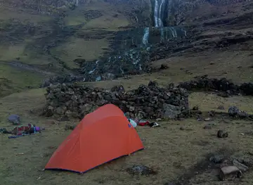
The Ausangate Trek follows a demanding circuit through the remote highlands of the Cusco region, circling Ausangate, the highest mountain in southern Peru at approximately 6,384 metres. The route crosses broad puna grasslands, glacial passes, mineral-coloured hills and valleys scattered with turquoise lakes, while herds of alpacas and llamas graze beside traditional settlements. Unlike the Inca Trail, this is primarily a wilderness and pastoral journey, with long stretches where natural scenery and local livelihoods define the experience more than built attractions.Read more about Ausangate Trek
Communities and Cultural Landscape
High Passes and Rainbow Mountain
When is the best time to visit Ausangate Trek?
Best: July–September · 14°C| Month | High (°C) | Rainfall (mm) |
|---|---|---|
| January | 15 | 35 |
| February | 15 | 30 |
| March | 15 | 25 |
| April | 15 | 20 |
| May | 15 | 15 |
| June | 14 | 10 |
| July (best) | 14 | 5 |
| August (best) | 14 | 5 |
| September (best) | 14 | 10 |
| October | 15 | 15 |
| November | 15 | 20 |
| December | 15 | 25 |
Getting to and around Ausangate Trek
How to get there
Transportation
Best attractions in Ausangate Trek
The central attraction is the high-altitude circuit around Nevado Ausangate, where the trail links broad puna, glacial valleys, mineral-coloured slopes and a series of lakes including Puca Cocha and other waters near the mountain's eastern and western flanks. The route's passes provide changing views of Ausangate and neighbouring peaks, while alpaca herds, llamas and remote Quechua settlements reveal the landscape's continuing pastoral life. Upis is associated with hot springs and a popular approach to the circuit, although facilities and conditions should be confirmed locally. Some itineraries continue towards Vinicunca, or Rainbow Mountain, and the Red Valley, whose striped slopes draw large numbers of day visitors; these lie within the wider highland trekking area but are not synonymous with the entire Ausangate circuit. Around the approaches, Ocongate, Tinki and Pitumarca function as practical gateways rather than attractions within the wilderness itself.
-
Tourist attraction
Vinicunca Rainbow Mountain
Discover the breathtaking beauty of Vinicunca Rainbow Mountain, a vibrant natural wonder in the heart of the Peruvian Andes.
-
Tourist attraction
Cochahuasi Animal Sanctuary
Explore Cochahuasi Animal Sanctuary - a wildlife refuge in Peru dedicated to rehabilitating rescued animals and promoting conservation education.
-
Tourist attraction
Sapantiana Aqueduct
Explore the historic Sapantiana Aqueduct in Cusco, a stunning colonial masterpiece offering breathtaking views and a glimpse into the region's rich history.
-
Hiking area
Rainbow Mountain Cusipata Trail Parking
Experience the vibrant beauty of Rainbow Mountain on the Cusipata Trail, a must-visit hiking destination in the captivating Peruvian Andes.


Best landmarks in Ausangate Trek
Nevado Ausangate is the defining natural landmark, a heavily glaciated Andean massif revered locally as an apu and rising above the circuit's lakes and puna. The surrounding passes and mineral-coloured hills are landmarks in their own right, demonstrating the sharp contrasts between dark rock, snow, red slopes and intensely coloured water. Upis marks a recognised approach area and is associated with thermal springs, while the lakes around Puca Cocha and the mountain's eastern side form memorable stages of the circuit. Vinicunca, or Rainbow Mountain, is the best-known nearby geological landmark, created by exposed layers of differently coloured sediment and minerals; it is commonly visited as a separate excursion or route extension. The remote settlements, adobe structures and pastoral enclosures encountered along the trail are cultural landmarks of a living Quechua highland landscape rather than museum exhibits.
-
 Historical place
Historic Sanctuary of Machu Picchu
Explore the Historic Sanctuary of Machu Picchu, an iconic archaeological site that reveals the grandeur of Inca civilization high in the Andes mountains.
-
Historical place
Saqsaywaman
Discover the architectural marvel of Saqsaywaman, an Inca fortress with breathtaking views and rich history in Cusco, Peru.
-
Ravine
Sacred Valley
Explore the Sacred Valley: A stunning blend of natural beauty, rich culture, and Inca history in the heart of Peru.
-
Mountain peak
Nevado Auzangate
Explore the majestic Nevado Auzangate, a breathtaking mountain peak in the Peruvian Andes, perfect for adventurous trekkers and nature lovers.


Explore Ausangate Trek on the map
Plan your trip on one map. See where the top attractions, landmarks, restaurants and hotels are, and book hotels and experiences in a few clicks.
Best hotels in Ausangate Trek
Best restaurants in Ausangate Trek
Dining on the Ausangate Trek is primarily part of the trekking arrangement rather than a restaurant-based experience. Organised expeditions commonly provide camp meals prepared by cooks, with menus adapted to long days at altitude and ingredients purchased in Cusco or gateway settlements. In villages and towns such as Tinki, Ocongate, Pitumarca and larger stops along the approach roads, visitors may find simple local eateries serving Andean staples such as soups, potatoes, rice, grains and meat, though choice and opening times can be limited. Cusco is the best place to explore the wider cuisine of the region, including corn, native potatoes, quinoa and alpaca, while trout is associated with many highland waterways and restaurants in the broader Cusco countryside. Trekkers should carry snacks and confirm whether meals, drinking water and dietary requirements are included in their expedition.
-
Peruvian
Pachapapa
Discover the rich flavors of Peru at Pachapapa, a charming restaurant in Cusco serving authentic dishes made from fresh local ingredients.
-
Restaurant
Organika Restaurant
Experience authentic Peruvian flavors at Organika Restaurant in Cusco - where local ingredients meet innovative cuisine.
-
Peruvian
Mapacho Craft Beer Restaurant
Experience authentic Peruvian cuisine paired with exquisite craft beers at Mapacho Craft Beer Restaurant in Cusco.
-
Restaurant
Republica Del Pisco - Cusco
Discover the essence of Peruvian cuisine at Republica Del Pisco - a vibrant restaurant-bar in the heart of Cusco offering exquisite dishes and cocktails.


Best bars in Ausangate Trek
The Ausangate Trek has no developed nightlife in the mountains, and evenings are generally spent at campsites after sunset, with trekkers, guides and local support staff preparing for the next early start. Small towns on the approach, including Tinki and Ocongate, have modest local drinking establishments rather than a visitor-oriented bar scene, while Pitumarca offers a similarly quiet rural atmosphere. More varied evening entertainment is found in Cusco, outside the destination, where restaurants, traditional music venues and bars serve the city's large resident and visitor population. Alcohol is best avoided before or during high-altitude trekking because dehydration, poor sleep and reduced recovery can compound the effects of strenuous exertion. Seasonal community festivities may include music and dancing, but dates and access vary and should not be assumed.
-
Restaurant
GRUPO ADVENTURE 7 LAGUNAS AUSANGATE Y BAÑOS TERMALES PACCHANTA
Experience the tranquility of thermal baths and the breathtaking beauty of lagoons in the heart of the Andes at GRUPO ADVENTURE 7 LAGUNAS AUSANGATE Y BAÑOS TERMALES PACCHANTA.

Best nightclubs in Ausangate Trek
The Ausangate Trek has no developed nightlife in the mountains, and evenings are generally spent at campsites after sunset, with trekkers, guides and local support staff preparing for the next early start. Small towns on the approach, including Tinki and Ocongate, have modest local drinking establishments rather than a visitor-oriented bar scene, while Pitumarca offers a similarly quiet rural atmosphere. More varied evening entertainment is found in Cusco, outside the destination, where restaurants, traditional music venues and bars serve the city's large resident and visitor population. Alcohol is best avoided before or during high-altitude trekking because dehydration, poor sleep and reduced recovery can compound the effects of strenuous exertion. Seasonal community festivities may include music and dancing, but dates and access vary and should not be assumed.
-
Disco club
Inka Team
Experience the vibrant nightlife of Cusco at Inka Team, where locals and travelers unite to dance the night away in a colorful disco atmosphere.
-
Disco club
El Muki
Experience the vibrant nightlife at El Muki, Cusco's premier disco club, where music and culture come alive in a dazzling atmosphere.
-
Bar
Chango Club Cusco
Experience the pulsating energy of Chango Club in the heart of Cusco, where nightlife comes alive with vibrant music, local cocktails, and unforgettable memories.
-
Club
Rock House Cafe
Experience Cusco's vibrant nightlife at Rock House Cafe, a lively gastropub with delicious cuisine and live music in the heart of the city.


Best shops in Ausangate Trek
Shopping opportunities on the Ausangate route are extremely limited, with no continuous retail area in the high mountains. Small village shops and market stalls in gateway settlements such as Tinki, Ocongate and Pitumarca may provide basic provisions, while Cusco is the principal place for trekking equipment, food supplies and a broader selection of Andean textiles and crafts. Visitors may encounter locally produced knitted goods, woven items or alpaca-related products in communities and markets, but availability and authenticity vary, so purchases should be made respectfully and without treating local households as informal shops. Buying directly from established community sellers can support local income, while practical supplies should be obtained before leaving Cusco or the nearest substantial town. There are no dependable shopping facilities at remote camps, passes or lakes.
-
Plaza
Plaza Mayor de Cusco
Explore the vibrant Plaza Mayor de Cusco, a historic plaza adorned with captivating architecture, local culture, and delicious Peruvian cuisine.
-
Market
Mercado Central de San Pedro
Discover the heart of Cusco at Mercado Central de San Pedro, a vibrant market filled with local flavors, crafts, and culture.
-
Hotel
Palacio del Inka, a Luxury Collection Hotel, Cusco
Discover the luxury and history of Palacio del Inka, a perfect blend of culture and comfort in the heart of Cusco.
-
Handicraft
Handicraft Center Cusco
Explore the Handicraft Center in Cusco for a vibrant selection of authentic Peruvian souvenirs and artisanal treasures.


Get your free copy of our complete guide to Ausangate Trek, delivered straight to you.
Everything on this page, from attractions and restaurants to essentials and local phrases, in one PDF you can read offline, print or share.
Already have an account? Sign in
Your Ausangate Trek guide is ready.
We'll send it to · Not you? Sign out

Getting your guide ready…
We are putting together a fresh copy of the Ausangate Trek guide. This can take up to a minute.
This can take a few moments. If your browser asks, choose Allow so the download can start. You'll find the guide in your Downloads folder.
Nothing happened? Download it again
Sorry, the guide is taking longer than usual. Please try again in a minute, or get it by email instead.
Ausangate Trek essentials
Currency and Payment
Safety
Emergency Situations
Do's and Don'ts
Local Tips
From Eve
Local phrases worth knowing
You don't need to get them perfect. A few words go a long way, and locals appreciate the effort.
Basics
| English | Local | Say it |
|---|---|---|
| Hello | Qanmi | [kahn-mee] |
| Goodbye | Allinllataq | [ahl-leen-yah-tahk] |
| Yes | Arí | [ah-ree] |
| No | Mana | [mah-nah] |
| Please/You're welcome | Asiriy | [ah-see-ree] |
| Thank you | Sulpayki | [sool-pie-kee] |
| Excuse me/Sorry | Pipas | [pee-pahs] |
| How are you? | Ima kashanki? | [ee-mah kah-shahn-kee] |
| Fine. And you? | Allin. Qanmi? | [ahl-leen. kahn-mee] |
| Do you speak English? | Inglispayki rimaykuyki? | [ing-lees-pie-kee ree-mahy-koo-ykee] |
| I don't understand | Mana yupaychani | [mah-nah yoo-pie-chah-nee] |
Eating & Drinking
| English | Local | Say it |
|---|---|---|
| I'd like to see the menu, please | Menukuna qawaykuni kay? | [meh-noo-koo-nah kah-wahy-koo-nee kie] |
| I don't eat meat | Karnirqa mana ñuqaychani | [kahr-nee-rr-kah mah-nah nyoo-kahy-chah-nee] |
| Cheers! | Ari qillqay | [ah-ree keel-yahy] |
| I would like to pay, please | Taripaykuni kay? | [tah-ree-pahy-koo-nee kie] |
Emergencies
| English | Local | Say it |
|---|---|---|
| Help! | Jatun! | [hah-toon] |
| Go away! | Llasa! | [llah-sah] |
| Call the Police! | Pulispiy llamay! | [poo-lees-pee-ee yah-mahy] |
| Call a doctor! | Yachachiq llamay! | [yah-chah-cheek yah-mahy] |
| I'm lost | Ayniymi | [ah-ynee-mee-mee] |
| I'm ill | Purikuy | [poo-ree-koo-ee] |
Shopping
| English | Local | Say it |
|---|---|---|
| I'd like to buy... | Suniyniyki... | [soo-nee-ee-nee-kee] |
| I'm just looking | Qhawaykuy | [kah-wahy-koo-ee] |
| How much is it? | Ima chay? | [ee-mah chahy] |
| That's too expensive | Taqanakuy | [tah-kahn-ah-koo-ee] |
| Can you lower the price? | Chaymanta uchuyta? | [chahy-mahn-tah oo-chwee-tah] |
Time & Numbers
| English | Local | Say it |
|---|---|---|
| What time is it? | Ima qamuy? | [ee-mah kah-moo-ee] |
| It's one o'clock | Tawa kawanku | [tah-wah kah-wahn-koo] |
| Half past (10) | Iskay punchaw | [ees-kahy poon-chahw] |
| Morning | Pacha | [pah-chah] |
| Afternoon | Inti chaskiq | [een-tee chahs-kee] |
| Evening | Tuta | [too-tah] |
| Yesterday | Illapa | [eel-lah-pah] |
| Today | Kay | [kie] |
| Tomorrow | K'anchay | [kah-nchahy] |
| 1 | Huk | [hook] |
| 2 | Iskay | [ees-kahy] |
| 3 | Kimsa | [keem-sah] |
| 4 | Tawa | [tah-wah] |
| 5 | Pichqa | [peech-kah] |
| 6 | Soqta | [sohk-tah] |
| 7 | Qanchis | [kahn-chees] |
| 8 | Pusaq | [poo-sahk] |
| 9 | Iskay | [ees-kahy] |
| 10 | Chunka | [choon-kah] |
Transport & Directions
| English | Local | Say it |
|---|---|---|
| Where's a/the...? | Qam... | [kahm...] |
| What's the address? | Ima sutiy? | [ee-mah soo-tee] |
| Can you show me (on the map)? | Kay pachaqchini? | [kie pah-chahk-chee-nee] |
| When's the next (bus)? | Ima huk... | [ee-mah hook...] |
| A ticket (to ....) | Chiqan... | [chee-kahn...] |
History of Ausangate Trek
An Andean Landscape of Glacial Formation
Ausangate's terrain was shaped over geological timescales by uplift in the Andes, glaciation and the erosion of high mountain rock. Glaciers and seasonal meltwater continue to influence the circuit's lakes, streams and wetlands, while freeze-thaw processes contribute to the stark forms of the surrounding peaks and passes. The coloured slopes seen in parts of the wider area arise from differing mineral compositions exposed by erosion, although the appearance of individual hills varies with light, weather and viewpoint. These geological processes provide the physical setting for a landscape that has supported human communities for centuries.
Pastoral Communities and Sacred Mountains
Long before modern trekking routes developed, highland communities used the puna for alpaca and llama herding, movement between seasonal pastures and limited cultivation in more sheltered areas. Quechua remains widely spoken in the region, and Andean religious traditions continue to regard major peaks as apus, powerful sacred presences connected with protection, water and fertility. Ausangate therefore belongs to a living cultural landscape rather than an empty wilderness. Local households, communal land practices and pastoral work remain visible along paths that visitors now follow as trekking routes.
Inca and Colonial-Era Connections
The Ausangate region formed part of the wider southern Peruvian highlands integrated into the Inca world, although the circuit is not defined by the monumental stone architecture associated with routes closer to Cusco. Highland exchange, herding networks and links between communities connected remote valleys with larger centres. During the colonial period, Spanish rule, Christian institutions and changing systems of landholding affected Andean society, while local communities retained language, agricultural knowledge and mountain traditions. The surviving cultural character of villages around the massif reflects this layered history rather than a single historical period.
Modern Trekking and Conservation Challenges
Ausangate became better known to international trekkers as interest grew in remote high-altitude routes beyond the Inca Trail. Tourism has created income for guides, muleteers, cooks and community members, but the circuit remains comparatively lightly serviced and environmentally sensitive. More recent attention has also focused on the wider Cusco highlands' pressures, including waste, road expansion, visitor concentration at Rainbow Mountain and the effects of climate change on glaciers and water systems. Responsible trekking depends on local cooperation, respect for communal land and careful management of fragile puna habitats.
Ausangate Trek in Photos
Browse through our photo collection highlighting the charm and character of the destination.
Cities in Ausangate Trek
The towns and cities of Ausangate Trek, and the easiest places to base yourself.
-

-

-
-
-

-


Swipe for more cities
Neighbouring destination travel guides
The closest destinations to Ausangate Trek, if you have time for more than one.
-

-

-
-

-


Swipe for more destinations
Explore more

Explore more of Madre de Dios
Explore Madre de Dios, Peru: A biodiverse haven in the heart of the Amazon offering breathtaking wildlife, lush rainforests, and rich indigenous culture.
Explore Madre de Dios
Explore more of Peru
Discover the wonders of Peru: ancient ruins, stunning landscapes, and a vibrant culture that will captivate your heart and soul.
Explore Peru