

Slave Island (Colombo) Travel Guide - Free
Explore Slave Island in Colombo with Evendo's free guide. Find the best shops, historic streets, restaurants, and gems on web or mobile.


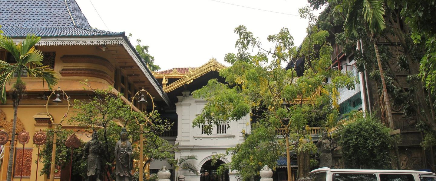


Slave Island in Colombo blends Beira Lake views, Sri Lankan Malay heritage, Hindu worship, local eateries and central-city walks near Fort and Galle Face.
A Former Island in Central Colombo
Slave Island, commonly known locally as Kompannavidiya, occupies a compact and changing area just south of Colombo Fort, bordered by sections of Beira Lake and the broad routes leading towards Galle Face. Its English name recalls the colonial period, when the area was associated with the confinement of enslaved people; the Sinhala-derived name Kompannavidiya means “Company Village”, reflecting the presence of the Dutch East India Company. Today, roads, railway infrastructure and reclamation have made the former island part of the continuous city, but the water still gives parts of the neighbourhood a distinctive setting.Read more about Slave Island
Religious and Cultural Layers
Street Life and Urban Change
Best attractions in Slave Island
Slave Island’s attractions are concentrated in its layered streetscape rather than in a large museum or formal visitor precinct. The Sri Siva Subramaniam Swamy Kovil on Galle Road is the neighbourhood’s most conspicuous cultural sight, with colourful Hindu iconography and an active devotional setting that should be approached respectfully. Beira Lake provides a changing visual backdrop, particularly where the water, roads and railway infrastructure meet, while the surrounding streets reveal older low-rise buildings, local businesses and traces of Colombo’s multi-community history. Walkers can observe the contrast between established residential and commercial areas and the high-rise construction reshaping the central waterfront. The district is also well placed for continuing towards Colombo Fort, Pettah or Galle Face, but these are nearby areas rather than attractions within Slave Island itself. Its appeal lies in reading the city’s history through movement, architecture and daily life.
-
Catholic church
Infant Jesus Shrine and Holy Rosary Church - Colombo | ජේසු බිලිදුන්ගේ රන් දෙවොල සහ ජපමාල දේවමාතා දේවස්ථානය - කොලඹ
Discover the tranquility and beauty of the Infant Jesus Shrine and Holy Rosary Church, a spiritual haven in the heart of Colombo, Sri Lanka.
3 min walk · 0.3 km from neighbourhood centre
-
Tourist attraction
Beira Lake Park
Discover tranquility at Beira Lake Park, an urban retreat in Colombo, where serene waters meet the vibrant pulse of city life.
5 min walk · 0.4 km from neighbourhood centre
-
Mosque
Java land Jumna Mosque Slave Island
Explore the Jumna Mosque in Slave Island, Colombo - a serene sanctuary showcasing stunning Islamic architecture and vibrant local culture.
3 min walk · 0.2 km from neighbourhood centre
-
Historical landmark
Slave Island Srilanka
Explore the rich cultural heritage of Slave Island, Sri Lanka, a historical landmark reflecting the island's colonial past and vibrant local life.
2 min walk · 0.2 km from neighbourhood centre


Best landmarks in Slave Island
The Sri Siva Subramaniam Swamy Kovil is Slave Island’s principal landmark, standing on Galle Road as a visible expression of the Tamil Hindu presence within central Colombo. Its colourful temple architecture and continuing religious use give the surrounding streets a cultural focus, though visitors should remember that it is a place of worship rather than simply a photographic object. Beira Lake is another defining feature, preserving the water-based geography that once helped make the area an island or lake-separated settlement. The railway corridor and Kompannavidiya station represent the later integration of Slave Island into Colombo’s transport network, while the dense road junctions and changing skyline record more recent urban development. The neighbourhood’s significance lies in the relationship between these elements: colonial water defences, community institutions, transport infrastructure and redevelopment occupy the same compact urban landscape.
-
Hindu temple
Sivasubramania Swami Kovil
Explore the vibrant Sivasubramania Swami Kovil in Colombo, a cultural gem showcasing stunning architecture and rich Hindu traditions.
3 min walk · 0.2 km from neighbourhood centre
-
Historical landmark
Slave Island Srilanka
Discover the rich history and vibrant culture of Slave Island, Colombo, a must-visit historical landmark with captivating architecture and local charm.
2 min walk · 0.2 km from neighbourhood centre


Explore Slave Island on the map
A handpicked selection of must-see spots in Slave Island, mapped for you.
Best hotels in Slave Island
Best restaurants in Slave Island
Eating in Slave Island is primarily an everyday local experience rather than a concentrated restaurant quarter. Small cafés, rice-and-curry counters, snack shops and modest eateries serve office workers, residents and travellers moving between Fort, Colombo 2 and the southern suburbs. The neighbourhood’s Malay associations form part of its culinary context, while Sri Lankan Muslim, Tamil and broader island cooking traditions appear in the wider mix of rice dishes, short eats, roti, string hoppers and spicy accompaniments. Roadside stalls and informal shops may be more characteristic than destination dining rooms, so a little patience and visual judgement are useful when choosing where to eat. Larger selections of restaurants and international dining are available in nearby Fort, Colombo 2 and along Galle Road, but should not be described as Slave Island venues. Visitors should also expect changing premises as redevelopment affects established streets and businesses.
-
Halal
Fazly's Halal Refreshment
Discover the flavors of halal fast food at Fazly's Halal Refreshment in Colombo – where taste meets tradition!
2 min walk · 0.2 km from neighbourhood centre
-
Restaurant
A-One Cafe
Discover the flavors of Sri Lanka at A-One Cafe in Colombo - where local cuisine meets warm hospitality.
3 min walk · 0.2 km from neighbourhood centre
-
Restaurant
SAMAL RESTAURANT PVT LTD
Experience the vibrant flavors of Western cuisine at Samal Restaurant Pvt Ltd in Colombo, where great food meets exceptional service.
1 min walk · 0.1 km from neighbourhood centre
-
Restaurant
The Cue
Discover authentic Sri Lankan cuisine at The Cue in Colombo - a delightful dining experience filled with local flavors and warm hospitality.
2 min walk · 0.2 km from neighbourhood centre


Best bars in Slave Island
Slave Island itself has a limited and uneven nightlife scene, with evening activity centred more on local restaurants, cafés, shops and residents’ daily routines than on a dense strip of bars or clubs. The main roads remain active, but quieter residential lanes are not entertainment zones and should be treated with consideration after dark. Nearby Colombo 2, Fort and the Galle Face waterfront provide a broader choice of hotel bars, restaurants and evening venues, although they are neighbouring districts rather than part of Slave Island. The area’s most distinctive evening atmosphere comes from the changing lights around Beira Lake, traffic moving along Galle Road and the continued presence of religious and community life. Venue availability and access can change as central Colombo’s redevelopment progresses, so current local information is more reliable than assuming older nightlife listings remain accurate.
-
Bar
The Cabinet Bar & Lounge
Discover the vibrant nightlife of Colombo at The Cabinet Bar & Lounge, where creative cocktails and a cozy atmosphere await.
4 min walk · 0.3 km from neighbourhood centre
-
Restaurant
SAMAL RESTAURANT PVT LTD
Experience the vibrant taste of Colombo at Samal Restaurant Pvt Ltd, where Western cuisine meets local hospitality in a lively bar and grill setting.
1 min walk · 0.1 km from neighbourhood centre


Best shops in Slave Island
Shopping in Slave Island is mainly local and practical, with small groceries, convenience shops, food sellers, clothing outlets, repair businesses and other independent enterprises serving nearby residents and workers. The streets around Galle Road and the internal road network are more useful for observing everyday commerce than for browsing a defined tourist retail district. Visitors may find Sri Lankan snacks, household goods and inexpensive clothing, but stock and business locations can change as redevelopment proceeds. Pettah, immediately north-west across the central Colombo transport area, is the city’s larger market district, while Fort and Colombo 2 offer more formal retail and contemporary shopping; all should be treated as nearby rather than within Slave Island. The neighbourhood’s commercial character is consequently intimate and functional, shaped by community needs and passing commuters rather than by souvenir shops or a curated independent-boutique scene.
-
Hardware store
M. M. Noorbhoy & Co (Pvt) Ltd
Explore M. M. Noorbhoy & Co in Colombo for top-notch hardware and home improvement solutions, catering to every DIY enthusiast's needs.
1 min walk · 0.1 km from neighbourhood centre
-
Herbal medicine store
VISHWA SPICE AND AYURVEDA HERBAL SHOP
Unveil the secrets of natural healing and authentic spices at Vishwa Spice and Ayurveda Herbal Shop in Colombo, Sri Lanka.
1 min walk · 0.1 km from neighbourhood centre
-
Bakery
Caravan Fresh - The Cake & Pastry Shop
Discover the sweet side of Colombo at Caravan Fresh - a bakery paradise for cake and coffee lovers.
1 min walk · 0.1 km from neighbourhood centre
-
Fishing store
Hobby Fishing tackles
Explore a vast selection of premium fishing gear at Hobby Fishing Tackles, your ultimate destination for fishing in Colombo, Sri Lanka.
1 min walk · 0.1 km from neighbourhood centre


Slave Island essentials
Getting There
Getting Around
Safety
Emergency Situations
Do's and Don'ts
Local Tips

From Eve
Local phrases worth knowing
You don't need to get them perfect. A few words go a long way, and locals appreciate the effort.
Basics
| English | Local | Say it |
|---|---|---|
| Hello | හායි | [haayi] |
| Goodbye | සුරං | [suran] |
| Yes | ඔව් | [ow] |
| No | නෑ | [nae] |
| Please/You're welcome | කරන්න | [karanna] |
| Thank you | ආයුබෝවන් | [ayubowan] |
| Excuse me/Sorry | කාටද? | [kaatda] |
| How are you? | ඔය කොහද? | [oyaa kohda] |
| Fine. And you? | තෝරා. ඔය? | [thora. oya?] |
| Do you speak English? | ඔය ඉංග්රීසි කතා කරයිද? | [oya ingreesi katha karayida?] |
| I don't understand | මම අතකොත් දැන්නෙයි | [mama athakoth danneyei] |
Eating & Drinking
| English | Local | Say it |
|---|---|---|
| I'd like to see the menu, please | මෙන්රඩ් එක බලන්න | [menuradha eka balanna] |
| I don't eat meat | මම වත්මැල කරන්නෙයි | [mama wathmala karannei] |
| Cheers! | සුභ උන්නේවා | [suba unneva] |
| I would like to pay, please | ගෙදරට කියන්නෙයි | [gedarata kiyannei] |
Emergencies
| English | Local | Say it |
|---|---|---|
| Help! | උක්ක ඉක්ක | [ukka ikka] |
| Go away! | යන්න | [yanna] |
| Call the Police! | පොලිස් දාන්න | [polis dannaein] |
| Call a doctor! | වෛර දාන්න | [vaira dannaein] |
| I'm lost | මම අකිල් | [mama akil] |
| I'm ill | මම අස්වල් | [mama aswal] |
Shopping
| English | Local | Say it |
|---|---|---|
| I'd like to buy... | මෙන්ඩ් කරන්නේද? | [menadha karanneda?] |
| I'm just looking | මම දැන්නෙයි | [mama dannayi] |
| How much is it? | එයට කොණ්ද? | [eyata kondha?] |
| That's too expensive | එය ඉතායි | [eya ithayi] |
| Can you lower the price? | එය කහල් කළ හැකිද? | [eya kahal kala haeidha?] |
Time & Numbers
| English | Local | Say it |
|---|---|---|
| What time is it? | වේලාව කොරේද? | [welawa koreda?] |
| It's one o'clock | එකට | [ekata] |
| Half past (10) | දහයි | [dahayi] |
| Morning | උදේවල | [udewala] |
| Afternoon | පසළ | [pasala] |
| Evening | වැනි | [wani] |
| Yesterday | ඊයේ | [iyae] |
| Today | අද | [ada] |
| Tomorrow | හෙට | [heta] |
| 1 | එක | [eka] |
| 2 | දෙක | [deka] |
| 3 | තුන | [thuna] |
| 4 | හතලි | [hathali] |
| 5 | පහ | [paha] |
| 6 | හය | [haya] |
| 7 | හත | [hatha] |
| 8 | අට | [ata] |
| 9 | නත | [nata] |
| 10 | දහය | [dahaya] |
Transport & Directions
| English | Local | Say it |
|---|---|---|
| Where's a/the...? | එස්ත් එකක් වෙලාවට? | [est ekak velavata?] |
| What's the address? | ලිපිනය කුමාටද? | [lipinaya kumadha?] |
| Can you show me (on the map)? | මාපට ලේබිකයට පෙන්නෙද? | [mapata lebikayata penneida?] |
| When's the next (bus)? | ඊළඟ කුමාටද? | [iilaga kumadha?] |
| A ticket (to ....) | ටිකට් (.... වෙනස්) | [tikat (... venas)] |
History of Slave Island
The Dutch Company Village
The area now called Slave Island developed within the colonial landscape south of Colombo’s fortifications. Its Sinhala name, Kompannavidiya, is generally understood as “Company Village”, linking it to the Dutch East India Company, which controlled Colombo during the seventeenth and eighteenth centuries. The English name Slave Island reflects later colonial usage and the area’s association with enslaved people held or employed there, although the precise historical circumstances behind the name are discussed in different accounts. Beira Lake and its channels helped separate the district from the fortified town and contributed to its strategic importance.
Water, Military Use and Settlement
Under Dutch and British rule, the waterways around Slave Island were part of Colombo’s defensive and transport geography. The neighbourhood lay beyond the main fort and became associated with military facilities, labouring communities and expanding urban settlement. The presence of the lake influenced movement and land use, while roads eventually connected the former island more firmly with the rest of the capital. Its position between the fort, harbour approaches and southern coastal road made it valuable even as the original island geography became less apparent.
Malay Community and Colombo Life
Slave Island became one of the places in Colombo associated with the city’s Malay community, whose members arrived in Ceylon through several historical routes, including military and political movements under European colonial rule. Malay families, religious institutions and social networks helped shape the neighbourhood’s identity, alongside Tamil Hindu, Muslim, Sinhalese and other communities. This layered social history is visible less through a single preserved historic quarter than through religious buildings, family businesses, food traditions and the everyday mixture of languages and customs found along its streets.
Reclamation and Modern Redevelopment
During the nineteenth and twentieth centuries, roads, railways, drainage works and urban expansion reduced the practical separation created by Beira Lake. Slave Island became an integrated central Colombo district while retaining its historic name and associations. In the twenty-first century, large-scale redevelopment around Colombo’s central waterfront has introduced new commercial and residential construction and changed familiar views, routes and property patterns. The resulting neighbourhood combines older community life and religious landmarks with construction, infrastructure and high-rise development, making it a particularly clear example of Colombo’s changing inner city.
Slave Island in Photos
Browse through our photo collection highlighting the charm and character of the destination.
Neighbourhoods near Slave Island
The closest neighbourhoods to Slave Island, if you have time for more than one stop.
-

-

-

-


Swipe for more neighbourhoods
Explore more

Explore more of Colombo
Colombo, Sri Lanka’s coastal capital, combines colonial landmarks, Buddhist temples, lively markets, modern galleries, Indian Ocean sunsets and distinctive island cuisine.
Explore Colombo