

Assateague Island Travel Guide - Free Web & App
Your ultimate guide to Assateague Island. Discover top landmarks, proposed trips, and local tips. Free on the web or via the Evendo companion app.


Assateague Island, Virginia, pairs Atlantic beaches, wild horses, dunes and Chincoteague Refuge wildlife with kayaking, birdwatching and coastal history.
Barrier Island Landscapes
Assateague Island is a long, shifting barrier island on Virginia’s Eastern Shore, separated from the mainland by shallow bays and reached through the town of Chincoteague. The Virginia portion is shared between the Assateague Island National Seashore and Chincoteague National Wildlife Refuge, creating a landscape of broad Atlantic beaches, rolling dunes, salt marshes, maritime forest and tidal inlets. Unlike a conventional seaside resort, the island has very limited permanent development: its character comes from wind, surf, open horizons and the constant movement of sand and water.Read more about Assateague Island
Wildlife and Coastal Character
Chincoteague as the Gateway
When is the best time to visit Assateague Island?
Best: May, September–October · 21–27°C| Month | High (°C) | Rainfall (mm) |
|---|---|---|
| January | 8 | 81 |
| February | 9 | 80 |
| March | 14 | 90 |
| April | 18 | 86 |
| May (best) | 24 | 92 |
| June | 29 | 100 |
| July | 32 | 111 |
| August | 31 | 106 |
| September (best) | 27 | 96 |
| October (best) | 21 | 90 |
| November | 15 | 85 |
| December | 11 | 80 |
Getting to and around Assateague Island
How to get there
Transportation
Best attractions in Assateague Island
-
Hiking area
Life of the Dunes Trail
Discover the stunning Life of the Dunes Trail in Maryland, a hiker's paradise showcasing unique wildlife and breathtaking coastal views.
-
Tourist attraction
Rackliffe House
Explore the enchanting Rackliffe House, a historic gem showcasing the rich heritage and culture of Maryland's Eastern Shore near Assateague Island.
-
Tourist attraction
Pony View
Experience the serene beauty and wildlife of Pony View, a stunning tourist attraction in Chincoteague, Virginia, perfect for nature lovers and adventure seekers.
-
Off roading area
Assateague Island Hook
Discover the untouched beauty of Assateague Island Hook, where adventure meets nature on this stunning coastal paradise.


Best landmarks in Assateague Island
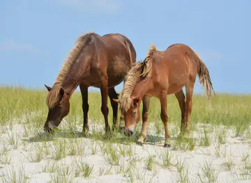
The defining natural landmark is Assateague’s Atlantic shoreline, an exposed edge of shifting sand, surf and dunes that illustrates the character of a mid-Atlantic barrier island. Behind it, the salt marshes and lagoons of Chincoteague National Wildlife Refuge form an equally important landscape, supporting migratory birds and other coastal wildlife. The wild horses are a cultural symbol as well as a living feature of the island, but they are wildlife and not a monument or attraction under human control. The causeway linking Chincoteague with the mainland marks the practical gateway to the Virginia experience, while Chincoteague’s waterfront and maritime setting provide the principal historic human landmark context. These features are valued less for monumental architecture than for the relationship between natural processes, working waters and conservation.
-
Tourist attraction
Assateague Island National Seashore
Experience the natural wonder of Assateague Island National Seashore, home to wild ponies, breathtaking beaches, and diverse wildlife in Maryland.

Explore Assateague Island on the map
Plan your trip on one map. See where the top attractions, landmarks, restaurants and hotels are, and book hotels and experiences in a few clicks.
Best hotels in Assateague Island
Get your free copy of our complete guide to Assateague Island, delivered straight to you.
Everything on this page, from attractions and restaurants to essentials and local phrases, in one PDF you can read offline, print or share.
Already have an account? Sign in
Your Assateague Island guide is ready.
We'll send it to · Not you? Sign out

Getting your guide ready…
We are putting together a fresh copy of the Assateague Island guide. This can take up to a minute.
This can take a few moments. If your browser asks, choose Allow so the download can start. You'll find the guide in your Downloads folder.
Nothing happened? Download it again
Sorry, the guide is taking longer than usual. Please try again in a minute, or get it by email instead.
Assateague Island essentials
Currency and Payment
Safety
Emergency Situations
Do's and Don'ts
Local Tips
From Eve
Local phrases worth knowing
You don't need to get them perfect. A few words go a long way, and locals appreciate the effort.
Basics
| English | Local | Say it |
|---|---|---|
| Hello | Howdy | [haw-dee] |
| Goodbye | See ya | [see-yuh] |
| Yes | Yep | [yep] |
| No | Nah | [nah] |
| Please/You're welcome | Please | [pleez] |
| Thank you | Thanks | [thanks] |
| Excuse me/Sorry | Sorry | [sor-ee] |
| How are you? | How y'all doin'? | [haw y'all doin'] |
| Fine. And you? | Good. And you? | [good. and y'all?] |
| Do you speak English? | Ya speak English? | [yah speak ing-lish?] |
| I don't understand | I ain't gettin' ya | [i aint get-tin' yah] |
Eating & Drinking
| English | Local | Say it |
|---|---|---|
| I'd like to see the menu, please | Can I see the menu, please | [can ah see the menu, please] |
| I don't eat meat | I don't eat meat | [i don't eat meat] |
| Cheers! | Cheers! | [cheers!] |
| I would like to pay, please | I'll pay now, please | [i'll pay now, please] |
Emergencies
| English | Local | Say it |
|---|---|---|
| Help! | Help! | [help!] |
| Go away! | Git! | [git!] |
| Call the Police! | Call the cops! | [call the cops!] |
| Call a doctor! | Call a doc! | [call a doc!] |
| I'm lost | I'm lost | [i'm lost] |
| I'm ill | I'm sick | [i'm sick] |
Shopping
| English | Local | Say it |
|---|---|---|
| I'd like to buy... | I wanna buy... | [i wanna buy...] |
| I'm just looking | Just lookin' | [just look-in'] |
| How much is it? | How much? | [how much?] |
| That's too expensive | Too pricey | [too pricey] |
| Can you lower the price? | Can ya lower it? | [can yah lower it?] |
Time & Numbers
| English | Local | Say it |
|---|---|---|
| What time is it? | What time is it? | [what time is it?] |
| It's one o'clock | It's one | [it's one] |
| Half past (10) | Half past ten | [half past ten] |
| Morning | Mornin' | [mornin'] |
| Afternoon | Afternoon | [afternoon] |
| Evening | Evenin' | [evenin'] |
| Yesterday | Yesterday | [yesterday] |
| Today | Today | [today] |
| Tomorrow | Tomorrow | [tomorrow] |
| 1 | One | [wun] |
| 2 | Two | [too] |
| 3 | Three | [three] |
| 4 | Four | [four] |
| 5 | Five | [five] |
| 6 | Six | [six] |
| 7 | Seven | [seven] |
| 8 | Eight | [eight] |
| 9 | Nine | [nine] |
| 10 | Ten | [ten] |
Transport & Directions
| English | Local | Say it |
|---|---|---|
| Where's a/the...? | Where's the...? | [where's the...?] |
| What's the address? | What's the address? | [what's the address?] |
| Can you show me (on the map)? | Show me (on the map) | [show me (on the map)] |
| When's the next (bus)? | When's the next (bus)? | [when's the next (bus)?] |
| A ticket (to ....) | A ticket (to ....) | [a ticket (to ....)] |
History of Assateague Island
A Shifting Barrier-Island Coast
Assateague is a geological landscape rather than a fixed piece of land. Waves, storms, currents and wind continually move its sand, opening and closing inlets and altering the shape of beaches and dunes. This instability has influenced every human use of the island, from travel and fishing to settlement and conservation. The barrier island forms part of the Atlantic coast of the Delmarva Peninsula, while the quieter bays between Assateague and the mainland have supported marshes, shellfish grounds and waterfowl habitat.
Indigenous and Maritime Connections
The island and surrounding Eastern Shore have long been connected with Indigenous communities, including peoples associated with the Assateague and wider Nanticoke region. Later European settlement developed mainly on the mainland and neighbouring islands, where fishing, shellfishing, farming and small-scale maritime trade shaped local life. Assateague’s exposed coast also formed part of a hazardous seaboard for sailing vessels, with shoals, storms and shifting channels contributing to the area’s maritime history.
Chincoteague’s Working Waterfront
Chincoteague developed as a maritime community whose economy was linked to oysters, clams, finfish, crabs and other resources of the surrounding bays and Atlantic waters. Boatbuilding, fishing and seasonal harvesting remained important expressions of local identity, while the island’s relative isolation helped preserve a distinct community culture. The horses associated with Assateague became part of regional folklore and public identity, although the animals living on the Virginia refuge are managed as wildlife rather than as a domesticated herd.
From Refuge to Protected Seashore
Chincoteague National Wildlife Refuge was established in 1943 to protect migratory birds and the coastal habitats that support them. The barrier island later became part of Assateague Island National Seashore, created in 1965 after growing recognition that the coast required protection from intensive development and storm damage. Management has since balanced public access with the needs of dunes, marshes, shorebirds, sea turtles and wild horses. Roads, beaches and refuge facilities remain subject to changing environmental conditions and conservation decisions.
Assateague Island in Photos
Browse through our photo collection highlighting the charm and character of the destination.
Neighbouring destination travel guides
The closest destinations to Assateague Island, if you have time for more than one.
-

-
-

-

-


Swipe for more destinations
Explore more

Explore more of Tidewater
Explore Tidewater Virginia for colonial history, Chesapeake seafood, Atlantic beaches, naval cities, wetlands and scenic Eastern Shore communities.
Explore Tidewater
Explore more of Virginia
Discover Virginia: A blend of historic landmarks, natural beauty, and vibrant culture perfect for history buffs, nature lovers, and culture seekers.
Explore Virginia