Background

Gamleborg Viking Fortress

Denmark's oldest fortress, where Viking kings ruled an independent island kingdom from a cliff-edge stronghold.

4

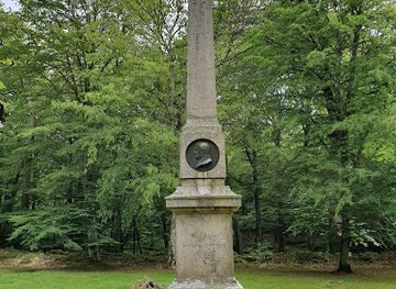
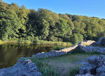
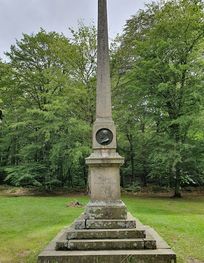
Gamleborg is Bornholm's oldest fortification, built around 750 AD as the royal seat during the Viking Age and early Middle Ages. Located on a dramatic cliff edge within Almindingen Forest, this massive fortress features impressive earth ramparts and a 6-meter-high stone wall constructed around 1100. The ruins reveal layers of medieval history, from Iron Age hideouts to Viking-era defenses, offering visitors a tangible connection to Denmark's earliest kingdoms.

A brief summary to Gamleborg

  • Ekkodalsvejen 6, Aakirkeby, 3720, DK
  • Visit website
  • Duration: 1 to 2.5 hours
  • Free
  • Environment icon Outdoor
  • Mobile reception: 4 out of 5

Local tips

  • Park at Ekkodalshuset and follow the wooden stairs leading upward to the fortress ruins. The walk is moderately steep but rewards you with views of Echo Valley and the surrounding forest landscape.
  • Visit in clear weather to fully appreciate the cliff-edge setting and the scale of the stone walls. The 6-meter ramparts are most impressive when viewed from multiple angles around the site.
  • Combine your visit with Ekkodalshuset, a nearby visitor facility offering context about the fortress and the valley's natural features, including the famous echo phenomenon.
  • Explore the walking paths throughout Almindingen Forest to understand Gamleborg's strategic positioning within the landscape and discover other historical sites on the island.
  • Bring binoculars to examine the detailed stonework of the medieval walls and observe the construction techniques used around 1100 AD during the fortress's reinforcement phase.
widget icon

Getting There

  • Car from Rønne

    Drive from Rønne toward Svaneke on the main road, then follow signs to Almindingen Forest and Ekkodalsvejen. The journey takes approximately 20–25 minutes covering roughly 15 kilometers. Park at the designated lot at Ekkodalshuset (Ekkodalsvejen 5, 3720 Aakirkeby). No entrance fee is required. The site is open daily year-round.

  • Bus from Aakirkeby

    Local buses serve Aakirkeby, the nearest town. From Aakirkeby center, it is approximately 3–4 kilometers to Gamleborg. Journey time by bus is roughly 10–15 minutes depending on route and stops. Confirm current schedules with local transport providers, as frequency varies seasonally. Walking from Aakirkeby is possible but takes 45–60 minutes on road sections without dedicated paths.

  • Walking from Ekkodalshuset

    From the parking area at Ekkodalshuset, follow the wooden stairs and marked paths upward to the fortress. The walk is moderately steep and takes 10–15 minutes to reach the main ruins. Terrain is forest floor with some uneven sections; sturdy footwear is recommended. The route is accessible year-round, though winter conditions may require extra caution on steeper sections.

  • Cycling within Almindingen Forest

    Almindingen Forest has cycling paths suitable for exploring the wider area. Gamleborg is accessible via forest routes, though the final approach to the fortress requires walking. Cycling is a practical way to visit multiple forest attractions in a single trip. Journey time from Aakirkeby by bike is approximately 20–30 minutes depending on route selection.

Gamleborg location weather suitability

  • Weather icon Clear Skies
  • Weather icon Mild Temperatures
  • Weather icon Any Weather

Unlock the Best of Gamleborg

Buy tickets

    No tickets available

Book tours with entry

    No tours available

Book tours without entry

    No tours available

Discover more about Gamleborg

A Fortress Born from Viking Ambition

Gamleborg stands as Bornholm's oldest known fortification, built around 750 AD during the Viking Age when the island functioned as an independent kingdom with its own rulers. The fortress served as the royal seat of Bornholm's kings throughout the Viking period (750–1050) and into the early Middle Ages (1050–1150). Archaeological evidence confirms its use during the reigns of Harald Bluetooth (940–986) and Canute IV (1080–1086), making it one of Denmark's earliest stone-walled structures and a testament to the island's strategic importance as a Baltic Sea trading hub. The fortress was strategically positioned to defend against Viking raids and protect the island's wealth, which included treasures of coins, jewelry, and silver bars discovered through archaeological excavations. Its location on an almost impregnable cliff at the edge of Ekkodalen (Echo Valley) provided natural defensive advantages that complemented the constructed fortifications.

Architectural Evolution and Medieval Reinforcement

The original fortifications comprised massive ramparts built from enormous boulders consolidated with earth and clay, extracted from the castle courtyard. The fortress measured 264 meters long from north to south and 110 meters wide from east to west, with defensive gates positioned to the north and south, protected by moats and outer ramparts. A small pond within the courtyard served as the castle's water supply. Around 1100 AD, significant alterations transformed Gamleborg into a more formidable stronghold. A tremendous granite wall, 275 meters long, 2 meters wide, and up to 6 meters high, was constructed along the outside of the old western defenses. The north gate was substantially widened, and a watchtower was likely erected on the northwest corner. The original southern entrance was sealed, replaced by a larger, heavily fortified gateway positioned at the southwest corner to provide enhanced protection and control.

Abandonment and Archaeological Discovery

Despite its reinforcement, Gamleborg was abandoned around 1150, with the royal court relocating approximately 700 meters northeast to Lilleborg Castle. The reasons for this transition remain unclear, though historians speculate the larger fortress may have become too expensive to maintain or difficult to defend adequately. There is no evidence of hostile destruction or military defeat; the move appears to have been a strategic administrative decision. Excavations conducted in the 1950s revealed that the fortress's origins extended beyond the Viking period, with evidence suggesting the site was used as a hideout during the Iron Age. The ruins visible today primarily reflect the medieval reconstruction work completed around 1100, preserving the fortress's most impressive architectural phase.

Setting Within Almindingen Forest

Gamleborg occupies a commanding position on a hill almost at the center of Bornholm, nestled within Almindingen Forest, one of Denmark's largest woodlands covering 3,800 hectares. The site's natural topography, particularly the 20-meter cliffs on the southern side, provided formidable defensive advantages. The forest setting creates an atmospheric backdrop for exploring the ruins, with walking paths connecting the fortress to the surrounding landscape and the nearby Echo Valley viewpoint.

Significance in Bornholm's Medieval Timeline

Gamleborg represents a crucial chapter in Bornholm's transition from independent Viking kingdom to integrated Danish territory. The fortress embodies the island's shift from pagan traditions to Christian governance, as evidenced by the construction of four iconic round churches in the 12th century following ecclesiastical rule. Its abandonment in favor of Lilleborg marked the beginning of a new defensive strategy, though Gamleborg's legacy endured as a symbol of Bornholm's autonomous past and medieval power.

Busiest months of the year

Busiest hours of the day

Popular Experiences near Gamleborg

Popular Hotels near Gamleborg

Select Currency