Inderhavnsbroen, Copenhagen Travel Guide
Free Guide: A sleek “kissing” bridge linking Nyhavn and Christianshavn, Inderhavnsbroen blends bold engineering, harbour views and Copenhagen’s daily river of cyclists.


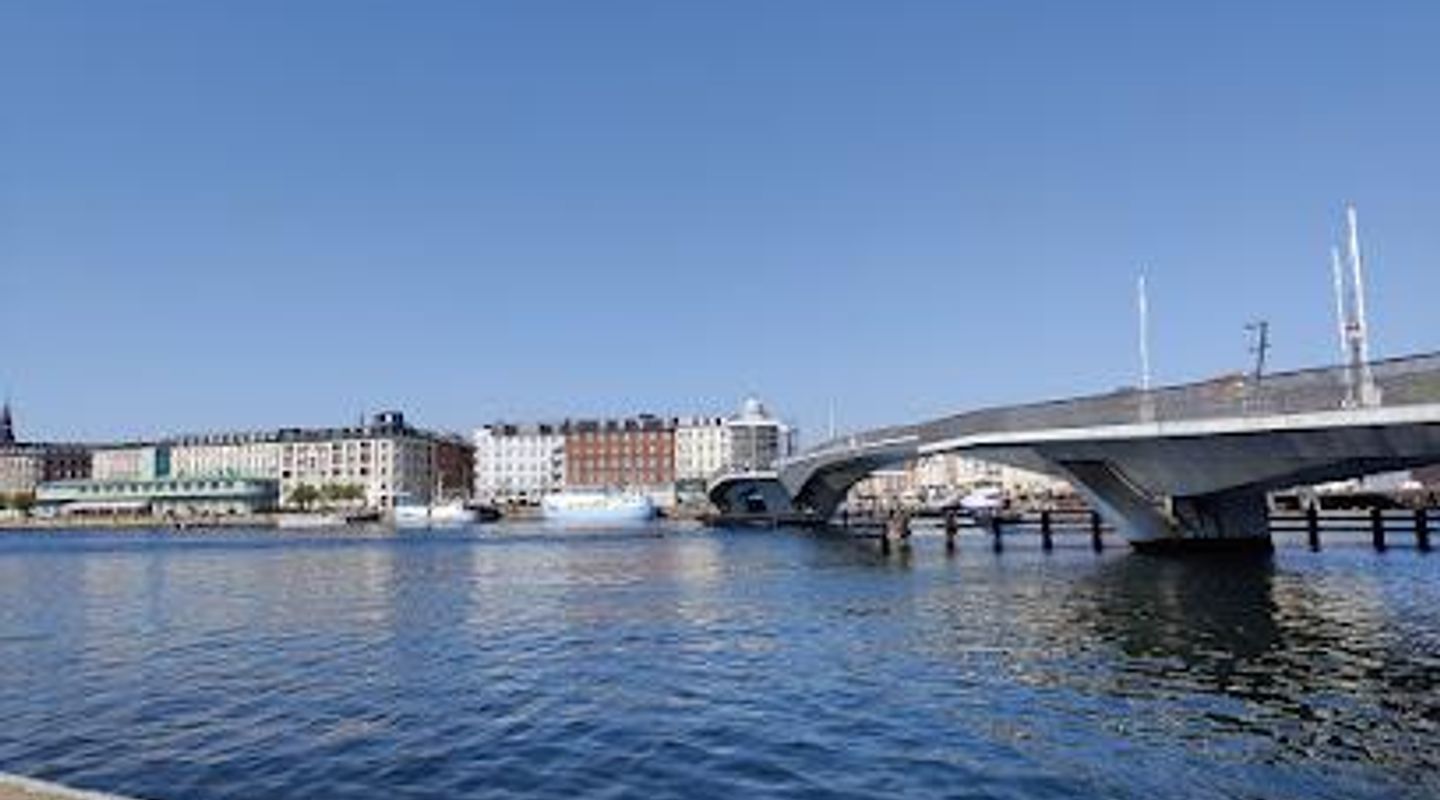
A brief summary of Inderhavnsbroen
A sleek “kissing” bridge linking Nyhavn and Christianshavn, Inderhavnsbroen blends bold engineering, harbour views and Copenhagen’s daily river of cyclists.
Stretching 180 meters across Copenhagen’s Inner Harbour, Inderhavnsbroen is a striking pedestrian and cycle bridge linking colorful Nyhavn with laid‑back Christianshavn. Nicknamed the “kissing bridge” for its sliding sections that meet in the middle, it’s both a vital everyday commuter link and a scenic waterside promenade. Come for big-sky harbour views, close-up encounters with passing boats, and a front-row look at contemporary Danish engineering in action.
On-site amenities
 Seating areas
 Trash bins
 Information boards
Opening hours
- Every day2 pm–9 am
Opening hours as listed on the venue’s Google Business Profile. Hours can change for services and special events, so check with the venue before you go.
- Address
- Inderhavnsbroen, 1401 København
Getting there
Metro from central Copenhagen
City bus and harbourfront walk
Cycling on Copenhagen’s bike network
Harbour boat tours with nearby stop
Discover more about Inderhavnsbroen
A bold link between Nyhavn and Christianshavn
Inderhavnsbroen arcs across Copenhagen’s Inner Harbour, stitching together the historic quays of Nyhavn on the city side and Christianshavn on the island of Amager. At 180 meters long and reserved for pedestrians and cyclists, it feels more like an elongated urban square than a conventional crossing, with generous decks, broad sightlines and the constant backdrop of water and sky.From the Nyhavn end, the bridge delivers an immediate shift in perspective. Turn back and you see the 17th‑century townhouses and bobbing wooden boats reduced to a colorful strip of façades; ahead, the flat lines of Christianshavn’s warehouses and modern apartments slide into view. The bridge sits low over the water, so you remain closely connected to the harbour’s movements and sounds rather than floating high above them.
The engineering behind the “kissing” motion
Inderhavnsbroen is often called the “kissing bridge” because its two central steel sections slide diagonally apart to open a navigation channel, then glide back to meet with a precise, almost theatrical touch. Instead of rising like a drawbridge or swinging aside, each half retracts into its fixed concrete approach, leaving a clear passage for tall-masted vessels heading to and from the main harbour.This unusual mechanism demanded complex engineering: curved alignment in plan, changing structural depths and carefully synchronised winches working in concert. Beneath your feet, buried chambers house the machinery that pulls the spans open and closed. When the bridge is in motion, barriers drop, bells sound and the whole deck subtly hums as steel moves against steel. For anyone interested in design and infrastructure, it is a rare chance to stand just a few metres from a working, large-scale kinetic structure.
Everyday life on Copenhagen’s cycle superhighway
Despite its sculptural qualities, Inderhavnsbroen is first and foremost a piece of everyday city fabric. Thousands of cyclists stream across daily, flowing between the offices, cafés and metro stations of the city centre and the quieter streets and canals of Christianshavn. At peak hours, you can watch a steady river of bikes in both directions, punctuated by commuters on cargo bikes, children in trailers and locals simply using the bridge as the most direct way to reach the harbourfront.Outside rush hour, the atmosphere softens. Walkers linger at the railings to watch kayakers and harbour baths, or to frame photographs of Nyhavn’s gables and the distant silhouette of the opera house. The slight crest in the middle creates a natural pause point: on clear days you can trace the harbour north towards Refshaleøen and south towards Langebro, reading Copenhagen’s changing skyline in a single slow turn.
Design details, controversies and adaptations
The bridge’s sinuous, offset geometry creates a distinctive S‑curve when seen from above, but it also introduces quirks you notice at human scale. On the Christianshavn side, a pronounced bulge requires cyclists to slow and negotiate a sharp turn, separated by a glass barrier that has become one of the bridge’s most talked‑about features. Extra markings and signage underline that this is a dead end for the cycle track, a reminder that ambitious design and everyday usability do not always align perfectly.Stairs, ramps and changes in gradient shape how different users move across the structure. Cyclists benefit from broad, continuous lanes over the water, while pedestrians can choose between gentle inclines and stepped routes that double as informal viewing platforms. Over time, small adjustments – from added warning signs to minor layout tweaks – have refined how the bridge is used, turning a headline-grabbing piece of infrastructure into a familiar, if still slightly idiosyncratic, part of the harbourfront.
Harbourfront vantage point in all seasons
Inderhavnsbroen is an outdoor space that changes character with the weather and time of day. In bright summer light, the pale deck and steelwork reflect the sun, and the harbour below shimmers with tour boats and sailing yachts. On crisp winter mornings, the low angle of the sun picks out the textures of quays, warehouses and church spires, while the wind over the water makes the short crossing feel bracing and alive.Because it is open at all hours, the bridge also offers a quietly atmospheric evening walk. Streetlights trace the curve of the deck, and reflections from nearby buildings ripple across the water. Whether you use it as a quick shortcut between neighbourhoods or treat it as a slow promenade in its own right, Inderhavnsbroen offers one of the most immediate ways to experience Copenhagen’s ongoing love affair with its harbour.
Evendo Review Centre
 Google
Guest reviews
Best time to go
Quietest: Jan, Feb & Mar · before 5am
Busy times are Evendo estimates for a typical year, to help you plan. Actual crowds vary with events, school holidays and the weather.
Explore Inderhavnsbroen on the map
A handpicked selection of must-see spots near Inderhavnsbroen, mapped for you.
Get your free copy of our complete guide to Inderhavnsbroen, delivered straight to you.
Everything on this page, from opening hours and how to get there to Eve’s tips and the best time to go, in one PDF you can read offline, print or share.
Already have an account? Sign in
Your Inderhavnsbroen guide is ready.
We'll send it to · Not you? Sign out

Getting your guide ready…
We are putting together a fresh copy of the Inderhavnsbroen guide. This can take up to a minute.
This can take a few moments. If your browser asks, choose Allow so the download can start. You'll find the guide in your Downloads folder.
Nothing happened? Download it again
Sorry, the guide is taking longer than usual. Please try again in a minute, or get it by email instead.
Unlock the best of Inderhavnsbroen
Skip-the-line tickets, guided tours with entry, and walking tours of the area, booked in a few clicks.
 Tour with entry
Hippies & Christianshavn Tip-Based Walking Tour
from $5.27 Tour with entry
Copenhagen & Christiania: Cycling Tour in French
from $52.23 Tour with entry
3 Hour Copenhagen Architecture Masterclass Bike Tour
from $63.37 Tour with entry
Copenhagen Private Full Day Tour with Lunch Option
from $356.02



Other nearby places you may find interesting
The closest places of the same kind, if this one is not quite what you had in mind.
-
-

-
-
-


Swipe for more places
More to explore near Inderhavnsbroen

 Best experiences near Inderhavnsbroen
 Best hotels near Inderhavnsbroen
 Best landmarks near Inderhavnsbroen
 Best attractions near Inderhavnsbroen
 Best shops near Inderhavnsbroen
 Best restaurants near Inderhavnsbroen
 Best bars near Inderhavnsbroen
Do you manage this location?
Take control to get all the benefits, like improved information, better appearance, and stronger visibility across AI-powered discovery.
Explore more

Explore more of Copenhagen
Discover Copenhagen: A perfect blend of history, modernity, and vibrant culture, where picturesque canals, stunning architecture, and world-class dining await you.
Explore Copenhagen
Explore more of Denmark
Discover Denmark: A perfect blend of history, modern design, and the cozy concept of hygge. Explore vibrant cities, serene landscapes, and world-class cuisine.
Explore Denmark