

Congaree National Park Travel Guide - Free Web & App
Your ultimate guide to Congaree National Park. Discover top landmarks, proposed trips, and local tips. Free on the web or via the Evendo companion app.


Congaree National Park in South Carolina protects ancient bottomland forest, floodplain trails, canoe routes and seasonal fireflies near Columbia.
Ancient Forest and River Landscape
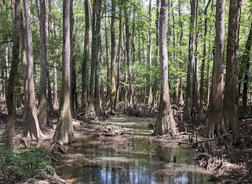
Congaree National Park lies in central South Carolina, roughly south-east of Columbia, where the Congaree River and Wateree River shape a broad, seasonally flooded floodplain. Its defining landscape is a bottomland hardwood forest, with towering trees rising above quiet creeks, muddy sloughs, tupelo wetlands and open forest floor. The park protects one of the largest remaining expanses of old-growth bottomland forest in the south-eastern United States, although water levels, storms and seasonal conditions constantly alter the appearance of its trails and waterways.Read more about Congaree National Park
Walking, Water and Wildlife
A Protected Landscape Near Columbia
When is the best time to visit Congaree National Park?
Best: April–May, October · 23–28°C| Month | High (°C) | Rainfall (mm) |
|---|---|---|
| January | 14 | 97 |
| February | 16 | 97 |
| March | 19 | 117 |
| April (best) | 23 | 107 |
| May (best) | 28 | 112 |
| June | 32 | 127 |
| July | 34 | 147 |
| August | 33 | 147 |
| September | 29 | 122 |
| October (best) | 24 | 102 |
| November | 18 | 97 |
| December | 14 | 107 |
Getting to and around Congaree National Park
How to get there
Transportation
Best attractions in Congaree National Park
The Boardwalk Loop is Congaree’s best-known introduction, leading through mature bottomland forest and wetland habitats near the Harry Hampton Visitor Center. Beyond it, the Weston Lake Loop follows changing floodplain scenery around a former channel, while the Oakridge and Kingsnake trails offer longer walks through quieter sections of the park. Cedar Creek is a central attraction for visitors exploring the landscape by canoe or kayak when water conditions and regulations permit, revealing a perspective that differs from the trails. The Congaree River forms the ecological backdrop to the entire protected area, although its waters and banks require careful attention to conditions. Wildlife watching may bring sightings of deer, wild turkeys, turtles, wading birds and other forest species, but the park’s appeal lies in the habitat as much as in individual encounters. Seasonal synchronous firefly viewing is among the park’s most distinctive experiences, subject to natural timing and current access arrangements.
-
Visitor center
Harry Hampton Visitor Center
Explore the wonders of Congaree National Park at the Harry Hampton Visitor Center, your gateway to adventure and natural history in South Carolina.
-
Campground
Longleaf Campground
Discover serenity and adventure at Longleaf Campground in Hopkins, SC, your gateway to nature and outdoor activities amidst stunning landscapes.
-
Hiking area
Kingsnake Trailhead
Discover nature's tranquility at Kingsnake Trailhead in Congaree National Park, a premier hiking destination in South Carolina.
-
Hiking area
Bates Ferry Trailhead
Discover the serene Bates Ferry Trailhead along the scenic Congaree River, a perfect escape for hikers and nature lovers in South Carolina.


Best landmarks in Congaree National Park
Congaree’s principal landmarks are natural rather than architectural. Its old-growth bottomland hardwood forest, shaped by the Congaree River floodplain, is the defining feature, with exceptionally tall trees standing over cypress-tupelo wetlands, sloughs and periodically inundated ground. The elevated Boardwalk Loop has become an emblem of the park because it allows visitors to enter this wet forest while limiting trampling of sensitive terrain. Cedar Creek and the Congaree River are important water landmarks, revealing the channels and seasonal flooding that sustain the ecosystem. The Harry Hampton Visitor Center is a significant human landmark in the park’s conservation story, recalling the campaign that helped protect the forest from large-scale logging. Outside the park, the broad river landscape and rural roads around Hopkins provide context rather than separate park monuments, helping visitors understand Congaree as part of a larger watershed rather than an isolated woodland.
-
Visitor center
Harry Hampton Visitor Center
Explore Congaree National Park’s Harry Hampton Visitor Center, your gateway to breathtaking landscapes and rich biodiversity in South Carolina.
-
Park
Friends of Congaree Swamp
Explore the enchanting landscapes and diverse wildlife of Friends of Congaree Swamp, a must-visit park for nature lovers in South Carolina.

Explore Congaree National Park on the map
Plan your trip on one map. See where the top attractions, landmarks, restaurants and hotels are, and book hotels and experiences in a few clicks.
Best hotels in Congaree National Park
Best restaurants in Congaree National Park
Congaree National Park has no conventional restaurant district, café-lined visitor centre or extensive food service within its boundaries, so most visitors eat before arriving or bring provisions for the day. Columbia, the nearest major city, provides the broadest choice of restaurants, cafés, supermarkets and takeaway food, while Hopkins and other nearby communities offer more limited local services. South Carolina’s wider culinary identity includes barbecue, coastal and Lowcountry influences, seasonal produce and Southern home-style cooking, though individual offerings vary by establishment. A picnic is often the most practical option for a full day among the trails, provided food is stored responsibly and all waste is removed or placed in designated bins. Visitors planning a canoe outing or a longer walk should carry sufficient water and food rather than expecting refreshments along the waterways or forest paths.
-
Barbecue
Big T Bar-B-Q
Experience authentic Southern barbecue at Big T Bar-B-Q in Gadsden, SC - where smoky flavors meet warm hospitality.
-
Restaurant
J D's Place
Experience the heartwarming flavors of Southern cuisine at J D's Place near Congaree National Park – where comfort meets culinary delight.
-
Restaurant
Congaree Grill
Discover Congaree Grill: A Culinary Haven in Eastover Offering Authentic Southern Cuisine with Warm Hospitality.


Best bars in Congaree National Park
Evening entertainment is limited inside Congaree National Park, where darkness, quiet woodland and wildlife habitat define the atmosphere after the day’s visitors have departed. There are no nightclubs or established nightlife districts in the park itself. Columbia, outside the destination, is the nearest place for a wider selection of bars, breweries, live music and late-evening dining, while smaller communities near the park tend towards quieter local hospitality rather than a concentrated entertainment scene. Some visitors choose an early dinner in Columbia or Hopkins and return to accommodation after walking, while seasonal firefly programmes and ranger-led activities may provide distinctive nature-based evening experiences when organised. Visitors should check current arrangements rather than assuming that evening events, food service or extended access are available every night.
-
Barbecue
Big T Bar-B-Q
Experience the best Southern barbecue at Big T Bar-B-Q in Gadsden, SC, where flavorful smoked meats and warm hospitality await every visitor.
-
Restaurant
J D's Place
Experience the best of Southern comfort food in Gadsden, SC at J D's Place, where flavor and hospitality meet.
-
Seafood
A Taste Of Birds Love
Savor the freshness of seafood at A Taste Of Birds Love in Eastover, SC, where every bite showcases local flavors and culinary craftsmanship.
-
Campground
Longleaf Campground
Experience the beauty of nature at Longleaf Campground, a peaceful haven in South Carolina for camping and outdoor adventures.


Best shops in Congaree National Park
Shopping within Congaree National Park is limited to the visitor information and educational context associated with the park, rather than a conventional retail scene. Visitors should obtain groceries, fuel, outdoor supplies and any specialist equipment in Columbia or another nearby settlement before entering the rural park area. Columbia offers the widest choice of shops, independent businesses and regional food producers, while Hopkins and smaller communities provide more modest local services. Souvenirs connected with the park may be available through official National Park Service channels, subject to current arrangements, and regional craft or food products can be found in the wider South Carolina capital area. The most useful purchases for a Congaree visit are practical ones: water, insect repellent, weather-appropriate clothing, navigation supplies and food for a day on the trails or waterways.
-
National park
Congaree National Park
Discover the natural wonder of Congaree National Park, where ancient trees meet diverse wildlife in South Carolina's breathtaking wilderness.
-
Visitor center
Harry Hampton Visitor Center
Discover the beauty and biodiversity of Congaree National Park at the Harry Hampton Visitor Center—your gateway to adventure and education in nature.


Get your free copy of our complete guide to Congaree National Park, delivered straight to you.
Everything on this page, from attractions and restaurants to essentials and local phrases, in one PDF you can read offline, print or share.
Already have an account? Sign in
Your Congaree National Park guide is ready.
We'll send it to · Not you? Sign out

Getting your guide ready…
We are putting together a fresh copy of the Congaree National Park guide. This can take up to a minute.
This can take a few moments. If your browser asks, choose Allow so the download can start. You'll find the guide in your Downloads folder.
Nothing happened? Download it again
Sorry, the guide is taking longer than usual. Please try again in a minute, or get it by email instead.
Congaree National Park essentials
Currency and Payment
Safety
Emergency Situations
Do's and Don'ts
Local Tips
From Eve
Local phrases worth knowing
You don't need to get them perfect. A few words go a long way, and locals appreciate the effort.
Basics
| English | Local | Say it |
|---|---|---|
| Hello | Howdy | [hou-dee] |
| Goodbye | See ya | [see yah] |
| Yes | Yup | [yuhp] |
| No | Nah | [nah] |
| Please/You're welcome | Please/No problem | [pleez/no prob-lem] |
| Thank you | Thanks | [thanks] |
| Excuse me/Sorry | Pardon me/My bad | [par-dun me/my bad] |
| How are you? | How y'all doin'? | [hou y'all doin'] |
| Fine. And you? | Do'in good. And you? | [doo-in good. and you?] |
| Do you speak English? | Ya'll speak English? | [y'all speak English?] |
| I don't understand | I ain't gettin' it | [I ain't get-tin' it] |
Eating & Drinking
| English | Local | Say it |
|---|---|---|
| I'd like to see the menu, please | Lemme see the menu, please | [lem-me see the menu, please] |
| I don't eat meat | I don't eat no meat | [I don't eat no meat] |
| Cheers! | Cheers! | [cheers!] |
| I would like to pay, please | I wanna settle up, please | [I wanna settle up, please] |
Emergencies
| English | Local | Say it |
|---|---|---|
| Help! | SOS! | [SOS!] |
| Go away! | Get lost! | [get lost!] |
| Call the Police! | Ring the cops! | [ring the cops!] |
| Call a doctor! | Get a doc! | [get a doc!] |
| I'm lost | I done got turned around | [I done got turned around] |
| I'm ill | I ain't feelin' right | [I ain't feelin' right] |
Shopping
| English | Local | Say it |
|---|---|---|
| I'd like to buy... | I wanna buy... | [I wanna buy...] |
| I'm just looking | Jus' browsin' | [jus' brow-sin'] |
| How much is it? | How much does it run? | [how much does it run?] |
| That's too expensive | That's steep | [that's steep] |
| Can you lower the price? | Can ya cut me a deal? | [can ya cut me a deal?] |
Time & Numbers
| English | Local | Say it |
|---|---|---|
| What time is it? | What's the time? | [what's the time?] |
| It's one o'clock | It's one | [It's one] |
| Half past (10) | Ten-thirty | [ten-thur-tee] |
| Morning | Mornin' | [mornin'] |
| Afternoon | Afternoon | [afternoon] |
| Evening | Evenin' | [evenin'] |
| Yesterday | Yest'day | [yest'day] |
| Today | Today | [today] |
| Tomorrow | Tomorra | [tomorra] |
| 1 | One | [one] |
| 2 | Two | [two] |
| 3 | Three | [three] |
| 4 | Four | [four] |
| 5 | Five | [five] |
| 6 | Six | [six] |
| 7 | Seven | [seven] |
| 8 | Eight | [eight] |
| 9 | Nine | [nine] |
| 10 | Ten | [ten] |
Transport & Directions
| English | Local | Say it |
|---|---|---|
| Where's a/the...? | Where's the... | [where's the...] |
| What's the address? | What's the addy? | [what's the addy?] |
| Can you show me (on the map)? | Can you point me (on the map)? | [can you point me (on the map)?] |
| When's the next (bus)? | When's the next (bus)? | [when's the next (bus)?] |
| A ticket (to ....) | A ticket (to ....) | [a ticket (to ....)] |
History of Congaree National Park
A Floodplain Shaped by Water
Congaree’s landscape developed within the Congaree River floodplain, where repeated inundation, sediment deposition and shifting channels created the wet forests and backwaters seen today. The area’s rich alluvial soils supported exceptionally large bottomland hardwoods, while periodic flooding helped maintain a changing mosaic of sloughs, creeks and forest clearings. This geological and ecological history is distinct from the human history of the park, but it explains why the forest became both highly productive and difficult to develop intensively.
The Congaree and Earlier Communities
The region takes its name from the Congaree, an Indigenous people associated with the central South Carolina river country before European colonisation. The floodplain was used for travel, hunting and gathering, although its wet terrain limited permanent settlement compared with higher ground. European expansion, colonial land claims and the growth of plantation agriculture altered the wider landscape, while disease, displacement and conflict severely affected Indigenous communities. The river corridors nevertheless remained important routes through the interior of South Carolina.
Settlement, Farming and Timber
During the eighteenth and nineteenth centuries, communities established farms and plantations on more manageable ground around the floodplain. Timber eventually became the area’s most significant commercial resource. The great hardwoods were difficult to remove from a wet, seasonally flooded forest, and parts of the interior escaped intensive logging for longer than many more accessible forests. Small-scale agriculture, hunting and river travel continued around the woodland, linking the future park to the working rural landscape of the Congaree region.
Logging Pressure and Public Campaigns
Industrial interest in the large trees increased during the twentieth century, when improved transport and logging equipment made the floodplain more accessible. Proposals to harvest the remaining old-growth forest prompted opposition from local residents, conservationists and writers, including Harry Hampton, whose campaign helped bring national attention to the area. The movement demonstrated that the forest was not merely a timber reserve but an unusually intact ecological and cultural landscape deserving long-term protection.
From National Monument to National Park
Federal protection began in 1976, when the area was established as Congaree Swamp National Monument. Its designation was later changed to Congaree National Park in 2003, reflecting a clearer understanding of the landscape’s national significance and broad visitor appeal. Conservation has since focused on protecting the floodplain forest, maintaining public access without damaging sensitive habitats and explaining the relationship between river processes, wildlife and human history. The park remains closely connected to the surrounding communities and the wider Congaree watershed.
Congaree National Park in Photos
Browse through our photo collection highlighting the charm and character of the destination.
Neighbouring destination travel guides
The closest destinations to Congaree National Park, if you have time for more than one.
-

-

-
-

-


Swipe for more destinations
Explore more

Explore more of Sandhills
Explore South Carolina's Sandhills for pine forests, historic Camden and Aiken, Columbia museums, equestrian culture and rural outdoor adventures.
Explore Sandhills
Explore more of South Carolina
Explore South Carolina: A blend of historic charm, natural beauty, and southern hospitality. From Charleston's cobblestone streets to Myrtle Beach's sandy shores, adventure awaits.
Explore South Carolina