Background

Hammeren Nature Reserve, Bornholm

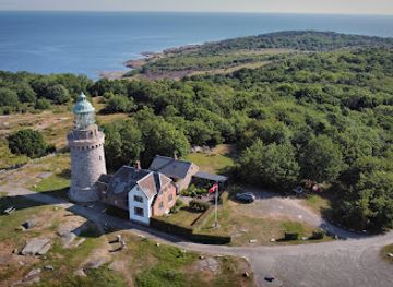
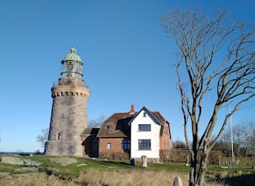
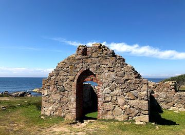
Wild granite cliffs, heather hills and Baltic Sea vistas meet lakes, quarries and a historic lighthouse at Bornholm’s rugged northern headland.

4.9

Hammeren crowns the northern tip of Bornholm with a dramatic granite headland of cliffs, heather‑clad hills and open sea views. This protected nature reserve near Allinge-Sandvig is criss-crossed by walking trails that weave between rocky coastline, grazing livestock, tranquil Hammersø lake and the historic Hammeren lighthouse. It is a compact but wonderfully varied landscape, ideal for half-day hikes, coastal photography and quiet encounters with Bornholm’s wild, wind-shaped scenery.

A brief summary to Hammeren

  • Allinge, DK
  • Duration: 1.5 to 4 hours
  • Free
  • Environment icon Outdoor
  • Mobile reception: 4 out of 5
  • Monday 12 am-12 am
  • Tuesday 12 am-12 am
  • Wednesday 12 am-12 am
  • Thursday 12 am-12 am
  • Friday 12 am-12 am
  • Saturday 12 am-12 am
  • Sunday 12 am-12 am

Local tips

  • Wear sturdy shoes: many paths cross uneven granite, short steep sections and cliffside tracks that can be slippery when wet.
  • Bring windproof layers even in summer; the exposed headland often feels significantly cooler than nearby villages.
  • Pack water and snacks, as there are no shops inside the reserve and facilities are concentrated back in Sandvig and Allinge.
  • If you want quieter trails, start early in the day and explore the inland routes around Hammersø and Opalsø before circling to the coast.
  • Respect grazing animals by walking calmly around them, keeping dogs leashed and closing any gates you pass through.
widget icon

Getting There

  • Local bus from Rønne

    From Rønne, take a regional bus towards Allinge-Sandvig; services typically run at least hourly in high season and less frequently in winter. The ride to Sandvig takes around 45–60 minutes and costs roughly 40–60 DKK one way, depending on ticket type. From the bus stop in Sandvig it is about 20–30 minutes on foot along signed paths and local roads to reach the main trailheads at Hammeren. Buses are standard city-style vehicles with low-floor access, but the final approach through the reserve involves uneven ground.

  • Bicycle from Allinge-Sandvig

    Hammeren is easily combined with a coastal cycling route starting in Allinge or Sandvig. From the harbour area, allow 15–25 minutes of relaxed cycling to reach the edge of the nature reserve, using shared roads and signposted cycle paths. Standard rental bikes on Bornholm typically cost about 100–150 DKK per day. Once at Hammeren you must leave the bike at designated areas or roadside spots and continue on foot, as most trails across the headland are not suitable for cycling.

  • Car or taxi from elsewhere on Bornholm

    By car, Hammeren lies roughly 30–40 minutes from Rønne via the island’s main roads, depending on traffic and starting point. Expect to pay around 500–700 DKK for a one-way taxi from Rønne to Allinge-Sandvig. Public parking areas near the headland can fill up in peak summer and may have time limits, so avoid arriving late in the day if you plan a longer hike. From parking spots you should be prepared to walk on undulating, occasionally steep paths to explore the reserve.

Hammeren location weather suitability

  • Weather icon Clear Skies
  • Weather icon Mild Temperatures
  • Weather icon Windy Conditions
  • Weather icon Hot Weather
  • Weather icon Cold Weather
  • Weather icon Any Weather

Unlock the Best of Hammeren

Buy tickets

    No tickets available

Book tours with entry

    No tours available

Book tours without entry

    No tours available

Discover more about Hammeren

Granite Headland at the Edge of Bornholm

Hammeren forms the hammer-shaped northern tip of Bornholm, a self-contained granite peninsula rising dramatically above the Baltic Sea. The plateau climbs to around 80 metres near Hammeren lighthouse, giving you a sense of elevation that is unusual in Denmark and creating sweeping views along the wild coastline. Walking paths fan out across the headland, some threading inland through gently rolling rock and heath, others hugging the outer rim where the cliffs drop sharply to the sea. The landscape is defined by exposed bedrock sculpted by ice and waves, creating ledges, fissures and rounded granite domes. Low, wind-bent shrubs cling to the rock, while pockets of grassland soften the terrain. From many points you can gaze south towards the ruins of Hammershus Castle and, on clear days, all the way across the water to Sweden.

Trails, Lakes and a Former Quarry

A network of waymarked routes lets you shape your own experience, from short strolls to more demanding circuits linking Hammeren with Sandvig and Hammershus. Inland paths pass Hammersø, the island’s largest lake, lying in a rift-like valley that separates the headland from the rest of Bornholm. The still water, framed by rock walls and greenery, provides a serene counterpoint to the restless sea just over the ridge. On the eastern side, an old granite quarry has filled with clear water to form Opalsø, a striking turquoise basin ringed by sheer rock faces. In summer, the area has a playful side with seasonal activities such as a zip line across the water, while the quarry walls showcase the area’s industrial past. The combination of former working landscapes and now-protected nature gives Hammeren a layered character that rewards slow exploration.

Hammeren Lighthouse and Sea Views

Perched close to the highest point of the headland, Hammeren lighthouse is one of the peninsula’s most recognisable features. Built in the 19th century from the very granite beneath your feet, it stands as a solid landmark against the sky. When open, you can climb the tower and look out over all of North Bornholm, tracing the curve of the coastline and the jagged sequence of cliffs and bays. Even without going inside, the area around the lighthouse offers expansive viewpoints. Paths loop past the building to reach cliff edges and rocky outcrops where you can watch ships on the Baltic and feel the often-brisk coastal wind. Sunsets here can be particularly atmospheric, with the light catching the rough stone and heather in shifting colours.

Wildlife, Grazing Animals and Plant Life

Despite its relatively small size, Hammeren shelters a variety of habitats, from dry heath and rocky slopes to wetland edges around the lakes. Areas of the reserve are grazed by livestock, which help keep the vegetation open and preserve the traditional, semi-natural landscape. Encountering sheep or cattle on narrow paths is part of the experience, reinforcing the feeling of being in a living cultural landscape rather than a manicured park. The cliffs and offshore rocks attract seabirds, and the peninsula is an appealing spot for casual birdwatching. In late summer, carpets of purple heather colour the hillsides, while lichens and hardy grasses cling to cracks in the granite. The mix of raw rock and delicate plant life gives the reserve a distinctive texture at close range.

Hiking Atmosphere and Practical Impressions

Underfoot, many trails follow uneven stone, earth and occasionally steep sections, so sturdy footwear is advisable even for shorter walks. Wayfinding is generally straightforward, with clear paths linking the lighthouse, lakes, quarry and coastal viewpoints, yet it is easy to find quieter corners away from the main junctions. Benches and informal resting spots appear at some viewpoints, but the area otherwise feels pleasingly untamed. The coastal climate can shift quickly, from bright sun and clear visibility to low cloud or sea mist, making flexible layers and windproof clothing useful for most of the year. Whether you come for a focused hike between Sandvig and Hammershus or simply wander out onto the headland for an hour, Hammeren delivers a strong sense of Bornholm’s geology, light and sea in a compact, memorable setting.

Busiest months of the year

Busiest hours of the day

Popular Experiences near Hammeren

Popular Hotels near Hammeren

Select Currency