

Delaware Water Gap National Recreation Area Travel Guide - Free Web & App
Your ultimate guide to Delaware Water Gap National Recreation Area. Discover top landmarks, proposed trips, and local tips. Free on the web or via the Evendo companion app.


Delaware Water Gap National Recreation Area in the United States offers river scenery, Appalachian trails, historic villages, waterfalls and four-season outdoor adventures.
A River Through the Appalachians
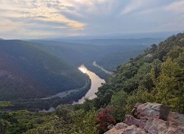
Delaware Water Gap National Recreation Area follows more than 40 miles of the Delaware River along the New Jersey–Pennsylvania border, where the waterway cuts through the forested Kittatinny Ridge at the landmark known as the Delaware Water Gap. The recreation area protects a broad landscape of wooded mountains, river islands, streams, wetlands, open farmland and historic settlements, rather than a single compact park site. Its New Jersey side includes access points around Walpack Valley, Millbrook Village, Old Mine Road and the eastern approaches to the river, while many major trails and viewpoints lie across the state line in Pennsylvania.Read more about Delaware Water Gap National Recreation Area
Trails, Water and Wildlife
Rural Heritage and Gateway Communities
When is the best time to visit Delaware Water Gap National Recreation Area?
Best: June, August–September · 23–27°C| Month | High (°C) | Rainfall (mm) |
|---|---|---|
| January | 3 | 83 |
| February | 5 | 75 |
| March | 9 | 100 |
| April | 15 | 103 |
| May | 21 | 110 |
| June (best) | 26 | 113 |
| July | 28 | 119 |
| August (best) | 27 | 120 |
| September (best) | 23 | 109 |
| October | 17 | 96 |
| November | 10 | 95 |
| December | 4 | 92 |
Getting to and around Delaware Water Gap National Recreation Area
How to get there
Transportation
Best attractions in Delaware Water Gap National Recreation Area
The recreation area's principal attraction is the Delaware Water Gap itself, where the river passes through Kittatinny Ridge between New Jersey and Pennsylvania. Hikers can tackle the Appalachian Mountain Trail and reach viewpoints including Mount Tammany, while easier riverside and woodland routes offer a quieter introduction to the landscape. Dingmans Falls and Raymondskill Falls are among the best-known waterfall destinations, although access and trail conditions should be checked before visiting. Sunfish Pond, a glacially formed lake on the Appalachian Trail, combines a distinctive natural setting with a demanding mountain approach. On the New Jersey side, Walpack Valley, Millbrook Village and sections of Old Mine Road reveal the area's agricultural and transport history. The river itself supports canoeing, kayaking, fishing and wildlife observation at suitable access points, while forests, wetlands and open fields provide habitat for bald eagles, black bears, deer and a broad range of birdlife.
-
State park
High Point State Park
Discover the breathtaking beauty and outdoor adventures at High Point State Park, New Jersey's highest point with panoramic views and diverse landscapes.
-
Wildlife refuge
Lakota Wolf Preserve
Explore the Lakota Wolf Preserve, a captivating wildlife refuge in New Jersey dedicated to the conservation of wolves and native species amidst stunning natural beauty.
-
Visitor center
Dingmans Falls Visitor Center
Explore the stunning natural beauty at Dingmans Falls Visitor Center, your gateway to the Delaware Water Gap's breathtaking landscapes and rich wildlife.
-
Park
Smithfield Beach
Experience the beauty of nature at Smithfield Beach, a perfect spot for swimming, picnicking, and hiking along the Delaware River.


Best landmarks in Delaware Water Gap National Recreation Area
The Delaware Water Gap is the defining natural landmark: a river-cut notch through Kittatinny Ridge that has served as both a landscape feature and a historic travel corridor. Mount Tammany provides one of the most recognisable elevated views towards the gap, while Sunfish Pond is a notable mountain lake associated with the Appalachian Trail. Dingmans Falls and Raymondskill Falls mark two of the area's best-known watercourses, with their wooded settings emphasising the region's steep relief and abundant streams. Old Mine Road is an important historic landscape feature, linking surviving traces of earlier transport and settlement. Millbrook Village preserves a group of historic buildings and rural structures that interpret nineteenth-century community life. Beyond these named sites, the Delaware River, forested ridges, wetlands and former farm fields together form the recreation area's most significant cultural and environmental landmark system.
-
Tourist attraction
Millbrook Village Historic Site
Explore the enchanting Millbrook Village Historic Site, where 19th-century history meets stunning natural beauty in the heart of Delaware Water Gap.
-
Hiking area
Large Pile of Rocks
Explore the breathtaking Large Pile of Rocks on the Appalachian Trail, offering stunning views and a unique hiking experience in New Jersey's natural beauty.
-
Visitor center
Delaware Water Gap National Recreation Area Park Headquarters
Explore the breathtaking vistas and outdoor adventures at Delaware Water Gap National Recreation Area, Pennsylvania’s scenic natural retreat.
-
Historical place
Delaware View House
Explore the historic Delaware View House in Walpack Township, NJ, where nature meets rich history in a picturesque setting.


Explore Delaware Water Gap National Recreation Area on the map
Plan your trip on one map. See where the top attractions, landmarks, restaurants and hotels are, and book hotels and experiences in a few clicks.
Best hotels in Delaware Water Gap National Recreation Area
Best restaurants in Delaware Water Gap National Recreation Area
There is no concentrated restaurant district within Delaware Water Gap National Recreation Area, and visitors should plan meals around gateway communities rather than remote trailheads. Towns including Delaware Water Gap, Columbia, Blairstown, Milford and Dingmans Ferry provide the most practical choice of diners, cafés, delis, pubs and independent restaurants, while rural roads in the surrounding area also lead to general stores, farm shops and seasonal food outlets. Menus reflect the wider Delaware Valley and northeastern United States, with familiar American cooking, sandwiches, baked goods, locally sourced produce where available and casual meals suited to walkers and paddlers. Picnic areas and self-catered meals are useful for full days in the recreation area, but food storage is important because black bears inhabit the region. Check current opening arrangements, particularly outside the main summer and autumn periods.
-
National reserve
Delaware Water Gap National Recreation Area
Discover breathtaking landscapes and outdoor adventures at Delaware Water Gap National Recreation Area - a true natural gem in Pennsylvania.

Best bars in Delaware Water Gap National Recreation Area
Evening entertainment is quiet and dispersed rather than centred on nightclubs. Traditional pubs, taverns and restaurants in gateway communities such as Delaware Water Gap, Milford, Blairstown and Columbia provide places for an evening meal or drink, while some accommodation businesses in the surrounding countryside offer a more subdued hospitality atmosphere. Seasonal community events, live music and cultural programmes may occur in nearby towns, but schedules vary and should be checked locally. Within the recreation area itself, darkness, wooded terrain and limited facilities make stargazing, riverside quiet and evenings at established accommodation more characteristic than organised nightlife. Visitors should arrange transport before drinking, since rural roads, limited public transport and dispersed settlements make spontaneous late-night travel impractical.
-
Restaurant
Alaska Pete's
Discover the culinary delights of Alaska Pete's, where fresh seafood, juicy steaks, and a warm atmosphere await in East Stroudsburg, Pennsylvania.
-
American
The Walpack Inn
Discover the exquisite flavors of American cuisine at The Walpack Inn, a scenic dining experience nestled in New Jersey's natural beauty.
-
Grill
Minisink Hotel
Discover the rustic charm and delicious American cuisine at Minisink Hotel, a hidden gem in the heart of Minisink Hills.
-
Brewpub
The Gem and Keystone Tavern
Experience the charm of The Gem and Keystone Tavern, a brewpub offering exquisite craft beers and delicious comfort food in beautiful Shawnee, PA.


Best shops in Delaware Water Gap National Recreation Area
Shopping within the recreation area is limited and mainly practical, with visitors relying on nearby towns for food, supplies, outdoor equipment and locally produced goods. Gateway communities such as Milford, Delaware Water Gap, Blairstown and Columbia contain independent shops, galleries, cafés, general stores and businesses serving hikers, paddlers and rural residents. Farm shops and seasonal stands in the surrounding Delaware Valley may offer produce, baked goods, preserves and other regional foods, while local galleries and craft businesses provide art and handmade items when open. There is no extensive shopping centre or continuous retail street inside the protected landscape, and remote trailheads have few facilities. Visitors planning a long walk, river outing or picnic should obtain essentials before entering the recreation area and should not assume that a particular small shop or seasonal stall will be operating.
-
National reserve
Delaware Water Gap National Recreation Area
Experience the stunning landscapes and outdoor adventures at Delaware Water Gap National Recreation Area, a natural gem in Pennsylvania.
-
Toy store
Pandora's Box Toys & Collectibles
Explore a nostalgic treasure trove of toys, comics, and collectibles at Pandora's Box Toys & Collectibles in Lafayette, NJ.
-
Canoe & kayak rental service
Adventure Sports
Explore East Stroudsburg's Adventure Sports for canoeing, kayaking, skiing, and snowboarding rentals amidst stunning natural beauty.
-
Furniture store
The Open Box Shop
Explore The Open Box Shop in Andover, NJ for unique furniture and home goods that bring style and comfort to your living space.


Get your free copy of our complete guide to Delaware Water Gap National Recreation Area, delivered straight to you.
Everything on this page, from attractions and restaurants to essentials and local phrases, in one PDF you can read offline, print or share.
Already have an account? Sign in
Your Delaware Water Gap National Recreation Area guide is ready.
We'll send it to · Not you? Sign out

Getting your guide ready…
We are putting together a fresh copy of the Delaware Water Gap National Recreation Area guide. This can take up to a minute.
This can take a few moments. If your browser asks, choose Allow so the download can start. You'll find the guide in your Downloads folder.
Nothing happened? Download it again
Sorry, the guide is taking longer than usual. Please try again in a minute, or get it by email instead.
Delaware Water Gap National Recreation Area essentials
Currency and Payment
Safety
Emergency Situations
Do's and Don'ts
Local Tips
From Eve
Local phrases worth knowing
You don't need to get them perfect. A few words go a long way, and locals appreciate the effort.
Basics
| English | Local | Say it |
|---|---|---|
| Hello | Howdy | [h-ou-d-ee] |
| Goodbye | See ya | [s-ee y-ah] |
| Yes | Yup | [y-uh-p] |
| No | Nah | [n-ah] |
| Please/You're welcome | Please/No worries | [pl-ee-z/n-oh w-ur-ee-z] |
| Thank you | Thanks | [th-anks] |
| Excuse me/Sorry | Pardon me/My bad | [p-ar-d-uhn m-ee/m-ahy b-ad] |
| How are you? | How you doin'? | [h-ou y-oo d-oh-in] |
| Fine. And you? | A-OK. How 'bout you? | [ey-oh-k-ey. h-ow b-uh-t y-oo] |
| Do you speak English? | Ya speak English? | [y-ah sp-ee-k ing-g-lish] |
| I don't understand | I ain't gettin' ya | [ai d-oh-nt uh-nd-er-st-and] |
Eating & Drinking
| English | Local | Say it |
|---|---|---|
| I'd like to see the menu, please | Show me the grub, would ya? | [sh-oh m-ee th-uh gr-uh-b, w-oo-d y-ah] |
| I don't eat meat | I ain't a meat eater | [ai ai-nt ah m-ee-t ee-t-er] |
| Cheers! | Salut! | [s-ah-l-uh-t] |
| I would like to pay, please | Cash me out, if ya could | [k-ash m-ee out, ihf y-ah k-oo-d] |
Emergencies
| English | Local | Say it |
|---|---|---|
| Help! | SOS! | [es-oh-es] |
| Go away! | Scram! | [sk-r-am] |
| Call the Police! | Get the cops! | [g-et th-uh k-ah-ps] |
| Call a doctor! | Get a doc! | [g-et ah d-ok] |
| I'm lost | I'm all turned around | [ai'm aw-l t-ur-n-d aw-r-aw-nd] |
| I'm ill | I ain't feelin' so good | [ai ai-nt f-ee-l-in s-oh g-oo-d] |
Shopping
| English | Local | Say it |
|---|---|---|
| I'd like to buy... | I wanna snag... | [ai w-ah-n-ah sn-ah-g] |
| I'm just looking | Just browsin' | [j-uh-st br-ow-s-in] |
| How much is it? | What's the damage? | [w-ah-ts th-uh d-am-ah-j] |
| That's too expensive | That's a rip-off | [th-ats ah r-ip-aw-f] |
| Can you lower the price? | Can ya knock a few bucks off? | [k-ah-n y-ah n-oh-k ah f-y-oo b-uh-ks aw-f] |
Time & Numbers
| English | Local | Say it |
|---|---|---|
| What time is it? | What's the time? | [w-ah-ts th-uh t-ah-y-m] |
| It's one o'clock | It's one | [it-s w-ah-n] |
| Half past (10) | Half ten | [h-ah-f t-eh-n] |
| Morning | Mornin' | [m-awr-n-in] |
| Afternoon | Arvo | [ah-r-v-oh] |
| Evening | Night | [n-ah-y-t] |
| Yesterday | Yest'day | [y-eh-st-d-ay] |
| Today | Today | [t-uh-day] |
| Tomorrow | Tomorra | [t-oh-m-or-ah] |
| 1 | One | [w-uhn] |
| 2 | Two | [t-oo] |
| 3 | Three | [th-r-ee] |
| 4 | Four | [f-aw-r] |
| 5 | Five | [f-ahy-v] |
| 6 | Six | [s-ih-k-s] |
| 7 | Seven | [s-eh-v-eh-n] |
| 8 | Eight | [ey-t] |
| 9 | Nine | [n-ah-y-n] |
| 10 | Ten | [t-eh-n] |
Transport & Directions
| English | Local | Say it |
|---|---|---|
| Where's a/the...? | Where's the... | [w-ehr-s th-uh] |
| What's the address? | What's the addy? | [w-ah-ts th-uh a-d-ee] |
| Can you show me (on the map)? | Can ya point it out (on the map)? | [k-ah-n y-ah p-oy-nt ih-t aw-t (aw-n th-uh m-ah-p)] |
| When's the next (bus)? | When's the next one? | [w-eh-n-s th-uh n-eh-k-s-t w-ahn] |
| A ticket (to ....) | A pass (to ....) | [ah p-ah-s (t-oo ....)] |
History of Delaware Water Gap National Recreation Area
River Gorge and Ancient Ridge
The Delaware Water Gap is a natural passage cut by the Delaware River through Kittatinny Ridge, part of the Appalachian landscape. The ridge and surrounding valleys reflect immense geological change over deep time, while the river continues to shape the gorge and its floodplain. This physical corridor later influenced travel, settlement and industry, making the gap more than a scenic feature: it became a route through the mountains linking communities on either side of the river.
Indigenous Homelands and Early Settlement
Before European colonisation, the Delaware Valley was inhabited by Indigenous peoples, including communities associated with the Lenape. The river supplied fish, transport and fertile lowland resources, while the surrounding forests supported hunting and gathering. European settlement brought farms, mills, roads and changing land ownership. The resulting landscape combined small agricultural communities with woodland and river commerce, patterns whose traces remain in abandoned settlements, field boundaries, cemeteries and historic structures.
Old Mine Road and Local Industry
Old Mine Road follows a historic corridor along the Delaware and is commonly associated with early European movement and the region's colonial-era mining activity. During the eighteenth and nineteenth centuries, agriculture, timber, milling, quarrying and iron-related industries shaped settlements on both sides of the river. Water power supported mills, while roads and the river connected remote valleys to wider markets. Some historic buildings and routes survive within the recreation area, although the landscape is now primarily experienced as public conservation land.
The Tocks Island Controversy
In the twentieth century, a proposed dam at Tocks Island threatened to flood a large section of the Delaware Valley for a water-supply reservoir. Homes and farms were acquired, and many residents left, but strong local opposition and changing federal priorities eventually halted the project. Congress established Delaware Water Gap National Recreation Area in 1965, transforming the disputed valley into a national recreation landscape. The abandoned proposal still influences the area's character, with former settlement sites and an unusually broad protected river corridor.
Conservation and Public Recreation
Since its creation, the recreation area has balanced public access with the protection of river, forest, wildlife habitat and cultural resources. The National Park Service manages trails, historic properties, river accesses and visitor facilities across a landscape shared with surrounding communities and neighbouring public lands. Conservation priorities include water quality, erosion control, habitat protection and the stewardship of historic buildings. Recreation has expanded around hiking, paddling, fishing, birdwatching and scenic driving without erasing the area's agricultural and village history.
Delaware Water Gap National Recreation Area in Photos
Browse through our photo collection highlighting the charm and character of the destination.
Neighbouring destination travel guides
The closest destinations to Delaware Water Gap National Recreation Area, if you have time for more than one.
-

-

-

-

-


Swipe for more destinations
Explore more
Explore more of Skylands Region
Explore New Jersey's Skylands for Appalachian trails, glacial lakes, Revolutionary history, farm markets and scenic towns near New York City.
Explore Skylands Region
Explore more of New Jersey
Discover New Jersey: From vibrant cities and historic towns to scenic beaches and lush parks, the Garden State offers a rich blend of culture, nature, and adventure.
Explore New Jersey