

Delaware Water Gap National Recreation Area Travel Guide - Free Web & App
Your ultimate guide to Delaware Water Gap National Recreation Area. Discover top landmarks, proposed trips, and local tips. Free on the web or via the Evendo companion app.


Delaware Water Gap National Recreation Area blends Appalachian trails, waterfalls, river beaches, wildlife and historic sites on Pennsylvania's scenic border.
A River Through the Appalachians
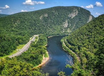
Delaware Water Gap National Recreation Area protects more than 40 miles of the Delaware River and a broad landscape of forested ridges, wooded valleys, waterfalls, historic farms and former canal communities along the Pennsylvania–New Jersey border. Its defining feature is the Delaware Water Gap, where the river cuts through Kittatinny Mountain, creating a natural passage in the Appalachian landscape. Although the recreation area is administered as a single National Park Service unit, its river corridor and many access points extend across both states.Read more about Delaware Water Gap National Recreation Area
Landscape and Wildlife
History and Rural Character
When is the best time to visit Delaware Water Gap National Recreation Area?
Best: June, August–September · 23–28°C| Month | High (°C) | Rainfall (mm) |
|---|---|---|
| January | 4 | 73 |
| February | 5 | 64 |
| March | 10 | 86 |
| April | 16 | 89 |
| May | 21 | 95 |
| June (best) | 26 | 99 |
| July | 28 | 100 |
| August (best) | 28 | 103 |
| September (best) | 23 | 92 |
| October | 17 | 84 |
| November | 10 | 82 |
| December | 4 | 78 |
Getting to and around Delaware Water Gap National Recreation Area
How to get there
Transportation
Best attractions in Delaware Water Gap National Recreation Area
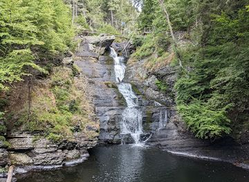
The Delaware River and the wooded mountains around it form the recreation area's main attractions, with the Delaware Water Gap providing its most recognisable landscape. On the Pennsylvania side, Mount Minsi trails look across the river to Mount Tammany, while the Appalachian Trail follows the Kittatinny ridge through both states. Dingmans Falls and Raymondskill Falls offer two of the area's best-known waterfall walks, although paths and access can vary with weather and park conditions. Van Campens Glen presents a shaded New Jersey ravine, and the historic Millbrook Village interprets a former rural community through preserved buildings and landscape. River beaches and access points support seasonal recreation where permitted, while the Delaware and Lehigh National Heritage Corridor connects some nearby canal-related features beyond the recreation area's immediate sites. Forest roads, old farmsteads, tributary valleys and broad river views make the destination as much about moving between contrasting landscapes as visiting individual attractions.
-
Hiking area
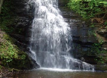
Bushkill Falls
Experience the breathtaking beauty of Bushkill Falls, a premier hiking area and picnic ground in Pennsylvania's Pocono Mountains, perfect for nature lovers and outdoor enthusiasts.
-
Zoo
Pocono Snake & Animal Farm
Discover the interactive wildlife experience at Pocono Snake & Animal Farm, a unique zoo in Pennsylvania perfect for families and animal lovers.
-
Tourist attraction
Raymondskill Falls
Experience the breathtaking beauty of Raymondskill Falls, the highest waterfall in Pennsylvania, surrounded by stunning landscapes and outdoor adventures.
-
Visitor center
Dingmans Falls Visitor Center
Explore the natural wonders of Dingmans Falls Visitor Center, your gateway to breathtaking waterfalls and scenic trails in Pennsylvania.



Explore Delaware Water Gap National Recreation Area on the map
Plan your trip on one map. See where the top attractions, landmarks, restaurants and hotels are, and book hotels and experiences in a few clicks.
Best hotels in Delaware Water Gap National Recreation Area
Best restaurants in Delaware Water Gap National Recreation Area
Dining within the recreation area is limited and dispersed rather than organised around a central village, so visitors usually eat in nearby gateway communities or bring provisions for a day outdoors. Delaware Water Gap, Stroudsburg and East Stroudsburg provide the broadest choice on the Pennsylvania side, while Milford and communities along the New Jersey approaches also offer places to eat outside the park boundary. Regional food reflects the wider northeastern Pennsylvania and Delaware Valley setting, with American diner cooking, casual cafés, pizzerias, traditional taverns and farm-linked produce more characteristic than a single signature cuisine. Local breweries, bakeries, seasonal farm stands and Pennsylvania Dutch-influenced foods may appear in the surrounding region, but availability varies by settlement and season. Packaged lunches are useful for remote trailheads, where there may be no café, shop or reliable opportunity to buy food nearby.
-
National reserve
Delaware Water Gap National Recreation Area
Explore Delaware Water Gap National Recreation Area: A breathtaking blend of nature's beauty with endless outdoor adventures.
-
 Campground
Delaware Water Gap / Pocono Mountain KOA Holiday
Discover outdoor adventures and serene landscapes at Delaware Water Gap / Pocono Mountain KOA Holiday – your gateway to nature's beauty.
-
Pizza
Marlucas
Discover Marlucas in Bushkill, PA – where delicious pizza meets warm hospitality amidst beautiful Pocono Mountains scenery.
-
Park
Delaware Watergap National Recreation Area
Explore breathtaking landscapes and outdoor adventures at Delaware Water Gap National Recreation Area – where nature meets history.


Best bars in Delaware Water Gap National Recreation Area
Evening entertainment is modest and centred on the surrounding towns rather than the recreation area's forests and river accesses. Delaware Water Gap and the Stroudsburg–East Stroudsburg area provide the most established choice of pubs, taverns, casual bars and occasional live-music settings, while Milford offers a quieter small-town evening atmosphere. Rural inns and restaurants near the park may serve drinks with meals, but opening patterns and entertainment offerings vary, particularly outside the busier summer period. Within the recreation area itself, darkness, dispersed facilities and protected landscape management mean that nightlife is not a defining feature; evenings are more commonly spent at accommodation, around a permitted campsite setting where authorised, or observing the river and forest in quieter conditions. Arrange transport before drinking, as distances between communities and visitor sites are substantial.
-
National reserve
Delaware Water Gap National Recreation Area
Explore the stunning landscapes and rich history of Delaware Water Gap National Recreation Area, a must-visit destination for nature lovers and outdoor enthusiasts.
-
Grill
Minisink Hotel
Discover the cozy charm of Minisink Hotel, an American grill offering mouthwatering dishes in a welcoming atmosphere, perfect for post-hike dining.
-
Brewpub
The Gem and Keystone Tavern
Discover the charm of The Gem and Keystone Tavern, a premier brewpub in Shawnee on Delaware, PA, offering local brews and delicious food in a cozy setting.
-
Campground
Delaware Water Gap / Pocono Mountain KOA Holiday
Discover the serene beauty of Delaware Water Gap / Pocono Mountain KOA Holiday, where outdoor adventures and family fun await amidst breathtaking landscapes.


Best shops in Delaware Water Gap National Recreation Area
Shopping inside the recreation area is limited, with no large commercial centre and only scattered opportunities associated with visitor facilities or nearby communities. Delaware Water Gap, Stroudsburg and East Stroudsburg are the most practical Pennsylvania bases for groceries, outdoor supplies, independent businesses and everyday provisions, while Milford serves visitors exploring the northern end and nearby New Jersey settlements provide additional options across the river. Farm stands, local food producers, galleries, craft businesses and seasonal markets appear in the wider Delaware Valley, though they are not uniformly available throughout the year. Regional purchases may include honey, preserves, baked goods, produce, locally made artwork and practical outdoor equipment, but visitors should not assume a particular product or market will be operating. Buy supplies before reaching remote trailheads and treat historic structures, natural materials and archaeological objects as things to observe rather than souvenirs.
-
National reserve
Delaware Water Gap National Recreation Area
Discover the breathtaking landscapes and outdoor adventures awaiting you at Delaware Water Gap National Recreation Area.
-
Visitor center
Delaware Water Gap National Recreation Area Park Headquarters
Discover the breathtaking landscapes and outdoor adventures at Delaware Water Gap National Recreation Area, a must-visit destination for nature lovers.
-
Park
Delaware Watergap National Recreation Area
Discover the breathtaking landscapes and endless adventures at Delaware Water Gap National Recreation Area, where nature meets excitement.


Get your free copy of our complete guide to Delaware Water Gap National Recreation Area, delivered straight to you.
Everything on this page, from attractions and restaurants to essentials and local phrases, in one PDF you can read offline, print or share.
Already have an account? Sign in
Your Delaware Water Gap National Recreation Area guide is ready.
We'll send it to · Not you? Sign out

Getting your guide ready…
We are putting together a fresh copy of the Delaware Water Gap National Recreation Area guide. This can take up to a minute.
This can take a few moments. If your browser asks, choose Allow so the download can start. You'll find the guide in your Downloads folder.
Nothing happened? Download it again
Sorry, the guide is taking longer than usual. Please try again in a minute, or get it by email instead.
Delaware Water Gap National Recreation Area essentials
Currency and Payment
Safety
Emergency Situations
Do's and Don'ts
Local Tips
From Eve
Local phrases worth knowing
You don't need to get them perfect. A few words go a long way, and locals appreciate the effort.
Basics
| English | Local | Say it |
|---|---|---|
| Hello | Howdy | [haw-dee] |
| Goodbye | See ya | [see yah] |
| Yes | Yep | [yep] |
| No | Nah | [nah] |
| Please/You're welcome | Please and thank ya | [pleez and thank yah] |
| Thank you | Thanks a lot | [thanks uh lot] |
| Excuse me/Sorry | Pardon me | [pahr-dn me] |
| How are you? | How ya doin'? | [how yah doin] |
| Fine. And you? | I'm good. How 'bout y'all? | [I'm good. How 'bout yall] |
| Do you speak English? | Ya speak English? | [yah speak English] |
| I don't understand | I don't git it | [I don't get it] |
Eating & Drinking
| English | Local | Say it |
|---|---|---|
| I'd like to see the menu, please | Kin I see the menu, please | [kin I see the menu please] |
| I don't eat meat | I don't eat meat | [I don't eat meat] |
| Cheers! | Cheers! | [Cheers] |
| I would like to pay, please | I'd like to pay, please | [I'd like to pay please] |
Emergencies
| English | Local | Say it |
|---|---|---|
| Help! | Help! | [Help] |
| Go away! | Git outta here! | [Git outta here] |
| Call the Police! | Call the Cops! | [Call the Cops] |
| Call a doctor! | Call a doc! | [Call a doc] |
| I'm lost | I'm lost | [I'm lost] |
| I'm ill | I'm sick | [I'm sick] |
Shopping
| English | Local | Say it |
|---|---|---|
| I'd like to buy... | I wanna buy... | [I wanna buy] |
| I'm just looking | Just browsin' | [just browsin] |
| How much is it? | How much fer it? | [how much fur it] |
| That's too expensive | That's too pricey | [That's too pricey] |
| Can you lower the price? | Can ya knock the price down? | [Can yuh knock the price down] |
Time & Numbers
| English | Local | Say it |
|---|---|---|
| What time is it? | What time is it? | [What time is it] |
| It's one o'clock | It's one o'clock | [It's one o'clock] |
| Half past (10) | Half past ten | [Half past ten] |
| Morning | Mornin' | [Mornin] |
| Afternoon | Afternoon | [Afternoon] |
| Evening | Evenin' | [Evenin] |
| Yesterday | Yest'day | [Yest'day] |
| Today | Today | [Today] |
| Tomorrow | Tomorrow | [Tomorrow] |
| 1 | One | [One] |
| 2 | Two | [Two] |
| 3 | Three | [Three] |
| 4 | Four | [Four] |
| 5 | Five | [Five] |
| 6 | Six | [Six] |
| 7 | Seven | [Seven] |
| 8 | Eight | [Eight] |
| 9 | Nine | [Nine] |
| 10 | Ten | [Ten] |
Transport & Directions
| English | Local | Say it |
|---|---|---|
| Where's a/the...? | Where's the...? | [Where's the] |
| What's the address? | What's the address? | [What's the address] |
| Can you show me (on the map)? | Can ya show me (on the map)? | [Can yuh show me (on the map)] |
| When's the next (bus)? | When's the next (bus)? | [When's the next (bus)] |
| A ticket (to ....) | A ticket (to ....) | [A ticket (to)] |
History of Delaware Water Gap National Recreation Area
A River Shaped by Geology
The Delaware Water Gap is a natural opening through Kittatinny Mountain, formed over geological time as the Delaware River cut across the resistant ridge. The surrounding Appalachian ridges, valleys and ravines reflect the region's long erosion history and provide the physical framework for the modern recreation area. The river corridor links upland forest with low-lying floodplain, while tributary streams have created narrow wooded valleys and waterfalls. This geological setting later made the gap an important route for travel, settlement and trade, helping to give the area significance beyond its scenery.
Lenape Homeland and Colonial Settlement
Before European colonisation, the Delaware Valley was part of the homeland of Lenape people, whose lives were closely connected with the river, forests and productive valley lands. European settlement brought farms, roads and mills, followed by changing patterns of land ownership and resource use. The river became both a source of sustenance and a transport corridor, while communities developed on both sides of the water. Many modern place names and the name Delaware itself reflect the river's enduring centrality, although the landscape's Indigenous history is older than the surviving colonial buildings and farms.
Canals, Farms and River Commerce
During the nineteenth century, the Delaware and Hudson Canal connected the Hudson River with Pennsylvania's anthracite coal regions, carrying coal eastward and bringing commercial activity into the Delaware Valley. Canal remnants, towpaths and associated settlements preserve evidence of this era, when waterways were essential to regional industry before the dominance of railways and improved roads. Farming remained important in the river valleys, and small communities combined agricultural work with milling, commerce and transport. The surviving landscape of fields, stone structures and historic roads reflects this mixture of rural life and industrial connection.
Tourism and the Tocks Island Proposal
The Delaware Valley attracted leisure visitors as roads and automobile travel improved, with river recreation, fishing, hiking and scenery gradually becoming more prominent than canal transport and local industry. In the twentieth century, a proposal to build the Tocks Island Dam threatened to flood a substantial section of the valley and required the acquisition of many properties. Although the dam was never built, displacement and demolition altered communities and left a complicated legacy. The controversy also helped focus national attention on the valley's recreational and environmental importance.
Creation of the National Recreation Area
Delaware Water Gap National Recreation Area was established in 1965 after the dam project had been authorised, and the National Park Service subsequently managed the river corridor as a large public recreation landscape. The unbuilt reservoir left a protected valley in which natural habitats, historic properties and public access could develop together. Conservation work now includes care for waterways, forests, trails, historic structures and culturally important landscapes, while recreation is managed across a wide area shared by Pennsylvania and New Jersey. Millbrook Village and canal-related remains help interpret the human history within this changing protected landscape.
Delaware Water Gap National Recreation Area in Photos
Browse through our photo collection highlighting the charm and character of the destination.
Neighbouring destination travel guides
The closest destinations to Delaware Water Gap National Recreation Area, if you have time for more than one.
-

-

-

-

-


Swipe for more destinations
Explore more
Explore more of Pocono Mountains
Explore Pennsylvania’s Pocono Mountains for forest trails, mountain lakes, historic towns, river scenery, skiing and four-season outdoor recreation.
Explore Pocono Mountains
Explore more of Pennsylvania
Discover Pennsylvania: A blend of rich history, breathtaking nature, and vibrant culture awaits you in the Keystone State.
Explore Pennsylvania