Background

Juvre Sand Military Area and Dyke

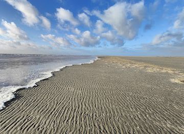
A vast off-limits tidal landscape at Rømø’s northern tip, where bird-filled Wadden Sea flats double as a Danish military training ground watched from a safe dyke-top perch.

4.5

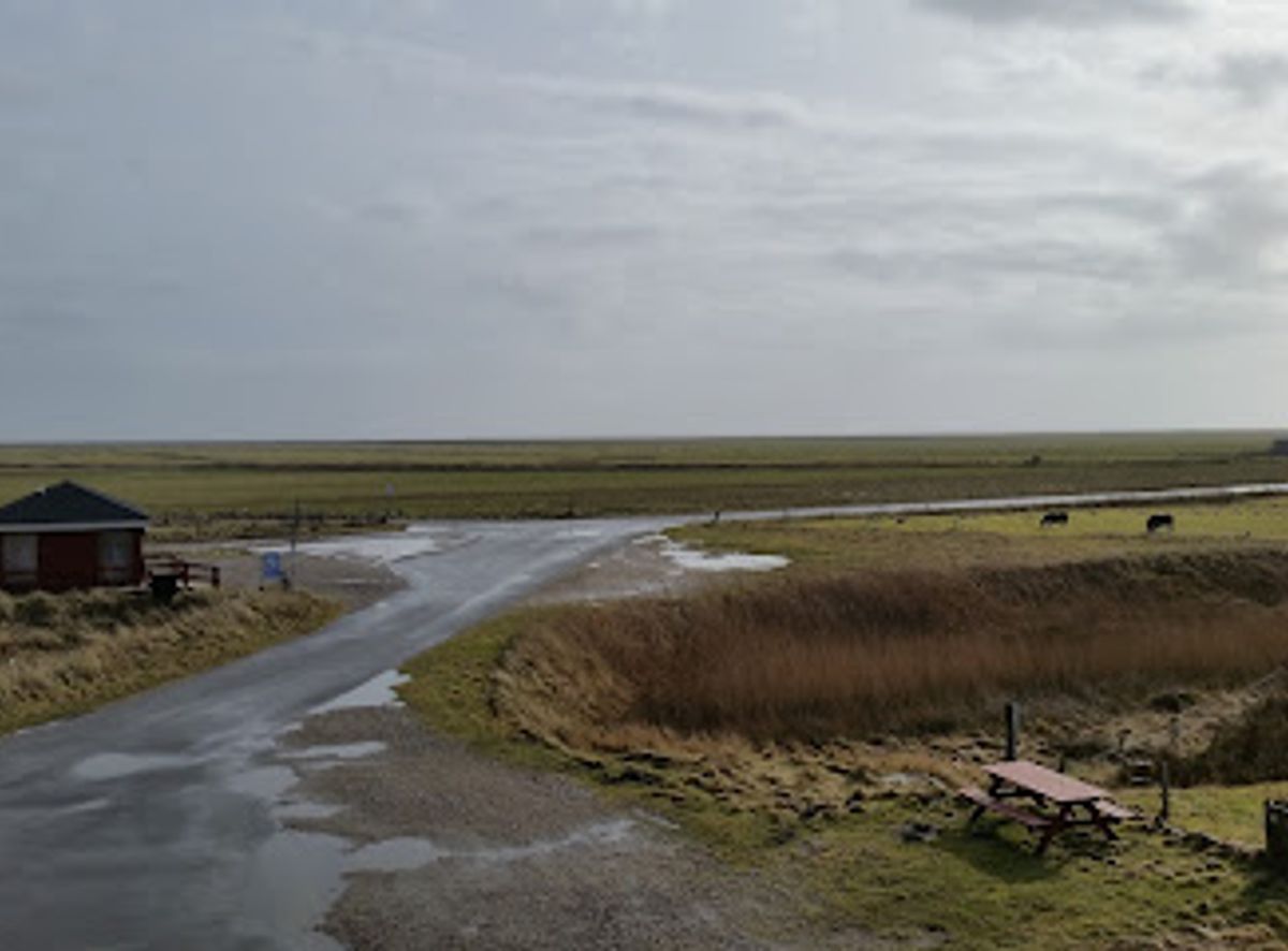
Juvre Sand occupies the remote northern tip of Rømø, a 20 km² expanse of tidal flats and dunes closed to public access and used as a Danish military training ground. While you cannot enter the sands themselves, an observation platform and the Juvre Dyke offer safe, elevated views over the exercise area, vast marshes and the Wadden Sea. It is a curious mix of raw coastal nature, birdlife and heavy equipment, framed by big skies and the ever‑changing tides.

A brief summary to Juvre Sand

  • Rømø, DK
  • Duration: 0.5 to 2 hours
  • Free
  • Environment icon Outdoor
  • Mobile reception: 3 out of 5

Local tips

  • Bring binoculars or a zoom lens to make the most of both distant military exercises and the abundant birdlife over the tidal flats and marshes.
  • Dress for strong coastal wind even in summer; the exposed observation platform and dyke can feel significantly cooler than sheltered parts of Rømø.
  • Obey all fences, signs and signal markers; access to Juvre Sand itself is permanently prohibited for safety and the only legal vantage is from permitted paths and the platform.
widget icon

Getting There

  • Car from central Rømø (Havneby area)

    Driving from the main holiday area around Havneby to the Juvre Sand observation platform typically takes 20–30 minutes. The route follows the island’s main north–south road through villages and open farmland before narrowing near Juvre. Expect mostly paved, well-maintained roads, but with some tight sections and oncoming traffic. There is free roadside or small lay-by parking near the dyke; in peak summer you may need to walk a few hundred metres along the embankment. Fuel stations are concentrated in the southern half of the island, so plan to fill up before heading north.

  • Car from Skærbæk on the mainland

    From Skærbæk on the Jutland mainland to northern Rømø, the drive generally takes 40–55 minutes, including the low-lying causeway over the Wadden Sea. The route is on standard Danish regional and local roads with speed limits between about 60 and 80 km/h, slowing through villages. There are no tolls; your main cost is fuel. In strong winds the causeway can feel exposed, and during very severe weather authorities can temporarily restrict traffic, so check local conditions in autumn and winter.

  • Public bus plus walking

    Regional buses link Skærbæk with several stops on Rømø, typically taking 30–40 minutes to reach the central and southern parts of the island. A one-way adult ticket usually falls in the range of 30–60 DKK depending on zones and concessions. From the nearest northern stop you should allow at least 45–60 minutes on foot or by bicycle to reach the Juvre Dyke and observation area, mainly along quiet village roads. Services are less frequent in the evening and at weekends, so check current timetables and be prepared for limited return options outside the main season.

  • Cycling on Rømø

    Cycling from mid-island areas such as Lakolk or Kongsmark to Juvre Sand often takes 45–75 minutes each way, depending on fitness and wind. The terrain is flat but exposed, and headwinds across the open fields can make the journey feel longer. Much of the route follows quiet local roads or signed cycle paths, though you will share some sections with cars. There is no fee for access, but bring lights in shoulder seasons when daylight is short, and be prepared with water and rain protection as there are few shelters along the northern stretches.

Juvre Sand location weather suitability

  • Weather icon Clear Skies
  • Weather icon Windy Conditions
  • Weather icon Mild Temperatures
  • Weather icon Cold Weather

Unlock the Best of Juvre Sand

Buy tickets

    No tickets available

Book tours with entry

    No tours available

Book tours without entry

    No tours available

Discover more about Juvre Sand

Between Wadden Sea Wilderness and Military Precision

Juvre Sand stretches across the northern tip of Rømø as a broad, low-lying apron of sand, mudflats and shallow channels that merge seamlessly into the Wadden Sea. At first glance it looks like pure coastal wilderness, but this 20 km² area has been set aside since the 1950s as a military training ground. Tanks, armored vehicles and aircraft use the flats for exercises, taking advantage of the soft, open landscape and big sky. The result is a place where seabirds, saltmarsh and modern technology coexist in a way you will not find elsewhere on the island. For visitors, the defining feature of Juvre Sand is its inaccessibility. The sands themselves are strictly off-limits year-round, both for safety and to protect the training zone. Instead, the experience is about looking in from the edge: tracing the line where dykes and grassy fields meet the raw, open flats, and watching the choreography of exercises unfold at a distance while the tide slides quietly in and out beyond.

Watching the Exercises from the Observation Platform

The focal point for experiencing Juvre Sand is a purpose-built observation platform on the northern side of Rømø. From this raised vantage you look out across a wide, almost featureless plain punctuated by mock targets, vehicle tracks and shallow pools. On training days the setting comes alive with the low rumble of engines, distant rotor noise or the crack of practice munitions, all framed by the calls of waders and gulls skimming the waterlogged ground. Clear visual signals indicate when exercises are active, and information boards near the platform explain both the military role of the area and the particular challenges of operating in tidal terrain. Even when training is paused, the platform is a striking place to appreciate scale: the horizon feels far away, the sky enormous, and the flatness emphasizes every change in light as clouds race over the sea.

Along the Juvre Dyke and Marshland Edge

Running south of the training ground, the long Juvre Dyke draws a firm line between the reclaimed grazing meadows of Juvre Enge and the wild tidal flats beyond. Walking or cycling along the dyke is permitted and offers a more tranquil way to sense the landscape around Juvre Sand without entering the restricted zone. From the grassy embankment you can watch flocks of geese and shorebirds feeding in the fields, then pivot to the emptier sweep of sand and mud on the seaward side. This part of Rømø tells the story of how people have shaped the island over the last century, reclaiming land from the sea while defending against storm surges. It is a contrast to the untamed feel of the exercise area: the neat dyke, drainage channels and grazing cattle foregrounded against a backdrop of untouched tidal wilderness used for decidedly modern purposes.

Echoes of the Wadden Sea and Hidden Histories

Although you cannot roam Juvre Sand itself, its setting within the wider Wadden Sea landscape is impossible to ignore. The same tidal forces that sculpt the training area have, over millennia, built Rømø from sandbanks into a habitable island. At low tide, the distant glimmer of wet mudflats reveals feeding grounds for countless migratory birds, while at high tide the sea sweeps in to erase vehicle tracks and freshen the pools. Offshore and under the sands, traces of older maritime stories have been discovered, including the remains of historic vessels linked to centuries of North Sea trade and seafaring. These finds underscore how long this shallow coastal zone has supported human activity, from wooden sailing ships to today’s armored vehicles.

Planning a Visit and Staying Safe at the Edge

A visit to Juvre Sand is about observation rather than action, and it pairs well with other northern Rømø sights such as the whalebone fence in nearby Juvre or birdwatching around local lakes and meadows. Expect strong winds, sudden squalls and quickly changing light; even on calm days the exposed platform can feel raw, especially outside summer. Warm, windproof layers are advisable for most of the year, and binoculars add a lot whether your interest lies in aircraft, birds or both. Respecting closures and boundaries here is essential. Fences, signage and raised signal markers clearly indicate the training perimeter and activity levels. Staying on permitted paths, dykes and the platform not only keeps you safe from unexploded ordnance and live exercises, it also helps limit disturbance to the birds and fragile saltmarsh that share this unusual corner of Rømø with the Danish armed forces.

Busiest months of the year

Busiest hours of the day

Popular Experiences near Juvre Sand

Popular Hotels near Juvre Sand

Select Currency