Background

Kalveboderne Bay

A long, sheltered bay between Amager and western Copenhagen, where marinas, open sky and evolving waterfronts create a quiet, lived-in maritime landscape.

★★★★★4.5 (13)

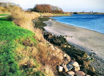
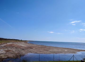
Kalveboderne is a long, sheltered stretch of water between the island of Amager and the western districts of Copenhagen, forming the city’s calm southern harbour and inner fjord-like bay. Fringed by marinas, nature areas and new canalside neighbourhoods, it offers a mix of sailing, kayaking, shoreline strolls and big-sky views, with the skyline of Copenhagen and low-lying Amager framing the horizon. It is more of a lived-in maritime landscape than a single viewpoint, rewarding slow exploration along its quays, paths and piers.

Plan your visit

A brief summary to Kalveboderne

Opening times, essentials, and a few local tips gathered into one calmer, easier-to-scan planning section.

Plan your visit

📍
DK
🕒
Duration: 1 to 4 hours
💷
Free
🏛
Outdoor
📶
Mobile reception: 4 out of 5

Explore places near Kalveboderne

    See all →

    Unlock the Best of Kalveboderne

    Find tickets, tours with entry, and experiences available for this location.

    Buy tickets

    No tickets available

    Book tours with entry

    No tours with entry available

    Book tours without entry

    No tours without entry available

    Getting There

    Train and walk

    From central Copenhagen, take an S-train on the A, E or H lines toward the southwestern suburbs and get off at a station such as Friheden or Avedøre. The ride typically takes 10–20 minutes, and standard zone tickets cost roughly 25–40 DKK depending on your starting point. From these stations, it is about a 15–30 minute walk to reach paths along the Kalveboderne shoreline, mostly on flat pavements and gravel embankments that are easy to manage in most weather.

    Metro and bus

    You can also approach Kalveboderne from the Amager side by taking the M1 or M2 metro from the city centre toward Amager stations such as Ørestad, which takes around 10–15 minutes and costs about 25–30 DKK. From there, local buses heading toward Vestamager or the southern harbour districts bring you closer to the bay in another 10–20 minutes. Services are frequent during the day, and most stops are within a short, level walk of the dikes and waterfront paths.

    Cycling

    For a more scenic approach, rent a bicycle in central Copenhagen and follow signposted cycle routes toward the South Harbour or Amager’s western edge. Depending on your exact route, the ride to Kalveboderne usually takes 20–40 minutes on mostly flat, segregated cycle paths. This option is inexpensive beyond the bike rental fee, but be prepared for wind along the open stretches and bring lights if you plan to return after dark.

    For the on-the-go comforts that matter to you

    Restrooms
    Drinking Water
    Food Options
    Seating Areas
    Picnic Areas
    Trash Bins
    Information Boards

    Local tips

    Bring layers and a windproof jacket; the open water and embankments can feel breezy even when the city streets are sheltered.
    If you plan to kayak or paddleboard, check local regulations and stay clear of main boat channels, especially near harbour entrances.
    Combine a shoreline walk or ride along Kalveboderne with time in nearby nature areas on Amager for a full day outdoors.

    Kalveboderne location weather suitability

    Catch the right light and the right mood, whether you want a bright city moment or a more cinematic evening visit.

    Weather icon
    Clear Skies
    Weather icon
    Windy Conditions
    Weather icon
    Mild Temperatures
    Weather icon
    Cold Weather
    Weather icon
    Hot Weather
    Weather icon
    Any Weather

    Discover more about Kalveboderne

    A sheltered waterway at Copenhagen’s southern edge

    Kalveboderne is the broad, almost fjord-like body of water that separates the island of Amager from the western suburbs and harbour districts of Copenhagen. Stretching south from the inner harbour, this bay forms a calm, elongated inlet rather than an open sea, with low shores, marinas and flood embankments defining its outline. To the west you glimpse Hvidovre and the flat suburbs; to the east, the skyline of Amager and the evolving canals of Sluseholmen and other new neighbourhoods. Because the bay is partially enclosed and shielded from the strongest waves, its surface is often glassy, broken only by the wakes of small boats and the ripples of passing ferries. It feels distinctly different from the busy inner harbour: slower, wider, more spacious, with sky and water taking up most of the frame.

    Layered landscape between city, suburb and reclaimed land

    Kalveboderne is more than a simple channel of water; it is the seam where several types of Danish landscape meet. On the Amager side, much of the shoreline is reclaimed land and former seabed, tied to the wider story of Kalvebod Fælled, the vast nature area just beyond the dikes. To the west, modest suburbs and industrial pockets give way to boat harbours and green strips, reminding you that this is still an everyday working waterfront as well as a recreational one. Seen from a quay or a cycling path, you can read this layered history in the built environment: flood defences, utility structures, bridges and the silhouettes of infrastructure intertwine with reeds, shallow banks and the occasional islet. It is an urban estuary in slow transformation, where the line between city and nature is constantly being redrawn.

    Harbours, marinas and life on the water

    Along the bay sit a chain of marinas and small harbours, including calm basins in Copenhagen Syd where sailing boats and motor cruisers ride gently at their moorings. Protected in most wind conditions, these moorings turn Kalveboderne into a natural home port for local sailors who value easy access to both the inner harbour and the wider Øresund beyond. On a summer day, the water carries the movement of dinghies under training, kayaks tracing the shoreline, and paddleboards cutting quietly across the bay. The sense of space makes it feel safe and approachable even for less experienced paddlers, while still offering enough distance and shifting perspectives to feel like a real outing on the water.

    Paths, viewpoints and everyday escapes

    From the landward side, Kalveboderne reveals itself gradually as you follow footpaths and cycling routes along the embankments and quays. Long, straight stretches invite you to settle into a rhythm, occasionally broken by small piers, benches or informal fishing spots where people pause to watch the light on the water. Sunsets here can be particularly rewarding, with the low western sun painting the water in copper tones and casting silhouettes of masts and cranes. At other times of day, the bay serves as a quiet backdrop for joggers, dog walkers and commuters on two wheels, a reminder that in Copenhagen, open water is often just beyond the next row of buildings.

    Weather, seasons and the changing mood of the bay

    Kalveboderne’s character shifts with the seasons and the weather. On bright, still days, reflections are crisp and the bay feels almost lake-like. Under grey skies or in windier conditions, the surface darkens and short, choppy waves run the length of the channel, underlining its connection to the broader sea. In winter, frost along the embankments, low light and the calls of overwintering birds add a starker beauty. Because it is a working and recreational waterway rather than a groomed park, you experience the elements directly: open wind, big skies and broad horizons. That rawness is part of the appeal, offering a contrast to the polished waterfronts closer to the city centre while still being embedded in Copenhagen’s everyday urban fabric.

    A brief summary to Kalveboderne

    Use Tower Bridge as your starting point for nearby food, family ideas, nightlife, and more local discoveries.

    Plan around the quieter times

    A quick look at seasonal patterns and peak visiting hours.

    Busiest months of the year

    Seasonality

    Busiest hours of the day

    Footfall
    Mobile App
    Get the app

    Your all‑in‑one travel companion app

    Explore expert travel guides, compare and book tours, experiences, hotels, and more—all from the palm of your hand. Download now for seamless trip planning wherever your wanderlust takes you.

    File:Aerial image of Heligoland.jpg - Wikipedia

    More about The North Sea Islands

    Discover the North Sea Islands of Denmark: idyllic sandy beaches, vibrant local culture, and unique natural landscapes await you on Fanø, Rømø, and Mandø.

    Tell me more about The North Sea Islands

    Select Currency

    Choose the currency you want prices to display in.