Beartooth Highway · Travel guide · Updated 2026

The Scenic Majesty of Beartooth Highway

Discover the breathtaking landscapes and diverse wildlife of Beartooth Highway, Montana's scenic route that offers an unforgettable journey through the heart of nature.

Beartooth Highway, located in Montana, United States, is a marvel of natural beauty and engineering. The highway stretches for 68 miles and is known for its breathtaking views, winding roads, and high elevations. As you drive along this scenic route, you'll be greeted by alpine meadows, crystal-clear lakes, and snow-capped peaks. The road itself reaches an elevation of 10,947 feet at Beartooth Pass, making it one of the highest highways in the United States. The highway is part of the greater Yellowstone ecosystem, which means you might catch a glimpse of various wildlife, including grizzly bears, elk, and mountain goats. Along the way, there are numerous pull-off points where you can stop to take in the panoramic views or enjoy a picnic. The beauty of the Beartooth Highway is not just in its destination but in the journey itself, offering a unique experience with every twist and turn. The best time to visit Beartooth Highway is during the summer months, as the road is often closed in the winter due to heavy snowfall. Make sure to check the current road conditions before planning your trip. Whether you're an avid hiker looking to explore the surrounding trails or a photographer eager to capture the stunning landscapes, Beartooth Highway offers something for everyone.

Explore the guide

What are you looking for in Beartooth Highway?

Jump straight into the city guide by the kind of discovery you want first.

When is the best time to go to Beartooth Highway?

Weather at a glance

Use the monthly temperature and precipitation trends to compare typical conditions across the year before planning city walks, museum days, and riverside exploring.

Temperature

°C

Precipitation

mm
Warmest monthsJul–Aug
Longest daylightMay–Jul
Driest periodOct–Feb

Explore places in Beartooth Highway

    See all →

    Popular Experiences in Beartooth Highway

    Top-rated options near you

    Mobile App
    Get the app

    Your all‑in‑one travel companion app

    Explore expert travel guides, compare and book tours, experiences, hotels, and more—all from the palm of your hand. Download now for seamless trip planning wherever your wanderlust takes you.

    Popular Hotels in Beartooth Highway

    Top-rated options near you

    Practical planning

    Beartooth Highway Essentials

    Core city planning details in the same structured guide format used across the Country/Region page language.

    How to Get There

    Beartooth Highway is located in southern Montana, stretching into Wyoming. The nearest major airport is Billings Logan International Airport in Billings, Montana, approximately 120 miles from the highway's starting point. Alternatively, you can fly into Yellowstone Regional Airport in Cody, Wyoming, about 75 miles from the highway. From these airports, you can rent a car and drive to the Beartooth Highway. The route is best accessed by car due to its remote and scenic nature.

    Transportation

    The most practical way to explore Beartooth Highway is by car. Rental cars are available at the nearby airports in Billings and Cody. The highway is not serviced by public transport, so having your own vehicle is essential. Be sure to fill up your gas tank before starting the drive, as gas stations are sparse along the route. During the summer months, motorcyclists also frequent the highway, taking advantage of its winding roads and stunning views.

    Currency and Payment

    The official currency in the United States is the US Dollar (USD). Credit cards are widely accepted at gas stations, restaurants, and hotels along the Beartooth Highway. However, it's a good idea to carry some cash, especially for small purchases or in case you encounter places that do not accept cards. ATMs are available in nearby towns such as Red Lodge, Montana, and Cooke City, Montana.

    Safety

    Beartooth Highway is generally a safe destination for tourists. However, the highway is known for its high elevation and steep, winding roads, so drive cautiously. Ensure your vehicle is in good condition before embarking on the trip. Wildlife such as bears and moose can be encountered; always keep a safe distance. There are no specific high-crime areas targeting tourists, but it is always best to stay vigilant and aware of your surroundings, especially in more isolated areas.

    Emergency Situations

    In case of emergency, dial 911 for immediate assistance. Cell phone service can be sporadic along the highway, so inform someone of your travel plans before you set off. Carry a basic first aid kit and emergency supplies in your vehicle. The nearest medical facilities are in Red Lodge, Montana, and Cody, Wyoming. It is recommended to have travel insurance that covers medical emergencies and vehicle breakdowns.

    Do's and Don'ts

    Fashion: Do dress in layers, as the weather can change rapidly at high altitudes. Wear sturdy footwear for any hiking activities. Religion: Do respect any Native American cultural sites you may encounter along the way. Public Transport: Don't expect public transport options; having your own vehicle is essential. Greetings: Do greet fellow travelers and locals with a friendly wave or nod. Eating & Drinking: Do try local eateries in nearby towns like Red Lodge and Cooke City. Don't litter; keep the pristine environment clean.

    Local Tips

    To experience Beartooth Highway like a local, start your journey early in the morning to avoid crowds and enjoy the sunrise over the mountains. Stop by the Top of the World Store, a quirky shop located at a high elevation, for snacks and souvenirs. Take your time to explore the numerous viewpoints and hiking trails. For a unique experience, visit during the late spring when the wildflowers are in bloom. Always check weather conditions and road closures before setting out, as the highway can be impassable during certain times of the year.

    History of Beartooth Highway

    Follow the city from Roman Londinium to its modern global identity through landmark moments that still shape the visitor experience.

    The Vision and Construction

    Beartooth Highway, officially known as U.S. Route 212, was the brainchild of engineering pioneer, Colonel Charles A. Lindbergh in the 1930s. The highway was designed to connect the northern entrance of Yellowstone National Park with Cooke City, Montana, and offer a scenic route through the rugged Beartooth Mountains. Construction began in 1931, amidst the Great Depression, providing much-needed jobs and economic stimulus to the local communities. The highway faced numerous engineering challenges, including steep grades, harsh weather conditions, and treacherous terrain, but was finally completed and opened to the public in 1936.

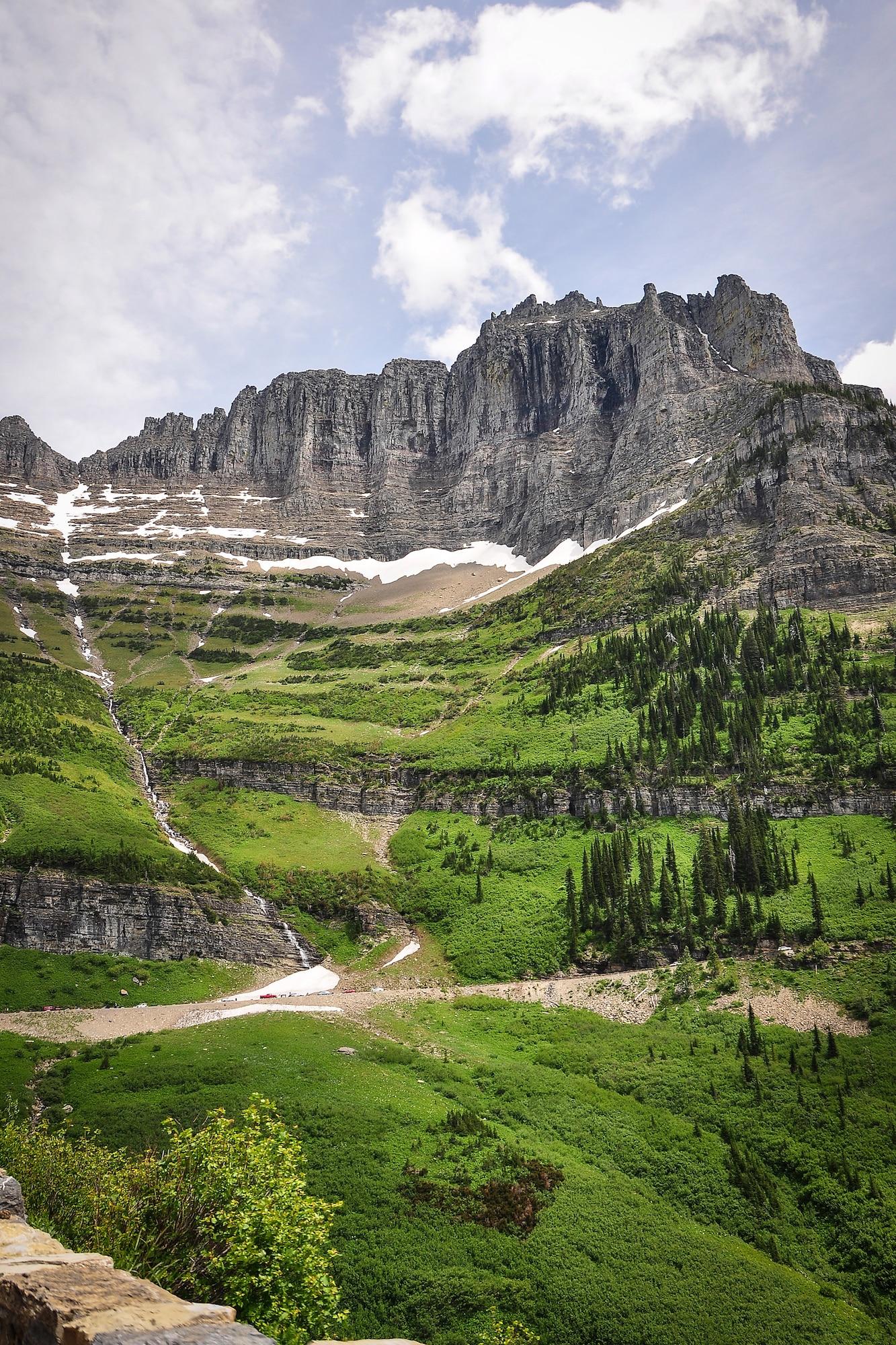
    A Scenic Byway is Born

    In 1989, Beartooth Highway was designated a National Scenic Byways All-American Road, recognizing its extraordinary scenic and recreational qualities. This prestigious designation highlighted its stunning landscapes, which include alpine tundra, glacial lakes, lush forests, and panoramic views of some of the highest peaks in the northern Rockies. The highway, spanning approximately 68 miles, quickly became a must-see destination for travelers seeking a unique and breathtaking driving experience.

    The Infamous 2005 Landslide

    One of the most significant events in the highway's recent history was the devastating landslide in 2005. In May of that year, heavy rains triggered a massive landslide that washed out sections of the highway near the Montana-Wyoming border. The destruction was so severe that it took over a year and millions of dollars to repair the road. The closure had a considerable impact on local tourism and economies, but the community rallied together, and by 2006, the highway was reopened, stronger and more resilient than ever.

    Cultural Significance and Native American Heritage

    Beartooth Highway is not only a marvel of engineering and natural beauty but also a corridor rich in Native American history and culture. The Crow Nation, or Apsáalooke, have lived in the region for centuries and consider the Beartooth Mountains sacred. The area is dotted with ancient trails, campsites, and spiritual sites that reflect the deep connection of the Crow people to the land. Travelers can learn about this heritage through interpretive signs and local museums, gaining a deeper appreciation for the cultural significance of the region.

    Modern Day Adventures and Conservation

    Today, Beartooth Highway is celebrated not just for its historical importance but also for its role in promoting outdoor recreation and conservation. The highway provides access to countless recreational activities, including hiking, fishing, camping, and wildlife viewing. Conservation efforts have been crucial in preserving the pristine environment and ensuring that future generations can enjoy the natural wonders of the Beartooth Mountains. Organizations and volunteers work tirelessly to maintain the highway and its surroundings, balancing the needs of tourism with the imperative to protect the natural landscape.

    Phrasebook

    Local Phrases about Beartooth Highway

    Browse practical local phrases by situation. Each group opens only when needed, keeping the guide tidy while preserving the full phrase set.

    6 phrase groups English + pronunciation
    Basics
    • HelloHowdy
      [Hou-dee]
    • GoodbyeSee ya
      [See yah]
    • YesYup
      [Yuhp]
    • NoNope
      [Nohp]
    • Please/You're welcomePlease n' thank ya
      [Pleez n' thank yah]
    • Thank youMuch obliged
      [Muhch uh-blahjed]
    • Excuse me/SorryPardon me
      [Pahr-dun me]
    • How are you?Howdy
      [Hou-dee]
    • Fine. And you?Just dandy. You?
      [Just dan-dee. Yuh?]
    • Do you speak English?Ya speak English?
      [Yah speak Ing-glish?]
    • I don't understandI reckon I don't get it
      [I wreck-un I don't get it]
    Eating & Drinking
    • I'd like to see the menu, pleaseCan I take a gander at the menu?
      [Can I take a gan-dur at the menu?]
    • I don't eat meatI ain't no meat eater
      [I ain't noh meat ee-ter]
    • Cheers!Bottoms up!
      [Baw-tums up!]
    • I would like to pay, pleaseCan I settle up, please
      [Can I set-ul up, please]
    Emergencies
    • Help!SOS!
      [S-O-S!]
    • Go away!Git!
      [Git!]
    • Call the Police!Ring up the Sheriff!
      [Ring up the Sheriff!]
    • Call a doctor!Call the Doc!
      [Call the Doc!]
    • I'm lostI'm turned around
      [I'm turned a-round]
    • I'm illI'm feelin' poorly
      [I'm feel-in' poor-lee]
    Shopping
    • I'd like to buy...I'm fixin' to purchase...
      [I'm fix-in' to pur-chase...]
    • I'm just lookingJust browsin'
      [Just brow-zin']
    • How much is it?How much for this?
      [How much for this?]
    • That's too expensiveThat's a bit steep
      [That's a bit steep]
    • Can you lower the price?Can ya do any better on the price?
      [Can yah do any bet-ter on the price?]
    Time & Numbers
    • What time is it?What's the hour?
      [What's the hour?]
    • It's one o'clockIt's one in the mornin'
      [It's one in the morn-in']
    • Half past (10)Ten-thirty
      [Ten-thur-tee]
    • MorningMornin'
      [Morn-in']
    • AfternoonAfternoon
      [After-noon]
    • EveningEvenin'
      [Even-in']
    • YesterdayYest'day
      [Yest-day]
    • TodayToday
      [Today]
    • TomorrowTomorrah
      [Tomor-rah]
    • 1One
      [Wun]
    • 2Two
      [Too]
    • 3Three
      [Three]
    • 4Four
      [Fohr]
    • 5Five
      [Fahv]
    • 6Six
      [Siks]
    • 7Seven
      [Sev-en]
    • 8Eight
      [Ayt]
    • 9Nine
      [Nahyn]
    • 10Ten
      [Ten]
    Transport & Directions
    • Where's a/the...?Where's the...
      [Where's the...]
    • What's the address?What's the street?
      [What's the street?]
    • Can you show me (on the map)?Can you point it out (on the map)?
      [Can you point it out (on the map)?]
    • When's the next (bus)?When's the next bus rollin' by?
      [When's the next bus rollin' by?]
    • A ticket (to ....)A ticket (to ...)
      [A ticket (to ...)]

    Explore Beartooth Highway in Photos

    A quick visual tour through classic views, riverside landmarks, royal streets, and skyline moments.

    File:Beartooth Pass -the Pass.jpg - Wikimedia Commons
    File:Beartooth.jpg - Wikimedia Commons
    File:Beartooth Mountains 8.jpg - Wikimedia Commons
    File:Oak Creek Canyon seen from the overlook vista (4106750443).jpg -  Wikimedia Commons
    File:Twin Lakes in Beartooth Mountains.jpg - Wikimedia Commons
    Datei:Pilot and Index Peaks Wyoming.jpg – Wikipedia
    Misawa Airman overcomes homesickness, embraces the local community > Misawa  Air Base > Article Display
    USS Billings Sailors Visit Namesake City > Commander, Naval Surface Force  Atlantic > News Stories

    Planning another trip?

    Continue exploring nearby destinations and classic US city breaks after Beartooth Highway.

    Select Currency

    Choose the currency you want prices to display in.