

Starved Rock State Park Travel Guide - Free Web & App
Your ultimate guide to Starved Rock State Park. Discover top landmarks, proposed trips, and local tips. Free on the web or via the Evendo companion app.


Starved Rock State Park in Illinois offers sandstone canyons, seasonal waterfalls, river bluffs, hiking trails, wildlife and rich regional history.
Sandstone Canyons and River Bluffs
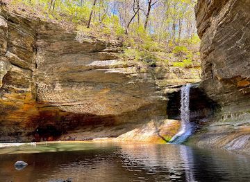
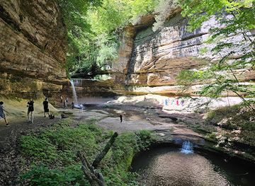
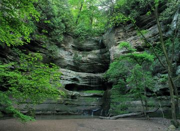
Starved Rock State Park occupies a dramatic section of the Illinois River valley in north-central Illinois, where wooded ravines cut through sandstone bluffs above the river. The park is best known for its box canyons, seasonal waterfalls, forested trails and elevated overlooks, with Starved Rock itself rising prominently beside the water. Eighteen named canyons lie within the park, although access varies according to weather, trail conditions and seasonal water flow. Spring is often the most rewarding period for waterfalls, while autumn brings colour to the deciduous woodland and the river bluffs.Read more about Starved Rock State Park
A Landscape Shaped by Water and Ice
History, Recreation and Visitor Character
When is the best time to visit Starved Rock State Park?
Best: June, August–September · 24–28°C| Month | High (°C) | Rainfall (mm) |
|---|---|---|
| January | 2 | 40 |
| February | 3 | 45 |
| March | 9 | 55 |
| April | 16 | 70 |
| May | 21 | 85 |
| June (best) | 26 | 95 |
| July | 29 | 90 |
| August (best) | 28 | 85 |
| September (best) | 24 | 75 |
| October | 17 | 60 |
| November | 9 | 55 |
| December | 4 | 45 |
Getting to and around Starved Rock State Park
How to get there
Transportation
Best attractions in Starved Rock State Park
Starved Rock State Park's principal attractions are its sandstone bluffs, wooded ravines and eighteen named canyons, reached by trails from the main visitor areas. French Canyon is among the best-known, while St Louis, Wildcat, Ottawa and other ravines reveal the park's layered rock and seasonal streams; waterfalls are most dependable after rain, spring thaw or other suitable wet conditions. Starved Rock itself provides an elevated river landscape and historical associations, while Lover's Leap Overlook and other viewpoints look across the Illinois River and surrounding woodland. The park also offers birdwatching, photography and trails through habitats shaped by the river valley. Starved Rock Lodge, with its historic character and visitor facilities, forms a central focus for many trips. Nearby Matthiessen State Park adds further canyons and waterfalls but is a separate destination, not an attraction within Starved Rock State Park.
-
Visitor center
Starved Rock State Park Visitor Center
Explore the beauty of nature at the Starved Rock State Park Visitor Center, your gateway to Illinois' outdoor adventures and rich cultural heritage.
-
Hotel
Starved Rock Lodge & Conference Center
Discover the beauty and history of Starved Rock Lodge & Conference Center, nestled in the heart of Illinois' breathtaking landscapes.
-
Resort hotel
Grand Bear Resort at Starved Rock
Discover adventure and relaxation at Grand Bear Resort at Starved Rock, where family fun meets nature's beauty in Illinois.
-
State park
Buffalo Rock State Park
Discover the natural beauty and outdoor adventures at Buffalo Rock State Park in Illinois, a serene retreat for nature lovers and adventure seekers.


Best landmarks in Starved Rock State Park
The defining natural landmark is Starved Rock, a sandstone butte above the Illinois River whose name is linked to a debated Indigenous and colonial-era tradition. The surrounding Illinois River bluffs, canyon walls and narrow ravines are the park's principal geological landmarks, with water erosion visible in the layered sandstone and seasonal waterfalls. French Canyon and St Louis Canyon are especially recognisable recesses, while overlooks such as Lover's Leap provide broad views across the river corridor. Starved Rock Lodge is the most prominent historic structure within the park, reflecting the public-park building programme of the 1930s and the work of the Civilian Conservation Corps. Together, the rock, river, canyons and lodge express the area's intertwined natural, cultural and conservation history.
-
State park
Matthiessen State Park
Explore canyons, waterfalls, and unique rock formations at this stunning Illinois state park, a hidden gem near Starved Rock.
-
Visitor center
Starved Rock State Park Visitor Center
Discover the history, geology, and trails of Starved Rock State Park at the visitor center, your gateway to Illinois' natural beauty.
-
Hotel
Starved Rock Lodge & Conference Center
Experience rustic charm and natural beauty at Starved Rock Lodge, nestled in the heart of Starved Rock State Park. A historic Illinois getaway.
-
Resort hotel
Grand Bear Resort at Starved Rock
A family-friendly resort near Starved Rock, featuring an indoor waterpark, comfortable accommodations, and year-round activities in the scenic Illinois Valley.


Explore Starved Rock State Park on the map
Plan your trip on one map. See where the top attractions, landmarks, restaurants and hotels are, and book hotels and experiences in a few clicks.
Best hotels in Starved Rock State Park
Best restaurants in Starved Rock State Park
Dining within Starved Rock State Park is limited compared with an urban destination and centres on Starved Rock Lodge, where visitors may find established hospitality and meals in a historic park setting. For a broader choice, the nearby communities of Utica, Oglesby, Peru and Ottawa provide restaurants, cafés, casual food outlets and provisions for day walks. The Illinois Valley's food culture is shaped by Midwestern agriculture, with familiar American dishes, locally sourced produce when available and the practical traditions of small-town cafés and diners. Visitors planning a full day in the canyons should consider carrying water and suitable food, as trail areas are not lined with refreshment outlets. Farm shops and independent food businesses may be found in the wider countryside, but opening arrangements and seasonal availability vary.
-
Hotel
Starved Rock Lodge & Conference Center
Discover nature's beauty at Starved Rock Lodge & Conference Center - where history meets adventure amidst stunning landscapes.
-
Resort hotel
Grand Bear Resort at Starved Rock
Discover family fun and natural beauty at Grand Bear Resort near Starved Rock State Park - your ultimate getaway destination!
-
Grill
Jamie's OutPost
Discover delicious grilled cuisine and unique souvenirs at Jamie's OutPost in North Utica - your perfect stop on the way to Starved Rock.
-
Grill
Skoog's Pub & Grill
Experience delicious American cuisine at Skoog's Pub & Grill in North Utica – where great food meets warm hospitality.


Best bars in Starved Rock State Park
Starved Rock State Park is an outdoor destination rather than a nightlife centre. Evening activity is concentrated around the lodge, accommodation areas and the quiet hospitality of nearby gateway communities, where visitors may find traditional bars, restaurants and small-town social venues rather than clubs or a dedicated entertainment district. Utica, Oglesby, Peru and Ottawa offer the widest choice outside the park, although venue types and opening patterns vary. After dark, the park itself is better suited to the calm atmosphere of a wooded river landscape than to organised entertainment; visitors should follow current park rules and avoid entering closed trails or canyon areas at night. Seasonal events and occasional community activities may add variety, but should be checked locally rather than assumed.
-
State park
Starved Rock State Park
Discover the breathtaking canyons, waterfalls, and diverse wildlife of Starved Rock State Park, a true natural wonder in Illinois.
-
Hotel
Starved Rock Lodge & Conference Center
Discover the enchanting Starved Rock Lodge & Conference Center, where nature meets comfort in the heart of Illinois' stunning landscapes.
-
Resort hotel
Grand Bear Resort at Starved Rock
Discover a family-friendly paradise at Grand Bear Resort, featuring a water park, dining, and easy access to the natural beauty of Starved Rock State Park.
-
Grill
Skoog's Pub & Grill
Experience the taste of America at Skoog's Pub & Grill, where hearty dishes and a warm atmosphere await in North Utica.


Best nightclubs in Starved Rock State Park
Starved Rock State Park is an outdoor destination rather than a nightlife centre. Evening activity is concentrated around the lodge, accommodation areas and the quiet hospitality of nearby gateway communities, where visitors may find traditional bars, restaurants and small-town social venues rather than clubs or a dedicated entertainment district. Utica, Oglesby, Peru and Ottawa offer the widest choice outside the park, although venue types and opening patterns vary. After dark, the park itself is better suited to the calm atmosphere of a wooded river landscape than to organised entertainment; visitors should follow current park rules and avoid entering closed trails or canyon areas at night. Seasonal events and occasional community activities may add variety, but should be checked locally rather than assumed.
-
Resort hotel
Grand Bear Resort at Starved Rock
Experience family fun and adventure at Grand Bear Resort in North Utica, Illinois, near the picturesque Starved Rock State Park.
-
Grill
Captain's Cove Bar & Grill At Starved Rock Marina
Experience the perfect blend of delightful cuisine and breathtaking views at Captain's Cove Bar & Grill, a must-visit gem near Starved Rock Marina.
-
Escape room center
Starved Rock Entertainment
Experience thrilling escape rooms and fun-filled activities at Starved Rock Entertainment, perfect for families and friends in North Utica, Illinois.
-
Yacht club
Starved Rock Yacht Club
Discover the tranquility of Starved Rock Yacht Club, where boating meets community in a stunning riverside setting.


Best shops in Starved Rock State Park
Shopping at Starved Rock is modest and primarily connected with visitor needs, park souvenirs and the hospitality facilities around Starved Rock Lodge rather than a large retail district. Utica, Oglesby, Peru and Ottawa offer more practical shopping, including groceries, outdoor supplies, cafés and independent businesses useful for preparing for a day on the trails. The wider Illinois Valley has agricultural producers, farm shops and locally made goods, although these are distributed across the countryside rather than gathered in one permanent market. Regional purchases may include food products, artwork and craft items associated with northern Illinois, but particular stock and seasonal markets vary. Visitors should obtain specialist hiking equipment, medication and substantial provisions in a nearby town rather than expecting the park itself to function as a full shopping centre.
-
State park
Starved Rock State Park
Discover the breathtaking beauty of Starved Rock State Park, a natural wonderland of canyons, waterfalls, and diverse wildlife in Illinois.
-
Coffee shop
Bruce & Ollie's Ice Cream, Specialty Coffee & Deli
Experience the ultimate treat at Bruce & Ollie's Ice Cream, Specialty Coffee & Deli in North Utica, IL, where flavors and hospitality blend seamlessly.
-
Bait shop
Starved Rock River and Trail Supply
Discover outdoor adventures at Starved Rock River and Trail Supply, your one-stop shop for fishing gear and local expertise near Starved Rock State Park.


Get your free copy of our complete guide to Starved Rock State Park, delivered straight to you.
Everything on this page, from attractions and restaurants to essentials and local phrases, in one PDF you can read offline, print or share.
Already have an account? Sign in
Your Starved Rock State Park guide is ready.
We'll send it to · Not you? Sign out

Getting your guide ready…
We are putting together a fresh copy of the Starved Rock State Park guide. This can take up to a minute.
This can take a few moments. If your browser asks, choose Allow so the download can start. You'll find the guide in your Downloads folder.
Nothing happened? Download it again
Sorry, the guide is taking longer than usual. Please try again in a minute, or get it by email instead.
Starved Rock State Park essentials
Currency and Payment
Safety
Emergency Situations
Do's and Don'ts
Local Tips
From Eve
Local phrases worth knowing
You don't need to get them perfect. A few words go a long way, and locals appreciate the effort.
Basics
| English | Local | Say it |
|---|---|---|
| Hello | Ay-up | [ay-uhp] |
| Goodbye | Ta-ra | [tah-rah] |
| Yes | Aye | [ai] |
| No | Nay | [nay] |
| Please/You're welcome | Please/Tha'rt welcome | [pliz/tha-rt wel-kum] |
| Thank you | Cheers | [cheers] |
| Excuse me/Sorry | Pardon me | [par-dn mee] |
| How are you? | How's tha? | [hows thah] |
| Fine. And you? | Reight. An' thi? | [rayt. an thee] |
| Do you speak English? | Dost tha speak English? | [dost thah speak ing-glish] |
| I don't understand | Ah divvent understand | [ah div-ent un-der-stan] |
Eating & Drinking
| English | Local | Say it |
|---|---|---|
| I'd like to see the menu, please | Ah'd like t'see t'menu, please | [ahd like t see t menu, pliz] |
| I don't eat meat | Ah divvent eat meat | [ah div-ent eet meet] |
| Cheers! | Skol! | [skol] |
| I would like to pay, please | Ah'd like t'pay, please | [ahd like t pay, pliz] |
Emergencies
| English | Local | Say it |
|---|---|---|
| Help! | He'p! | [hep] |
| Go away! | Clear off! | [clayr off] |
| Call the Police! | Ring t'cops! | [ring t cops] |
| Call a doctor! | Ring t'doc! | [ring t dock] |
| I'm lost | Ah'm lost | [ahm lost] |
| I'm ill | Ah'm poorly | [ahm paw-lee] |
Shopping
| English | Local | Say it |
|---|---|---|
| I'd like to buy... | Ah'd like t'buy... | [ahd like t buy] |
| I'm just looking | Ah'm just lookin' | [ahm just look-in] |
| How much is it? | Ow much is it? | [ow much is it] |
| That's too expensive | That's reet dear | [thats rayt deer] |
| Can you lower the price? | Can tha drop t'price? | [can thah drop t price] |
Time & Numbers
| English | Local | Say it |
|---|---|---|
| What time is it? | What's time? | [whats time] |
| It's one o'clock | It's one o'clock | [its one o'clock] |
| Half past (10) | Ha' past ten | [haff past ten] |
| Morning | Mornin' | [morn-in] |
| Afternoon | Afternoon | [aft-er-noon] |
| Evening | Evenin' | [ev-en-in] |
| Yesterday | Yest'day | [yest-day] |
| Today | Today | [to-day] |
| Tomorrow | T'morra | [t mor-ra] |
| 1 | One | [wun] |
| 2 | Two | [too] |
| 3 | Three | [three] |
| 4 | Four | [for] |
| 5 | Five | [fiv] |
| 6 | Six | [siks] |
| 7 | Seven | [sev-en] |
| 8 | Eight | [ayt] |
| 9 | Nine | [nine] |
| 10 | Ten | [ten] |
Transport & Directions
| English | Local | Say it |
|---|---|---|
| Where's a/the...? | Where's a/the...? | [wheres a/the] |
| What's the address? | What's t'address? | [whats t address] |
| Can you show me (on the map)? | Can tha show me (on t'map)? | [can thah show me (on t map)] |
| When's the next (bus)? | When's t'next (bus)? | [whens t next (bus)] |
| A ticket (to ....) | A ticket (to ....) | [a ticket (to)] |
History of Starved Rock State Park
Glacial Waters and Sandstone Formation
Starved Rock's physical character was shaped long before human settlement. During the late Ice Age, meltwater flowing through the Illinois River valley cut into sandstone and helped create the bluffs, ravines and narrow canyons visible today. Later streams continued to erode the softer rock, producing the park's characteristic recesses and seasonal waterfalls. The river corridor also became an important route for wildlife and people, linking the interior of Illinois with the wider Mississippi basin.
The Illiniwek and River Valley Peoples
The Illinois River valley was inhabited and used by Indigenous peoples for centuries before European arrival. The name Starved Rock is connected to an oral tradition involving a conflict and siege affecting members of the Illiniwek and Ottawa peoples. Several versions of the story exist, and historians have questioned aspects of the traditional narrative, so the legend is best understood as part of the area's layered cultural memory rather than as a completely documented account. Indigenous presence remains central to understanding the significance of the landscape.
French Exploration and Fort St Louis
In the seventeenth century, French explorers and missionaries travelled along the Illinois River, including Louis Jolliet and Jacques Marquette during their 1673 journey through the region. René-Robert Cavelier, Sieur de La Salle, later established Fort St Louis on or near the prominent rock in the early 1680s. The settlement formed part of France's effort to strengthen its influence in the interior, although the fort was later abandoned. Archaeological interpretation and historical research continue to inform understanding of this period.
Settlement, Industry and a Changing River
After the region passed into American control, agricultural settlement and transport altered the Illinois River corridor. Nearby communities such as Utica and Ottawa developed as local centres, while the river supported commerce and movement through the interior. The surrounding landscape was gradually modified by farming, roads, quarrying and other development, increasing the value placed on the remaining bluffs, ravines and woodland. These changes helped establish the argument for preserving the area as a public recreational landscape.
A State Park and Conservation Landscape
Illinois acquired Starved Rock as a state park in 1911, beginning its modern life as a public destination. Visitor facilities expanded during the twentieth century, including Starved Rock Lodge and cabins constructed in the 1930s with important assistance from the Civilian Conservation Corps. The lodge's use of local materials reflects the era's park architecture. Conservation management now balances heavy recreational use with the protection of sandstone formations, woodland, river habitats and sensitive canyon environments.
Starved Rock State Park in Photos
Browse through our photo collection highlighting the charm and character of the destination.
Neighbouring destination travel guides
The closest destinations to Starved Rock State Park, if you have time for more than one.
-

-

-

-
-


Swipe for more destinations
Explore more
Explore more of Illinois River Valley
Explore the Illinois River Valley for Starved Rock bluffs, riverfront museums, wetland wildlife, historic towns and central Illinois landscapes.
Explore Illinois River Valley
Explore more of Illinois
Discover Illinois: From Chicago's iconic skyline to the tranquil beauty of its countryside, experience the diverse allure of the Prairie State.
Explore Illinois