

Free San Ramon Travel Guide & Mobile App
Plan your San Ramon trip with Evendo. Get free guides to top attractions, restaurants, hotels, and bars. Web access or download the mobile app.


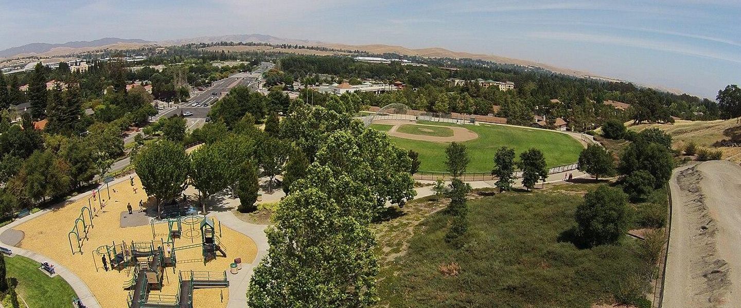


San Ramon, California, pairs East Bay trails and open space with historic farms, modern architecture, family attractions and easy access to Bay Area culture.
A Valley City in the East Bay
San Ramon lies in the inland East Bay, between the wooded ridgelines of Mount Diablo State Park and the settled communities of the Livermore-Amador Valley. Once a rural agricultural area, it is now a carefully planned Californian city known for broad boulevards, landscaped business campuses, family neighbourhoods and extensive open space. Its position places Bay Area culture within reach while giving the city a quieter, spacious character of its own.Read more about San Ramon
From Ranchland to Contemporary City
Open Space and Everyday Exploration
When is the best time to visit San Ramon?
Best: May–June, September · 23–28°C| Month | High (°C) | Rainfall (mm) |
|---|---|---|
| January | 14 | 109 |
| February | 16 | 99 |
| March | 17 | 81 |
| April | 20 | 37 |
| May (best) | 23 | 17 |
| June (best) | 26 | 5 |
| July | 29 | 2 |
| August | 29 | 2 |
| September (best) | 28 | 5 |
| October | 24 | 37 |
| November | 17 | 66 |
| December | 13 | 97 |
Getting to and around San Ramon
How to get there
Transportation
Best attractions in San Ramon
San Ramon's attractions are spread across parks, trails, heritage sites and contemporary public spaces rather than concentrated in an old town. Forest Home Farms offers a window onto the valley's agricultural past through historic farm buildings, orchards and open grounds. The Iron Horse Regional Trail, created along a former railway corridor, is a popular route for walking, cycling and observing the settled valley from a quieter vantage point. Memorial Park and Central Park provide broad lawns, sports areas and family-friendly recreation, while the Dougherty Station Community Center adds indoor cultural and community facilities. At City Center Bishop Ranch, landscaped plazas, public art, shops, restaurants and entertainment create a modern urban focus. The western and southern edges of the city also provide access to trails leading towards Las Trampas Regional Wilderness and the Diablo foothills, where grassland, oak woodland and ridge views replace the built-up landscape. Together, these places show San Ramon as a city shaped as much by open space and planning as by conventional sightseeing.
-
Tourist attraction
Central Park
San Ramon's Central Park: A vibrant community hub with recreation, events, and natural beauty for all ages to enjoy.
11 min drive · 3.5 km from city centre
-
Tourist attraction
Las Trampas Regional Wilderness Park
Experience the natural beauty and outdoor adventures at Las Trampas Regional Wilderness Park, a perfect retreat for nature lovers in California.
19 min drive · 6.3 km from city centre
-
Tourist attraction
Rancho San Ramon Community Park
Experience the beauty of nature at Rancho San Ramon Community Park, a perfect escape for families and outdoor enthusiasts in San Ramon, California.
21 min drive · 7.0 km from city centre
-
Tourist attraction
San Ramon Athan Downs
Explore the lush landscapes and vibrant recreational facilities of San Ramon Athan Downs, a perfect getaway for families and nature lovers alike.
13 min drive · 4.2 km from city centre


Best landmarks in San Ramon
San Ramon's landmarks express different layers of the city's history and planning. Forest Home Farms is the clearest material reminder of the agricultural valley, with historic farm structures and cultivated land preserving the setting in which rural San Ramon developed. The Iron Horse Regional Trail is a landmark of another kind: its route follows the former railway corridor that helped connect East Bay communities before being reimagined as a public pathway. Bishop Ranch and City Center Bishop Ranch represent the city's transformation into a major commercial and mixed-use centre, with contemporary architecture, landscaped plazas and civic-scale public spaces. San Ramon City Hall and the Dougherty Station Community Center reflect the civic infrastructure of the incorporated city, while Memorial Park serves as a familiar recreational focal point for residents. None is a medieval monument or grand historic square; together they tell a more Californian story of ranchland, transport, planned growth and modern public life.
-
Shopping mall
Diablo Plaza
Experience premier shopping and dining at Diablo Plaza in San Ramon, a vibrant community hub with diverse stores, eateries, and year-round events, easily accessible near Bishop Ranch and I-680.
18 min walk · 1.5 km from city centre
-
Museum
Blackhawk Museum
Discover a world-class collection of classic cars, art, and cultural artifacts at the Blackhawk Museum in Danville, offering a unique and educational experience for all ages.
22 min drive · 7.4 km from city centre
-
Park
Las Trampas Regional Wilderness Park
Explore the stunning landscapes and diverse wildlife at Las Trampas Regional Wilderness Park, a perfect spot for hiking, picnicking, and outdoor adventures in California.
19 min drive · 6.3 km from city centre
-
Shopping mall
Shops At Bishop Ranch
Discover a vibrant open-air destination in San Ramon with upscale shopping, diverse dining, entertainment, and community events at the architecturally stunning Shops at Bishop Ranch.
9 min drive · 3.1 km from city centre


Explore San Ramon on the map
Plan your San Ramon trip on one map. See where the top attractions, landmarks, restaurants, bars and hotels are, find what's near where you're staying, and book hotels and experiences in a few clicks.
Best hotels in San Ramon
Best restaurants in San Ramon
San Ramon's dining scene reflects its suburban growth and highly international East Bay population. Restaurants range across American cooking, Californian produce-led menus, Mexican food, South and East Asian cuisines, Mediterranean dishes, cafés and familiar fast-casual formats. City Center Bishop Ranch provides a polished concentration of restaurants and outdoor dining, while commercial corridors and neighbourhood shopping centres offer a broader mix of independent and chain establishments. The area is also influenced by the culinary traditions of the wider Bay Area, where farm produce, coffee culture and immigrant-owned restaurants sit comfortably alongside contemporary dining. Visitors should expect a dispersed scene rather than a single historic restaurant quarter; local dining is often combined with shopping, cinema or an evening at a community venue. Farmers' markets and seasonal produce connect the modern food culture with the valley's older agricultural identity, although market locations and schedules vary.
-
Hamburger
In-N-Out Burger
Discover In-N-Out Burger in San Ramon: iconic burgers crafted with fresh ingredients in a nostalgic diner setting.
5 min drive · 1.6 km from city centre
-
Brewpub
Fieldwork Brewing Company - San Ramon
Experience the best of craft brewing at Fieldwork Brewing Company in San Ramon—where innovative flavors meet vibrant community vibes.
10 min drive · 3.2 km from city centre
-
Cajun
Clementine's
Experience authentic Cajun cuisine at Clementine's in San Ramon—where every meal is a celebration of flavor and southern hospitality.
9 min drive · 2.9 km from city centre
-
Lebanese
Shish Grill
Discover authentic Lebanese cuisine at Shish Grill in San Ramon - where every bite tells a story of Mediterranean heritage.
11 min drive · 3.8 km from city centre


Best bars in San Ramon
San Ramon's evening scene is relatively low-key and suburban, centred more on restaurants, wine and cocktail service, cafés, cinema and occasional live or community programming than on a dense nightclub district. City Center Bishop Ranch provides the most concentrated contemporary setting after dark, with public spaces and dining venues that remain active into the evening. Additional bars can be found within restaurant areas and commercial centres, but nightlife is generally dispersed and tends to suit conversation, dinner or a relaxed drink rather than late-night clubbing. For larger concert, theatre and nightlife choices, visitors often travel to Walnut Creek, Oakland, Berkeley or San Francisco, depending on the event and transport available. Alcohol service follows California law, and venues may require government-issued photo identification. The area's business-campus character also means that evening activity can be noticeably quieter away from the principal commercial centres.
-
Brewpub
Fieldwork Brewing Company - San Ramon
Discover the vibrant atmosphere and diverse selection of craft beers at Fieldwork Brewing Company, a must-visit brewpub in San Ramon, CA.
10 min drive · 3.2 km from city centre
-
Bar
Clementine's
Discover the vibrant flavors of Cajun cuisine at Clementine's, a cozy bar and restaurant in San Ramon offering delicious breakfast and Southern specialties.
9 min drive · 2.9 km from city centre
-
Lebanese
Shish Grill
Savor the authentic taste of Lebanese cuisine at Shish Grill, a must-visit restaurant in San Ramon for Mediterranean food lovers.
11 min drive · 3.8 km from city centre
-
Bar
Brass Door
Experience the finest American cuisine and vibrant sports bar atmosphere at Brass Door in San Ramon, a culinary destination for every palate.
5 min drive · 1.7 km from city centre


Best nightclubs in San Ramon
San Ramon's evening scene is relatively low-key and suburban, centred more on restaurants, wine and cocktail service, cafés, cinema and occasional live or community programming than on a dense nightclub district. City Center Bishop Ranch provides the most concentrated contemporary setting after dark, with public spaces and dining venues that remain active into the evening. Additional bars can be found within restaurant areas and commercial centres, but nightlife is generally dispersed and tends to suit conversation, dinner or a relaxed drink rather than late-night clubbing. For larger concert, theatre and nightlife choices, visitors often travel to Walnut Creek, Oakland, Berkeley or San Francisco, depending on the event and transport available. Alcohol service follows California law, and venues may require government-issued photo identification. The area's business-campus character also means that evening activity can be noticeably quieter away from the principal commercial centres.
-
Pool hall
Crown Billiards
Discover Crown Billiards in San Ramon, CA - the ultimate pool hall for friendly competition and social fun in a lively atmosphere.
5 min drive · 1.6 km from city centre
-
Indian
Curry Up Now
Discover the vibrant flavors of India at Curry Up Now in San Ramon, where modern dining meets traditional cuisine and vegan delights await.
10 min drive · 3.2 km from city centre
-
Bar
Auburn Lounge
Experience the vibrant atmosphere of Auburn Lounge in Danville, where live music, exquisite wines, and great company await every visitor.
17 min drive · 5.5 km from city centre
-
Bar
Gaucho Brazilian Steakhouse n Nightclub
Experience authentic Brazilian flavors and vibrant nightlife at Gaucho Brazilian Steakhouse & Nightclub in San Ramon, CA.
5 min drive · 1.6 km from city centre


Best shops in San Ramon
Shopping in San Ramon is organised around contemporary mixed-use developments, commercial centres and neighbourhood plazas rather than a traditional market street. City Center Bishop Ranch is the most prominent destination for a combination of retail, restaurants, public events and modern architecture, while other shopping areas provide everyday services, specialist stores and cafés. Visitors looking for local character can pair retail browsing with Forest Home Farms or a walk along the Iron Horse Regional Trail, although San Ramon is not primarily a craft-market or antique-shopping destination. The wider East Bay adds independent boutiques, specialist food shops and farmers' markets within a short drive. Californian food products, coffee, wine from the broader Bay Area and practical outdoor equipment are more representative purchases than a single signature San Ramon handicraft. Opening patterns and market schedules vary, so shopping is best treated as part of a wider neighbourhood outing.
-
Shopping mall
Diablo Plaza
Discover Diablo Plaza in San Ramon: a vibrant shopping destination with diverse stores, delightful eateries, and fresh grocery options for every traveler.
18 min walk · 1.5 km from city centre
-
Shopping mall
Shops At Bishop Ranch
Discover a diverse shopping and dining experience at the Shops at Bishop Ranch, a premier destination in San Ramon, California.
9 min drive · 3.1 km from city centre
-
Shopping mall
Crow Canyon Commons
Discover Crow Canyon Commons in San Ramon for a vibrant shopping experience, delightful dining, and community events that capture local culture.
6 min drive · 2.1 km from city centre
-
Sporting goods store
Sports Basement San Ramon
Discover your outdoor adventure at Sports Basement San Ramon, the ultimate destination for sporting goods, bicycle rentals, and outdoor gear in California.
11 min drive · 3.8 km from city centre


Get your free copy of our complete guide to San Ramon, delivered straight to you.
Everything on this page, from attractions and restaurants to essentials and local phrases, in one PDF you can read offline, print or share.
Already have an account? Sign in
Your San Ramon guide is ready.
We'll send it to · Not you? Sign out

Getting your guide ready…
We are putting together a fresh copy of the San Ramon guide. This can take up to a minute.
This can take a few moments. If your browser asks, choose Allow so the download can start. You'll find the guide in your Downloads folder.
Nothing happened? Download it again
Sorry, the guide is taking longer than usual. Please try again in a minute, or get it by email instead.
San Ramon essentials
Currency and Payment
Safety
Emergency Situations
Do's and Don'ts
Local Tips
From Eve
Local phrases worth knowing
You don't need to get them perfect. A few words go a long way, and locals appreciate the effort.
Basics
| English | Local | Say it |
|---|---|---|
| Hello | Howdy | [haw-dee] |
| Goodbye | See ya | [see yah] |
| Yes | Yep | [yep] |
| No | Nope | [nope] |
| Please/You're welcome | Please | [pleez] |
| Thank you | Thanks | [thanks] |
| Excuse me/Sorry | Excuse me | [ex-kyooz mee] |
| How are you? | How's it goin'? | [hows it go-in] |
| Fine. And you? | Fine. You? | [fine. yoo] |
| Do you speak English? | You speak English? | [yoo speek ing-glish] |
| I don't understand | I don't get it | [eye don't get it] |
Eating & Drinking
| English | Local | Say it |
|---|---|---|
| I'd like to see the menu, please | Can I see the menu? | [kan eye see the menu] |
| I don't eat meat | I'm vegetarian | [im ve-juh-tair-ee-an] |
| Cheers! | Cheers! | [cheers] |
| I would like to pay, please | Check, please | [chek, please] |
Emergencies
| English | Local | Say it |
|---|---|---|
| Help! | Help! | [help] |
| Go away! | Get lost! | [get lost] |
| Call the Police! | Call the cops! | [call the cops] |
| Call a doctor! | Get a doc! | [get a doc] |
| I'm lost | I'm lost | [eye'm lost] |
| I'm ill | I'm sick | [eye'm sik] |
Shopping
| English | Local | Say it |
|---|---|---|
| I'd like to buy... | I wanna buy... | [eye wanna buy] |
| I'm just looking | Just browsing | [just brows-ing] |
| How much is it? | How much? | [how much] |
| That's too expensive | Too pricey | [too pry-see] |
| Can you lower the price? | Can you do better? | [kan yoo do bet-ter] |
Time & Numbers
| English | Local | Say it |
|---|---|---|
| What time is it? | What's the time? | [whats the time] |
| It's one o'clock | It's one | [its one] |
| Half past (10) | Half ten | [half ten] |
| Morning | Morning | [morning] |
| Afternoon | Afternoon | [afternoon] |
| Evening | Evening | [evening] |
| Yesterday | Yesterday | [yester-day] |
| Today | Today | [to-day] |
| Tomorrow | Tomorrow | [tomor-row] |
| 1 | One | [wun] |
| 2 | Two | [too] |
| 3 | Three | [three] |
| 4 | Four | [four] |
| 5 | Five | [five] |
| 6 | Six | [six] |
| 7 | Seven | [seven] |
| 8 | Eight | [eight] |
| 9 | Nine | [nine] |
| 10 | Ten | [ten] |
Transport & Directions
| English | Local | Say it |
|---|---|---|
| Where's a/the...? | Where's the...? | [wheres the] |
| What's the address? | What's the address? | [whats the address] |
| Can you show me (on the map)? | Can you show me? | [kan yoo show me] |
| When's the next (bus)? | When's the next one? | [whens the next one] |
| A ticket (to ....) | One ticket (to ...) | [wun ticket (to)] |
History of San Ramon
Ohlone Communities of the Valley
Before European settlement, the San Ramon Valley was inhabited by Ohlone peoples whose communities depended on the region's grasslands, oak woodland, seasonal waterways and native food sources. The valley formed part of a wider network of Indigenous territories rather than a single urban settlement. Spanish colonisation, mission expansion and the diseases and disruptions that followed profoundly altered Indigenous life during the late eighteenth and early nineteenth centuries. Although little of the original settlement pattern remains visible to visitors, the valley's ecology and place names exist within this deeper history, which predates the later ranches and suburban development associated with San Ramon.
Mission Frontier and Mexican Ranchos
Spanish and then Mexican authority reshaped the valley through mission influence, cattle ranching and land grants. After Mexican independence, José María Amador received Rancho San Ramon in 1833, a large rancho that helped give the area its enduring name. The rancho economy relied on livestock, open grazing and the valley's access to routes linking the inland settlements with the broader Bay Area. Following the United States' annexation of California in 1848, land ownership and administration changed again. The rancho landscape gradually fragmented into farms, roads and smaller settlements, laying the foundations for the rural community that developed during the nineteenth century.
Farms, Roads and Rural Settlement
During the second half of the nineteenth century, San Ramon developed as an agricultural settlement rather than a major town. Grain, cattle, orchards and other farm activities shaped the valley, while roads and later railway connections improved the movement of produce and people. Family farms and ranch buildings spread across land that had once formed part of the rancho. The community's relationship with nearby Danville, which became an important local centre, remained close. Sites such as Forest Home Farms preserve elements of this period, when the low-density landscape was defined by fields, mature trees, farm lanes and practical wooden buildings.
A Quiet Agricultural Community
For much of the twentieth century, San Ramon retained its rural character even as the surrounding East Bay became more urbanised. Improved roads brought commuters and gradual residential growth, but orchards, ranchland and open hills still dominated the valley. The former Southern Pacific railway corridor later became the Iron Horse Regional Trail, preserving a significant transportation route as a recreational connection. This transition from rail infrastructure to public trail reflects the area's broader evolution: agricultural land and transport networks were not simply erased, but adapted as the community changed.
Incorporation and Planned Growth
San Ramon incorporated as a city in 1983, after decades of growth had begun to transform the unincorporated valley. The late twentieth and early twenty-first centuries brought large-scale residential development, corporate campuses and new civic facilities, especially around Bishop Ranch. Planning shaped the city through separated land uses, landscaped roads, parks and extensive pathways rather than a traditional compact downtown. Modern San Ramon therefore exists as a layered landscape: Indigenous and ranching histories survive in place names, farms and open space, while business districts, community centres and public-realm projects express the city's contemporary identity.
San Ramon in Photos
Browse through our photo collection highlighting the charm and character of the destination.
Cities near San Ramon
The closest cities to San Ramon, if you have time for more than one stop.
-

-
-

-

-


Swipe for more cities
Explore more
Explore more of California
Discover California: A land of diverse landscapes, iconic cities, and endless adventures, from sun-soaked beaches to towering redwoods and vibrant cultural experiences.
Explore California