

Free Sequoia National Park Travel Guide & Mobile App
Plan your Sequoia National Park trip with Evendo. Get free guides to top attractions, restaurants, hotels, and bars. Web access or download the mobile app.


Sequoia National Park in California pairs giant trees, granite peaks and deep canyons with memorable hiking, wildlife and high-country scenery.
Among the Giant Sequoias
Sequoia National Park occupies the southern Sierra Nevada of California, rising from warm foothills into a mountain landscape of enormous trees, granite walls and alpine ridges. Its defining sight is the giant sequoia, a species found naturally only in scattered groves along the western Sierra Nevada. In the Giant Forest, the General Sherman Tree stands among some of the largest living organisms on Earth, while trails lead beneath immense trunks, through fern-edged woodland and towards open viewpoints. The park's character changes with elevation: oak-studded foothills give way to conifer forest, meadows and rugged high country.Read more about Sequoia National Park
Mountains, Canyons and Quiet Roads
When is the best time to visit Sequoia National Park?
Best: June, August–September · 26–30°C| Month | High (°C) | Rainfall (mm) |
|---|---|---|
| January | 7 | 90 |
| February | 8 | 80 |
| March | 11 | 70 |
| April | 15 | 50 |
| May | 21 | 30 |
| June (best) | 26 | 20 |
| July | 30 | 20 |
| August (best) | 30 | 20 |
| September (best) | 26 | 30 |
| October | 19 | 50 |
| November | 12 | 70 |
| December | 7 | 80 |
Getting to and around Sequoia National Park
How to get there
Transportation
Best attractions in Sequoia National Park
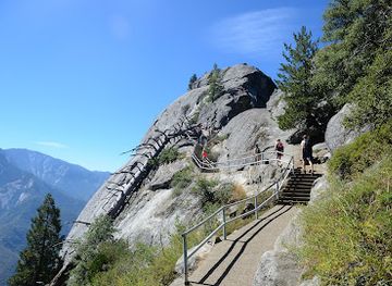
Sequoia National Park's principal attractions are landscapes rather than urban sights. The Giant Forest contains dense stands of giant sequoias and the General Sherman Tree, reached by a marked route through towering woodland. Nearby Moro Rock rises dramatically above the forest; its stone stairway leads to extensive views across the Great Western Divide and the foothills. Crescent Meadow offers a quieter setting of open grassland and conifers, with trails continuing towards historic mountain cabins and viewpoints. The Giant Forest Museum explains the biology and conservation of the sequoias, while Tunnel Rock provides a brief roadside stop below a notable granite formation. Longer trails lead towards alpine lakes, high passes and the canyon country shared with Kings Canyon National Park, although distances, elevation and seasonal conditions make these more demanding outings than the developed grove walks.
-
Tourist attraction
General Sherman Tree
Explore the awe-inspiring General Sherman Tree, the largest tree on earth, nestled in Sequoia National Park's breathtaking landscapes.
40 min drive · 20 km from city centre
-
Tourist attraction
General Sherman Tree
Discover the awe-inspiring General Sherman Tree in Sequoia National Park, a natural wonder that showcases the beauty and majesty of the world's largest tree.
40 min drive · 20 km from city centre
-
Tourist attraction
Moro Rock Trail
Explore the breathtaking Moro Rock Trail in Sequoia National Park, where stunning views and nature await every adventurer.
39 min drive · 19 km from city centre
-
Visitor center
Kings Canyon Visitor Center
Your adventure starts here! Maps, exhibits, permits & expert advice await at the gateway to Sequoia & Kings Canyon National Parks.
1 h 5 min drive · 45 km from city centre


Best landmarks in Sequoia National Park
The General Sherman Tree is Sequoia National Park's foremost living landmark, valued for its immense volume and age rather than exceptional height. Its grove forms part of the Giant Forest, a landscape central to the park's identity and conservation history. Moro Rock is a prominent granite dome and a significant built landmark as well as a natural one, with a carved stairway leading across exposed rock to a high viewpoint. Tunnel Rock, shaped to allow an early road through its mass, records the history of automobile access into the mountains. The Giant Forest Museum represents the park's educational tradition, interpreting sequoia ecology and changing ideas about preservation. Historic cabins and meadow structures around Crescent Meadow add a human layer to the landscape, linking early recreation with the continuing protection of the Sierra environment.
-
Tourist attraction
General Sherman Tree
Experience the awe-inspiring presence of the General Sherman Tree, the world's largest tree, in Sequoia National Park's Giant Forest, a testament to nature's enduring majesty and ancient history.
40 min drive · 20 km from city centre
-
Hiking area
Moro Rock Trail
Ascend Moro Rock's historic stairway for unparalleled panoramic views of Sequoia National Park, offering a thrilling and unforgettable experience amidst the Sierra Nevada's grandeur.
39 min drive · 19 km from city centre
-
Park
Sequoia & Kings Canyon National Parks
Discover the awe-inspiring beauty of Sequoia & Kings Canyon National Parks: home to the world's largest trees and deepest canyons, offering unforgettable adventures in California's Sierra Nevada.
43 min drive · 23 km from city centre
-
Visitor center
Kings Canyon Visitor Center
Discover the majesty of Kings Canyon National Park at the visitor center, your gateway to giant sequoias, deep canyons, and the High Sierra, offering maps, permits, and expert advice.
1 h 5 min drive · 45 km from city centre



Explore Sequoia National Park on the map
Plan your Sequoia National Park trip on one map. See where the top attractions, landmarks, restaurants, bars and hotels are, find what's near where you're staying, and book hotels and experiences in a few clicks.
Best hotels in Sequoia National Park
Best restaurants in Sequoia National Park
Dining within Sequoia National Park is limited and centred on seasonal lodges, camp facilities and visitor services rather than a town-like restaurant scene. Travellers commonly arrange meals before entering the mountains, especially when planning long days on remote trails. Three Rivers, near the southern entrance, provides the nearest concentration of cafés, restaurants and provisions, while larger towns such as Visalia offer broader choice before the mountain drive. Picnic meals are a practical part of the park experience, but food must be handled and stored carefully because bears and other wildlife are attracted to unattended supplies. The local food culture reflects California's Central Valley and Sierra foothills, with seasonal produce, American comfort food and packed provisions more characteristic than a distinct park cuisine.
-
Hiking area
Moro Rock Trail
Explore Moro Rock Trail: A breathtaking hiking experience in Sequoia National Park offering stunning views of California's Sierra Nevada mountains.
39 min drive · 19 km from city centre
-
Museum
Giant Forest Museum
Explore nature's giants at Giant Forest Museum in Sequoia National Park - a captivating blend of education and breathtaking scenery.
40 min drive · 20 km from city centre
-
Restaurant
The Gateway Restaurant & Lodge
Discover the perfect blend of fine dining and cozy lodging at The Gateway Restaurant & Lodge near Sequoia National Park.
44 min drive · 24 km from city centre
-
American
River View Grill & Bar
Discover River View Grill & Bar in Three Rivers: A perfect blend of scenic views and delectable American cuisine awaits you!
50 min drive · 30 km from city centre


Best bars in Sequoia National Park
Sequoia National Park has no conventional nightlife district, and evenings are shaped by mountain quiet rather than bars or nightclubs. Lodges and gateway businesses may provide a relaxed drink or meal when operating, while campgrounds create a social atmosphere around permitted activities and shared outdoor routines. Ranger-led programmes, talks and nature events may take place seasonally, depending on staffing and conditions. After dark, the park's strongest attraction is its natural setting: clear skies, dark forest silhouettes and the sound of wind or water replace urban entertainment. Campfires are allowed only where regulations and conditions permit, and visitors should observe fire restrictions, quiet hours and wildlife precautions.
-
Restaurant
The Gateway Restaurant & Lodge
Discover the perfect blend of fine dining and cozy lodging at The Gateway Restaurant & Lodge, your gateway to Sequoia National Park.
44 min drive · 24 km from city centre
-
American
River View Grill & Bar
Experience delightful American cuisine at River View Grill & Bar, where breathtaking river views enhance your dining adventure.
50 min drive · 30 km from city centre
-
Lodge
Wuksachi Lodge
Experience the serenity of nature at Wuksachi Lodge, your perfect retreat in Sequoia National Park with stunning views and cozy accommodations.
42 min drive · 22 km from city centre
-
Mexican
Casa Mendoza Mexican Restaurant
Experience authentic Mexican cuisine in Three Rivers at Casa Mendoza, where flavor meets hospitality in a vibrant setting.
52 min drive · 32 km from city centre


Best nightclubs in Sequoia National Park
Sequoia National Park has no conventional nightlife district, and evenings are shaped by mountain quiet rather than bars or nightclubs. Lodges and gateway businesses may provide a relaxed drink or meal when operating, while campgrounds create a social atmosphere around permitted activities and shared outdoor routines. Ranger-led programmes, talks and nature events may take place seasonally, depending on staffing and conditions. After dark, the park's strongest attraction is its natural setting: clear skies, dark forest silhouettes and the sound of wind or water replace urban entertainment. Campfires are allowed only where regulations and conditions permit, and visitors should observe fire restrictions, quiet hours and wildlife precautions.
-
Restaurant
The Gateway Restaurant & Lodge
Discover the perfect fusion of dining and lodging at The Gateway Restaurant & Lodge, your gateway to Sequoia National Park's natural beauty.
44 min drive · 24 km from city centre
-
American
River View Grill & Bar
Experience the perfect blend of American cuisine and stunning river views at River View Grill & Bar in Three Rivers, California.
50 min drive · 30 km from city centre
-
Gift shop
Totem Market & Gifts
Discover the charm of Totem Market & Gifts in Three Rivers, where local crafts, gourmet flavors, and unique souvenirs await every visitor.
46 min drive · 26 km from city centre
-
Grill
Pierpoint Bar & Grill
Discover the flavors of Springville at Pierpoint Bar & Grill, where comfort food meets a vibrant mountain town atmosphere.
59 min drive · 39 km from city centre


Best shops in Sequoia National Park
Shopping inside Sequoia National Park is limited to practical supplies, books, maps, clothing and nature-related souvenirs at visitor facilities and lodges when they are open. The emphasis is on interpretation rather than a broad retail scene, with publications about giant sequoias, wildlife and Indigenous and conservation history often more distinctive than conventional merchandise. Three Rivers provides small local businesses and galleries near the southern entrance, while Visalia offers a wider range of shops and provisions before the mountain journey. Visitors should avoid buying products made from protected plants, wildlife or illegally collected natural materials. Handmade goods, regional food products and artwork from the surrounding Sierra and Central Valley can offer a more meaningful connection to the area than mass-produced souvenirs.
-
Museum
Giant Forest Museum
Delve into the ancient wonders of sequoias at the Giant Forest Museum, your gateway to Sequoia National Park's majestic beauty.
40 min drive · 20 km from city centre
-
Visitor center
Foothills Visitor Center
Explore the Foothills Visitor Center, your essential starting point for adventures in Sequoia National Park's stunning landscapes and rich wildlife.
43 min drive · 23 km from city centre
-
Candy store
Reimers Candies & Gifts
Discover the sweet side of Three Rivers at Reimers Candies & Gifts, where artisanal treats and delightful gifts await every visitor.
50 min drive · 30 km from city centre
-
Sandwich
Sierra Subs & Salad
Discover fresh, delicious sandwiches and salads at Sierra Subs & Salad, the perfect stop before your Sequoia National Park adventure.
51 min drive · 31 km from city centre


Get your free copy of our complete guide to Sequoia National Park, delivered straight to you.
Everything on this page, from attractions and restaurants to essentials and local phrases, in one PDF you can read offline, print or share.
Already have an account? Sign in
Your Sequoia National Park guide is ready.
We'll send it to · Not you? Sign out

Getting your guide ready…
We are putting together a fresh copy of the Sequoia National Park guide. This can take up to a minute.
This can take a few moments. If your browser asks, choose Allow so the download can start. You'll find the guide in your Downloads folder.
Nothing happened? Download it again
Sorry, the guide is taking longer than usual. Please try again in a minute, or get it by email instead.
Sequoia National Park essentials
Currency and Payment
Safety
Emergency Situations
Do's and Don'ts
Local Tips
From Eve
Local phrases worth knowing
You don't need to get them perfect. A few words go a long way, and locals appreciate the effort.
Basics
| English | Local | Say it |
|---|---|---|
| Hello | Howdy | [hah-DEE] |
| Goodbye | See ya | [see yah] |
| Yes | Yep | [yep] |
| No | Nah | [nah] |
| Please/You're welcome | Sure thing | [shuhr thang] |
| Thank you | Thanks a bunch | [thanks uh bunch] |
| Excuse me/Sorry | Pardon me | [par-dn me] |
| How are you? | Howdy | [hah-DEE] |
| Fine. And you? | Doin' good. You? | [doin' good. yoo?] |
| Do you speak English? | Y'all speak English? | [yawl speak ing-glish?] |
| I don't understand | I'm lost | [ahm lost] |
Eating & Drinking
| English | Local | Say it |
|---|---|---|
| I'd like to see the menu, please | Can I see the grub list, please | [kan eye see thee gruhb list, please] |
| I don't eat meat | I don't fancy meat | [ahm lost] |
| Cheers! | Cheers! | [cheers] |
| I would like to pay, please | I reckon it's time to settle up | [ah reck-un its time to set-tul up] |
Emergencies
| English | Local | Say it |
|---|---|---|
| Help! | S.O.S! | [ess-oh-ess] |
| Go away! | Scram! | [skram] |
| Call the Police! | Ring up the Sheriff! | [ring up thee shur-iff] |
| Call a doctor! | Get a doc on the line! | [get uh dok on thee line] |
| I'm lost | I'm disoriented | [ahm dis-or-ee-en-ted] |
| I'm ill | I'm feelin' poorly | [ahm feel-in' poor-lee] |
Shopping
| English | Local | Say it |
|---|---|---|
| I'd like to buy... | I'm fixin' to purchase... | [ahm fix-in' too pur-chase] |
| I'm just looking | I'm just browsin' | [ahm just brow-sin'] |
| How much is it? | What's the damage? | [wuts thee dam-ij?] |
| That's too expensive | That's mighty steep | [thats my-tee steep] |
| Can you lower the price? | Can you do me a solid on the cost? | [kan yoo do mee uh sah-lid on thee cost?] |
Time & Numbers
| English | Local | Say it |
|---|---|---|
| What time is it? | What's the time on the sun dial? | [wuts thee time on thee sun dye-ul] |
| It's one o'clock | It's high noon | [its hi noon] |
| Half past (10) | Halfway to (10) | [half-way too ten] |
| Morning | Sun-up | [sun-up] |
| Afternoon | Midday | [mid-day] |
| Evening | Sun-down | [sun-down] |
| Yesterday | Yesteryear | [yes-ter-year] |
| Today | Present day | [pre-zint day] |
| Tomorrow | Morrow | [morrow] |
| 1 | One | [wun] |
| 2 | Two | [too] |
| 3 | Three | [three] |
| 4 | Four | [four] |
| 5 | Five | [five] |
| 6 | Six | [six] |
| 7 | Seven | [sev-en] |
| 8 | Eight | [ate] |
| 9 | Nine | [nine] |
| 10 | Ten | [ten] |
Transport & Directions
| English | Local | Say it |
|---|---|---|
| Where's a/the...? | Where kin I find a/the...? | [whur kin eye find uh/thee] |
| What's the address? | Whur's the location? | [whurs thee loh-kay-shun] |
| Can you show me (on the map)? | Could you point me in the right direction? | [kood yoo point mee in thee rite di-rek-shun] |
| When's the next (bus)? | When's the next stagecoach? | [whens thee next stayj-coach] |
| A ticket (to ....) | A pass (to ....) | [uh pass too] |
History of Sequoia National Park
Indigenous Homelands and Mountain Use
The southern Sierra Nevada has long been home to Indigenous peoples, including Western Mono communities and Yokuts groups in the adjoining foothills and valleys. These societies travelled through changing ecological zones, gathering plants, hunting, managing resources and maintaining cultural relationships with the mountains. The landscape was not an untouched wilderness in the sense implied by some early American conservation writing; it was a lived and used homeland. Place names, archaeological evidence and continuing Indigenous connections provide important context for understanding the park. European American settlement and commercial activity later altered these relationships, particularly through mining, ranching and logging pressures in the surrounding region.
Exploration and Commercial Pressure
During the nineteenth century, European American prospectors, settlers and government surveyors entered the Sierra Nevada in increasing numbers. Gold-mining activity was more concentrated outside the present park boundaries, but nearby mountain landscapes were also valued for timber, grazing and mineral resources. Giant sequoias attracted attention not only for their scale but also as potential commercial timber. Early visitors and conservationists began to argue that the largest groves represented a national inheritance rather than an ordinary forest commodity. Their campaigns helped shift public attitudes towards preserving exceptional Sierra landscapes.
Creation of Sequoia National Park
Sequoia National Park was established on 25 September 1890, making it the second national park created in the United States after Yellowstone. The legislation protected the giant sequoia groves and surrounding mountain terrain from the most damaging forms of commercial exploitation. At first, access was difficult and travel depended on trails, pack animals and arduous mountain routes. As roads and visitor facilities gradually developed, the park became more accessible to a wider public. The protective idea embodied in its creation also helped establish the national-park system's role in preserving scenery, forests and natural processes for public benefit.
From Forest Reserve to Connected Parklands
Conservation in the southern Sierra expanded during the twentieth century as neighbouring mountain lands received additional protection. General Grant National Park, established in 1890, became part of Kings Canyon National Park in 1940, creating a closely linked protected landscape north of Sequoia. Roads, trails and ranger services developed unevenly, while debates continued over access, fire management and the appropriate balance between recreation and preservation. The connected parks now protect giant sequoia groves, high mountain watersheds and deep canyons across a broad section of the southern Sierra Nevada.
Modern Stewardship and Wildfire
Today, Sequoia National Park is managed as part of a wider conservation landscape that includes Kings Canyon National Park and surrounding national forest and wilderness areas. Stewardship involves protecting giant sequoias from visitor damage, conserving wildlife habitat, managing water and trails, and restoring the ecological role of fire. Wildfire is a natural force in Sierra forests, although changing climate conditions and unusually severe fires have increased concern for some groves and communities. Contemporary management therefore combines visitor education, prescribed fire and scientific monitoring with the long-standing aim of allowing natural mountain processes to continue.
Sequoia National Park in Photos
Browse through our photo collection highlighting the charm and character of the destination.
Cities near Sequoia National Park
The closest cities to Sequoia National Park, if you have time for more than one stop.
-

-
-

-

-


Swipe for more cities
Explore more
Explore more of California
Discover California: A land of diverse landscapes, iconic cities, and endless adventures, from sun-soaked beaches to towering redwoods and vibrant cultural experiences.
Explore California