Almindingen Forest, Bornholm
Vast reforested heart of Bornholm, where granite cliffs, echoing valleys, castle ruins and European bison meet a web of trails under a deep green canopy.
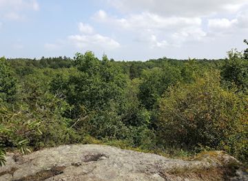
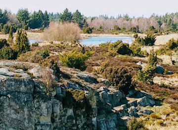
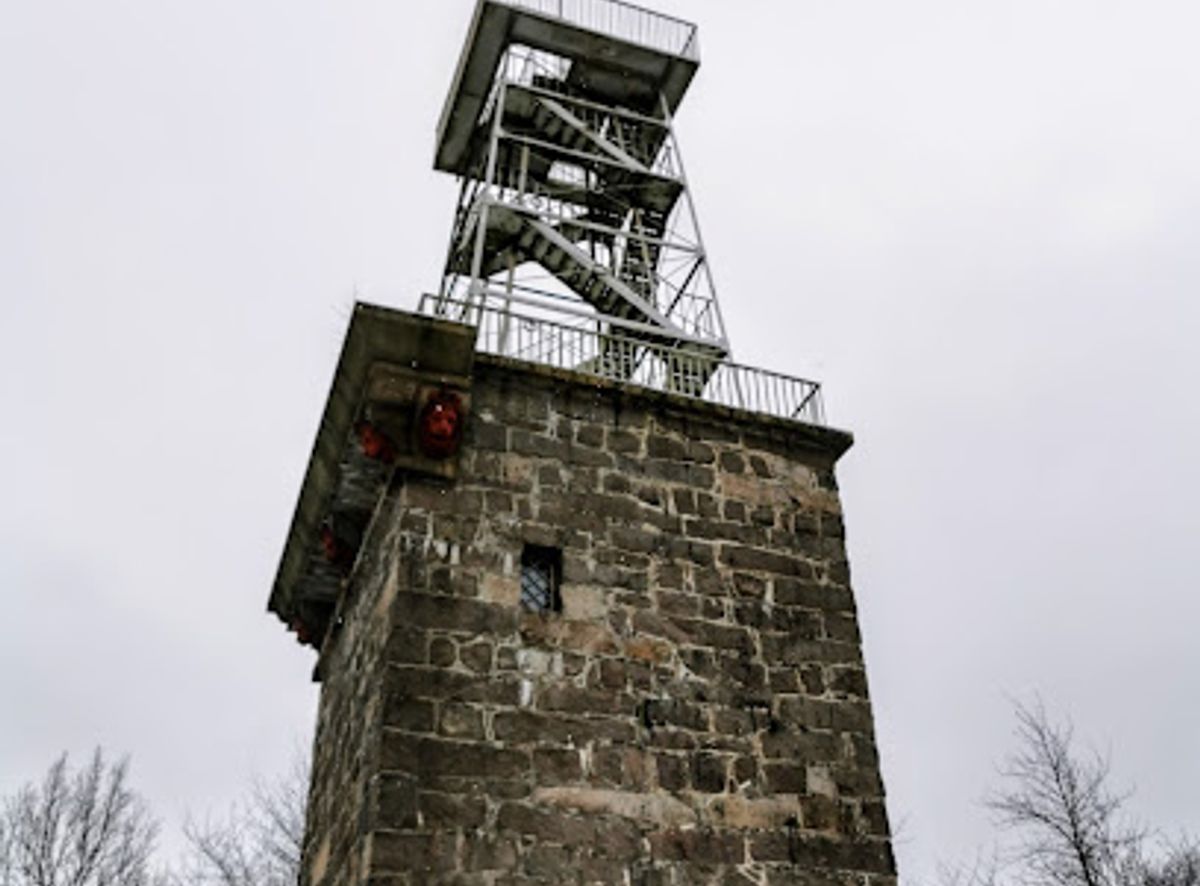
Bornholm’s Green Heart Reborn from Common Land
Almindingen stretches across the centre of Bornholm, forming one of Denmark’s largest continuous forest areas and the island’s verdant backbone. For centuries this plateau was shared pastureland rather than dense woodland, its name roughly meaning “the common” or “all men’s possession”. By around 1800, overgrazing and woodcutting had stripped most trees from the landscape. A royal decree launched a vast reforestation project, led by forester Hans Rømer. Stone walls were raised to keep grazing animals out, and new oaks, beeches and conifers were planted. Over the next two centuries Almindingen expanded dramatically as municipal plantations merged with the original forest. Today you wander through a man-made yet seemingly ancient landscape, where careful management blends commercial forestry with protected pockets of near-wild nature.Granite Cliffs, Rift Valleys and Quiet Forest Lakes
The character of Almindingen is shaped by Bornholm’s ancient granite bedrock. In many places it pushes through the thin soils as crags, boulders and rocky ground, giving the forest a distinctly Nordic feel. On the western side, steep rock walls and blocks line the trails, while hidden forest lakes and peat bogs lie tucked into hollows between low hills. Among the most striking features are Bornholm’s rift valleys. Ekkodalen, the longest, cuts a dramatic groove through the forest with cliffs up to 20 metres high and a famous natural echo bouncing off the stone. Elsewhere, small bogs and wetlands provide habitat for birds and dragonflies, best appreciated from simple wooden towers set beside reed-fringed pools. Even short walks here can take you from shady conifer stands to open heather, juniper thickets and mossy beech groves.Rytterknægten, Ancient Castles and Living History
In the middle of the forest rises Rytterknægten, at 162 metres the highest point on Bornholm. A tower and viewing platform crown the summit, offering broad views across the tree canopy and, in clear weather, towards the island’s coast. The monument here also commemorates a royal visit in the 19th century, tying the landscape to national history as well as local forestry efforts. Scattered through the woods are reminders of much earlier eras. The ruined fortresses of Gamleborg and Lilleborg sit on rocky knolls, once guarding routes across the island. From their crumbling walls you look out over tree-tops rather than medieval farmland, but the strategic siting remains easy to sense. Forest lanes lead to old ranger houses, an arboretum of tree species collected from similar latitudes, and sections of heath that preserve what Almindingen looked like before replanting, with juniper, birch and heather instead of tall timber.Bison, Birdlife and Subtle Wildlife Encounters
Almindingen’s varied habitats support rich flora and fauna, from fungi and lichens to songbirds, owls and raptors that hunt over clearings and marshes. Simple observation towers overlook lakes and bogs, giving you a quiet perch from which to scan for waterbirds and listen to the forest’s layered soundscape. In spring, wild garlic can carpet some valleys, while autumn brings intense colour and an abundance of mushrooms along the paths. A standout feature is the fenced bison enclosure, where a small herd of European bison – reintroduced here in the 21st century – graze within a large woodland paddock. Designated viewpoints allow you to look for these heavy, shaggy silhouettes among the trees. Sightings are never guaranteed, but the possibility adds a sense of wilderness unusual in Denmark. Red deer no longer roam freely as they once did, yet Almindingen still feels like an active, living ecosystem rather than a static park.Exploring on Foot, by Bike or on Horseback
The forest is laced with waymarked hiking trails of different lengths and difficulty levels, many of them themed routes linking viewpoints, lakes and historic sites. Broad forest roads and gentler paths suit family walks, while narrower tracks climb rocky slopes or wind along the base of rift valleys. Cyclists can follow gravel roads and designated routes, and there are specific bridle paths and paddocks for riders. Almindingen also caters to unhurried stays. Primitive campsites and simple shelters invite multi-day excursions, and picnic tables or clearings near lakes make natural lunch spots. Information boards in key areas explain geology, history and wildlife, helping you read the landscape as you go. Whether you come for a short stroll under the canopy, a full-day hike between valleys and viewpoints, or a quiet evening listening to birds over a forest bog, the experience is one of immersion in Bornholm’s reimagined wild core.Local tips
- Bring sturdy footwear and layers: trails range from smooth forest roads to rocky, rooty paths, and weather can shift quickly under the trees.
- Start early or late in the day for a better chance of spotting European bison and birdlife around lakes and clearings.
- Carry water and snacks; facilities are scattered and you can easily spend several hours between restrooms or cafes at the forest edges.
- Pick one focus area per visit—such as Ekkodalen, Rytterknægten, or the castle ruins—to avoid rushing across the large forest.
- If hiking with children, choose colour-marked shorter loops and consider pairing a walk with a picnic at a lake or viewpoint.
A brief summary to Almindingen
- Bornholm, DK
Getting There
-
Car from Rønne
Driving from Rønne to Almindingen takes around 20–30 minutes depending on your chosen trailhead, following the main inland roads across the island. Several free parking areas are available at key access points such as near Ekkodalen and Rytterknægten, but spaces can fill on sunny weekends and in July–August. Roads are paved and suitable for all standard vehicles, and there are no tolls or entrance fees for the forest itself.
-
Bus from Bornholm towns
Regional buses run between Rønne, Aakirkeby and other towns with stops along the main roads bordering Almindingen, with typical journey times of 20–40 minutes depending on departure point. From the nearest stops you should expect an additional walk on forest roads to reach specific sights such as Ekkodalen or the bison enclosure. Standard local bus fares apply and are generally a few tens of Danish kroner per adult; services are less frequent in the evening and outside the summer season.
-
Bicycle from Aakirkeby area
Cycling from Aakirkeby to Almindingen usually takes 20–35 minutes each way along a mix of minor roads and signposted cycle routes, with gentle but steady inclines as you approach the higher forest plateau. The route suits reasonably confident cyclists and older children; younger riders may find hills and traffic on some stretches more demanding. There is no charge to enter the forest, but bring lights and extra layers if returning in the cooler evening or shoulder seasons.