

Manaslu Circuit Travel Guide - Free Web & App
Your ultimate guide to Manaslu Circuit. Discover top landmarks, proposed trips, and local tips. Free on the web or via the Evendo companion app.


Manaslu Circuit Nepal crosses Himalayan valleys, Tibetan-influenced villages and Larkya La on a trek of mountain scenery, culture and high-altitude adventure.
A Remote Himalayan Traverse
The Manaslu Circuit is a demanding high-altitude trek around Mount Manaslu, the world's eighth-highest mountain, in north-central Nepal. The route follows the Budhi Gandaki valley from its lower foothills towards the Tibetan frontier before crossing the Larkya La, generally reached at about 5,100 metres, and descending towards the Marsyangdi valley. It links subtropical river gorges, pine and rhododendron forests, alpine pasture, glacial terrain and broad Himalayan panoramas within a single journey.Read more about Manaslu Circuit
Villages, Culture and Conservation
Planning the Trek
When is the best time to visit Manaslu Circuit?
Best: June–August · 22–24°C| Month | High (°C) | Rainfall (mm) |
|---|---|---|
| January | 1 | 30 |
| February | 2 | 30 |
| March | 5 | 30 |
| April | 12 | 30 |
| May | 17 | 30 |
| June (best) | 22 | 30 |
| July (best) | 24 | 30 |
| August (best) | 24 | 30 |
| September | 19 | 30 |
| October | 14 | 30 |
| November | 6 | 30 |
| December | 2 | 30 |
Getting to and around Manaslu Circuit
How to get there
Transportation
Best attractions in Manaslu Circuit
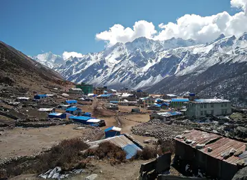
The Manaslu Circuit's principal attraction is the changing Budhi Gandaki valley, which rises from forested lower hills through narrow gorges and suspension bridges to the broad, dry landscapes around Samagaon and Samdo. The villages of Jagat, Deng, Namrung and Lho provide distinctive stages of the journey, with stone architecture, mani walls, chortens and mountain views shaping the experience. Samagaon is a natural base for seeing the upper Nubri valley and the surrounding peaks, while the walk towards Manaslu Base Camp offers a demanding high-altitude side excursion. The trail then climbs towards Dharamsala and the Larkya La, where the scenery becomes glacial and expansive before the descent towards Bimthang and the Marsyangdi valley. The neighbouring Tsum Valley, reached by a separate route and requiring additional arrangements, adds monasteries, traditional settlements and a strong Tibetan Buddhist character for trekkers extending their itinerary.
-
National reserve
Manaslu Trekking Area
Explore the breathtaking Manaslu Trekking Area in Nepal, where adventure meets cultural richness amidst stunning Himalayan landscapes.
-
Tourist attraction
Mu Gompa
Explore Mu Gompa: A Serene Buddhist Temple Nestled in the Majestic Himalayas, Ideal for Reflection and Spiritual Awakening.
-
Hiking area
Samagaun Hiking Area
Discover the unparalleled beauty and rich cultural heritage of the Samagaun Hiking Area, a premier destination for hiking and exploration in Nepal.
-
Hiking area
Manaslu Base Camp
Explore the breathtaking scenery and rich culture at Manaslu Base Camp, a premier hiking destination in the heart of the Himalayas.


Best landmarks in Manaslu Circuit
Mount Manaslu dominates the circuit's identity, rising above the upper Budhi Gandaki valley with glaciers, ridges and subsidiary peaks forming the backdrop to the trail. The Larkya La is the route's defining natural landmark: a high Himalayan pass linking the Budhi Gandaki and Marsyangdi drainage systems, with conditions that can be severe and views shaped by season and visibility. In the cultural landscape, Samagaon, Samdo, Lho and Namrung are distinguished by stone houses, chortens, mani walls and Buddhist monasteries associated with the Nubri region. The Budhi Gandaki itself is a continuing landmark, changing from a powerful lower river to a colder alpine watercourse. Forests, pasture and glacial terrain are protected within the Manaslu Conservation Area, whose ecological and cultural scope gives the route significance beyond its mountain viewpoints.
-
Mountain peak
Manaslu
Explore the breathtaking beauty of Manaslu, the eighth highest mountain in the world, and embark on an unforgettable trekking adventure in Nepal's majestic Himalayas.
-
National reserve
Manaslu Trekking Area
Discover the breathtaking beauty and rich culture of the Manaslu Trekking Area, a premier destination for adventure seekers in Nepal's majestic Himalayas.
-
Mountain pass
Larkya La Pass
Experience breathtaking views and rich cultural heritage at Larkya La Pass, a high-altitude gem in the heart of the Himalayas, Nepal.
-
Tourist attraction
Mu Gompa
Experience the tranquility of Mu Gompa, a stunning Buddhist temple nestled in the heart of the Himalayas, offering peace, culture, and breathtaking views.


Explore Manaslu Circuit on the map
Plan your trip on one map. See where the top attractions, landmarks, restaurants and hotels are, and book hotels and experiences in a few clicks.
Best hotels in Manaslu Circuit
Best restaurants in Manaslu Circuit
Dining on the Manaslu Circuit is centred on teahouses and small lodges rather than a conventional restaurant scene. Menus commonly draw on practical trekking food such as dal bhat, rice, noodles, soups, fried rice, momos, eggs, porridge and simple bakery items, with availability becoming more limited as the trail climbs. Dal bhat, usually served with rice, lentils and accompanying vegetables, is a staple across Nepal and provides a filling meal for long walking days. In the upper Nubri villages, Tibetan-influenced food traditions are evident in dishes such as thukpa and Tibetan-style breads, although menus vary by settlement and season. Machha Khola and lower gateway villages offer more choice than the high route, while trekkers should not expect extensive special-diet provision or dependable refrigeration. Carrying suitable snacks is sensible for the remote sections and pass crossing.
-
Restaurant
Hotel Ganga Manaslu and Resturant
Experience authentic Nepalese flavors at Hotel Ganga Manaslu and Restaurant, set against breathtaking Himalayan vistas.

Best bars in Manaslu Circuit
The Manaslu Circuit has no developed nightlife and should be approached as a trekking destination where evenings are quiet, early and shaped by mountain conditions. Teahouses in villages such as Jagat, Namrung, Samagaon and Dharapani may provide communal dining rooms where trekkers talk, read, play cards or share music, and some serve beer or locally available alcoholic drinks. Choices become more limited and prices generally reflect the difficulty of mountain supply as the route climbs. In the upper settlements, respectful conversation and an early rest are more characteristic than late entertainment, particularly before the Larkya La crossing. Kathmandu and larger gateway towns offer Nepal's broadest range of bars and evening venues, but those facilities are outside the Manaslu trekking area and should not be assumed to continue along the trail.
-
Restaurant
Hotel Ganga Manaslu and Resturant
Experience authentic Nepali cuisine with breathtaking mountain views at Hotel Ganga Manaslu and Restaurant, a must-visit on your Manaslu Trek.

Best shops in Manaslu Circuit
Shopping on the Manaslu Circuit is limited to practical trekking supplies and small locally made items rather than dedicated retail districts. Kathmandu and the larger roadhead settlements are the most reliable places to obtain clothing, equipment, medicines and snacks before the trek. Along the trail, teahouses and village shops may sell drinks, biscuits, noodles, batteries, basic toiletries and occasional handmade goods, but stock and opening arrangements vary. In the upper villages, visitors may encounter locally produced woollen items or small religious and craft objects, although these should be bought respectfully and not removed from active religious settings. Food products and textiles reflect the highland environment and Tibetan cultural connections, while porter and guide services are among the region's important forms of local employment. Carrying essential equipment from Kathmandu is more dependable than expecting to replace specialist gear en route.
-
 Ice Cream
Sylhet
Explore the flavors of Sylhet, where ice cream delights meet the picturesque landscapes of Nepal in a sweet travel experience.
Get your free copy of our complete guide to Manaslu Circuit, delivered straight to you.
Everything on this page, from attractions and restaurants to essentials and local phrases, in one PDF you can read offline, print or share.
Already have an account? Sign in
Your Manaslu Circuit guide is ready.
We'll send it to · Not you? Sign out

Getting your guide ready…
We are putting together a fresh copy of the Manaslu Circuit guide. This can take up to a minute.
This can take a few moments. If your browser asks, choose Allow so the download can start. You'll find the guide in your Downloads folder.
Nothing happened? Download it again
Sorry, the guide is taking longer than usual. Please try again in a minute, or get it by email instead.
Manaslu Circuit essentials
Currency and Payment
Safety
Emergency Situations
Do's and Don'ts
Local Tips
From Eve
Local phrases worth knowing
You don't need to get them perfect. A few words go a long way, and locals appreciate the effort.
Basics
| English | Local | Say it |
|---|---|---|
| Hello | नमस्ते | [namaste] |
| Goodbye | फेरी भेटौं | [feri bhetou] |
| Yes | हो | [ho] |
| No | होइन | [hoin] |
| Please/You're welcome | कृपया | [krupaya] |
| Thank you | धन्यवाद | [dhanyabad] |
| Excuse me/Sorry | माफ गर्नुहोस् | [maaf garnuhos] |
| How are you? | तपाईंलाई कस्तो छ? | [tapailai kasto cha?] |
| Fine. And you? | राम्रो छ। तपाईंलाई? | [ramro cha. tapailai?] |
| Do you speak English? | तपाईंले अंग्रेजी बोल्नुहुन्छ? | [tapainle angreji bolnuhunchha?] |
| I don't understand | मलाई सम्झिन्छैन | [malai samjhinchain] |
Eating & Drinking
| English | Local | Say it |
|---|---|---|
| I'd like to see the menu, please | कृपया मेनु हेर्न चाहन्छु | [krupaya menu hern chahanchu] |
| I don't eat meat | म भांसास खाइन | [ma bhaansaas khain] |
| Cheers! | चियर्स! | [cheers!] |
| I would like to pay, please | कृपया भुक्तानी गर्न चाहन्छु | [krupaya bhuktani garn chahanchu] |
Emergencies
| English | Local | Say it |
|---|---|---|
| Help! | मद्दत गर्नुहोस्! | [maddat garnuhos!] |
| Go away! | टाढा जानुहोस्! | [tadha januhos!] |
| Call the Police! | पुलिसलाई बोलाउनुहोस्! | [poliselai bolaunuhos!] |
| Call a doctor! | डाक्टरलाई बोलाउनुहोस्! | [daktarlai bolaunuhos!] |
| I'm lost | म कहिल्यै गुमाइएको छु | [ma kahilyai gumaieko chu] |
| I'm ill | म अस्वस्थ छु | [ma aswastha chu] |
Shopping
| English | Local | Say it |
|---|---|---|
| I'd like to buy... | म खरिद गर्न चाहन्छु... | [ma kharid garn chahanchu...] |
| I'm just looking | म सिर्जना गर्न आएको छु | [ma sirjana garn aeko chu] |
| How much is it? | यो कति हो? | [yo kati ho?] |
| That's too expensive | यो धेरै महँगो छ | [yo dherai mahango cha] |
| Can you lower the price? | के तपाईं मूल्य हाल्न सक्नुहुन्छ? | [ke tapain mulya haln saknuhunchha?] |
Time & Numbers
| English | Local | Say it |
|---|---|---|
| What time is it? | कति बज्यो? | [kati bajyo?] |
| It's one o'clock | एक बज्यो | [ek bajyo] |
| Half past (10) | दस बजे अघि | [das baje agi] |
| Morning | बिहान | [bihan] |
| Afternoon | दिउँसो | [diunso] |
| Evening | साँझ | [sanh] |
| Yesterday | हिजो | [hijo] |
| Today | आज | [aaj] |
| Tomorrow | भोलि | [bholi] |
| 1 | एक | [ek] |
| 2 | दुई | [dui] |
| 3 | तीन | [tin] |
| 4 | चार | [char] |
| 5 | पाँच | [paanch] |
| 6 | छ | [chha] |
| 7 | सात | [saat] |
| 8 | आठ | [aath] |
| 9 | नौ | [nau] |
| 10 | दश | [dash] |
Transport & Directions
| English | Local | Say it |
|---|---|---|
| Where's a/the...? | ...... कहाँ छ? | [...... kaha chha?] |
| What's the address? | ठेगाना के हो? | [thegana ke ho?] |
| Can you show me (on the map)? | के तपाईंले मलाई देखाउन सक्नुहुन्छ? | [ke tapainle malai dekhaun saknuhunchha?] |
| When's the next (bus)? | अर्को (बस) कहिले छ? | [arko (bas) kahile chha?] |
| A ticket (to ....) | एक टिकट (....... लागि) | [ek ticket (....... lagi)] |
History of Manaslu Circuit
A Young Himalayan Mountain Landscape
The Manaslu region was shaped by the collision of the Indian and Eurasian tectonic plates, which raised the Himalaya and continue to influence its steep valleys, active geology and high peaks. The Budhi Gandaki cuts a notably varied route through the landscape, descending from glaciated mountain terrain towards warmer middle hills. For visitors, this geological structure explains the circuit's rapid succession of ecological zones, from humid river conditions and forest to alpine pasture and the snowbound surroundings of Larkya La.
Gorkha and the Budhi Gandaki Corridor
The lower approach to Manaslu lies within the wider historical sphere of Gorkha, a hill region closely associated with the formation of the modern state of Nepal. Farther north, the Budhi Gandaki corridor connected communities in the middle hills with high valleys bordering Tibet. Trade, animal movement, seasonal herding and religious exchange shaped settlements along the route, although the circuit was not historically a single formal trekking trail. Local communities developed distinctive customs in response to altitude, terrain and their position between central Nepal and the Tibetan cultural world.
Highland Buddhist Communities
In the upper valley, particularly around Namrung, Lho, Samagaon and Samdo, architecture and religious life reflect long-standing Himalayan Buddhist traditions. Monasteries, chortens, mani walls and prayer flags remain visible expressions of this heritage, while agricultural and pastoral practices have been adapted to a short growing season. Samagaon is an important settlement in the Nubri area, and its surrounding monasteries and landscapes illustrate the relationship between Buddhist culture, trans-Himalayan trade and high-altitude livelihoods.
Conservation and the Opening of Trekking
The Manaslu Conservation Area was established in 1998 to combine protection of an ecologically diverse mountain environment with community participation in local development. Trekking gradually expanded as access improved and the region became better known for its combination of wilderness, cultural landscapes and a challenging high pass. Because the area includes a restricted frontier zone, visitor numbers and access arrangements have traditionally been managed more closely than on many commercial trekking routes. Tourism income now supports teahouses, guides, porters and other services while conservation remains central to the region's future.
Manaslu Circuit in Photos
Browse through our photo collection highlighting the charm and character of the destination.
Neighbouring destination travel guides
The closest destinations to Manaslu Circuit, if you have time for more than one.
-

-
-

-

-


Swipe for more destinations
Explore more

Explore more of Gandaki Zone
Explore Gandaki Zone from Pokhara’s lakes and Annapurna trails to Gorkha heritage, high Manang valleys and Nepal’s diverse hill cultures.
Explore Gandaki Zone
Explore more of Nepal
Discover Nepal: A land of towering peaks, spiritual harmony, and vibrant culture, offering endless adventures and serene escapes for every traveler.
Explore Nepal