

Fire Island Travel Guide - Free Web & App
Your ultimate guide to Fire Island. Discover top landmarks, proposed trips, and local tips. Free on the web or via the Evendo companion app.


Fire Island, New York, pairs Atlantic beaches, dunes, maritime forest, LGBTQ+ heritage, the Fire Island Lighthouse and car-free seaside communities.
A Barrier Island Between Ocean and Bay
Fire Island stretches along the south shore of Long Island, New York, as a narrow barrier island separating the Atlantic Ocean from Great South Bay. Its sandy beaches, shifting dunes, maritime forests and salt-marsh edges form a landscape shaped by wind, tides and storms. Much of the island lies within Fire Island National Seashore, while Fire Island State Park occupies the western end. There is no single town or conventional centre: instead, a chain of predominantly seasonal communities is linked by ferries, water taxis, boardwalks and sandy lanes.Read more about Fire Island
Beaches, Dunes and Maritime Forest
Villages with Distinctive Character
When is the best time to visit Fire Island?
Best: June, August–September · 23–27°C| Month | High (°C) | Rainfall (mm) |
|---|---|---|
| January | 4 | 79 |
| February | 4 | 74 |
| March | 9 | 96 |
| April | 14 | 94 |
| May | 19 | 104 |
| June (best) | 24 | 89 |
| July | 27 | 100 |
| August (best) | 27 | 104 |
| September (best) | 23 | 95 |
| October | 17 | 94 |
| November | 11 | 89 |
| December | 6 | 95 |
Getting to and around Fire Island
How to get there
Transportation
Best attractions in Fire Island
Fire Island's principal attraction is its Atlantic shoreline, where wide sand beaches, rolling surf and shifting dunes provide the setting for swimming where conditions permit, walking and wildlife observation. Fire Island National Seashore protects much of the island's natural landscape, including maritime forest, salt marsh and the Fire Island Wilderness at the eastern end. At the west, the Fire Island Lighthouse offers a historic focus near the Robert Moses State Park approach, while nearby communities such as Kismet and Saltaire provide contrasting village atmospheres. Ocean Beach combines beach access with the island's largest concentration of shops, cafés and restaurants. Cherry Grove and The Pines are notable for their LGBTQ+ cultural heritage and seasonal community life. Other hamlets, including Fair Harbor, Ocean Bay Park and Davis Park, are best experienced through their quieter boardwalks, bayfront settings and proximity to the ocean rather than through conventional sightseeing itineraries.
-
State park
Heckscher State Park
Explore Heckscher State Park, a serene retreat in East Islip, NY, offering scenic landscapes, outdoor activities, and beautiful views of the Great South Bay.
-
Visitor center
Sailors Haven Visitor Center
Discover the natural beauty and rich history of Fire Island at Sailors Haven Visitor Center, your gateway to adventure and exploration.
-
Woods
Sunken Forest
Discover the serene beauty of Sunken Forest in Fire Island, NY, where nature trails and lush woodlands await every nature enthusiast.
-
Beach
Sailors Haven
Experience the serene beauty of Sailors Haven, a tranquil beach retreat on Fire Island, perfect for relaxation and outdoor adventures.


Best landmarks in Fire Island
The Fire Island Lighthouse is the island's most recognisable built landmark, a nineteenth-century navigational tower near the western end whose position reflects the hazards and importance of Long Island's Atlantic approaches. The island's natural landmarks are equally significant: its ocean beach, high dunes, maritime forest and bay-side wetlands demonstrate the shifting structure of a barrier island. The Fire Island Wilderness preserves a particularly undeveloped eastern landscape, where the absence of roads and dense construction allows visitors to experience the island's coastal processes more directly. The communities themselves, especially Cherry Grove and The Pines, are cultural landmarks through their association with LGBTQ+ history and seasonal social life. Robert Moses State Park and Smith Point County Park serve as important mainland-access gateways at opposite ends, but they are distinct from the protected and residential landscapes along the central island.
-
Woods
Sunken Forest
Explore the tranquil beauty of Sunken Forest on Fire Island, a serene escape into nature's untouched wilderness.

Explore Fire Island on the map
Plan your trip on one map. See where the top attractions, landmarks, restaurants and hotels are, and book hotels and experiences in a few clicks.
Best hotels in Fire Island
Best restaurants in Fire Island
Dining on Fire Island is concentrated in the seasonal communities rather than scattered through the protected landscape. Ocean Beach has the broadest range of restaurants, cafés, delis, ice-cream shops and provisions, while smaller villages generally offer a more limited selection of casual eateries, markets or community-based seasonal businesses. Menus commonly reflect the island's coastal setting through seafood, salads, sandwiches and relaxed summer fare, alongside familiar American dishes and drinks. Restaurants and shops in Cherry Grove, The Pines, Kismet and other ferry-served communities contribute to distinctive local social scenes, although the choice and opening pattern can change outside the main season. Visitors staying in houses or cottages often supplement eating out with provisions brought from the mainland, particularly when travelling to quieter communities or the eastern wilderness, where there are no conventional dining facilities.
-
 Hotel
Fire Island Beach House
Experience coastal bliss at Fire Island Beach House - where relaxation meets vibrant beach life in Ocean Bay Park.
-
Pizza
Pizza Shack of Kismet
Experience the best New York-style pizza at Pizza Shack of Kismet on Fire Island - where delicious food meets stunning waterfront views.
-
Bistro
Pines Bistro
Discover the charm and flavors of Fire Island at Pines Bistro – your go-to destination for exquisite dining experiences.


Best bars in Fire Island
Fire Island's evening life is concentrated in its summer communities and is generally social, informal and seasonal rather than city-like. Ocean Beach has the largest cluster of bars and evening venues, with restaurants and waterfront settings contributing to a relaxed after-dark atmosphere. Cherry Grove and The Pines are particularly well known for LGBTQ+ nightlife, community events and a long tradition of welcoming summer visitors, while smaller settlements tend to centre on village bars, restaurants and private gatherings. Entertainment can include music, dancing and seasonal celebrations, but schedules and venue availability vary considerably. There is no continuous nightlife district across the island, and quieter communities may become very calm after dinner. Visitors should plan the last ferry or water-taxi connection carefully if spending the evening away from their accommodation base.
-
American
Maguire's Bayfront Restaurant
Experience the best of American cuisine at Maguire's Bayfront Restaurant, where breathtaking views meet delicious seafood and grill favorites.
-
Dance restaurant
Cherry's On The Bay
Discover the lively atmosphere of Cherry's On The Bay, where exquisite dining meets electrifying nightlife in Cherry Grove.
-
Bar
Island Mermaid
Experience the flavors of the coast at Island Mermaid, a vibrant bar and restaurant in Ocean Beach offering seafood delights and a lively atmosphere.
-
Restaurant
Flynn's Fire Island
Experience the best of coastal dining at Flynn's Fire Island, where delicious cuisine meets stunning marina views in Ocean Bay Park.


Best nightclubs in Fire Island
Fire Island's evening life is concentrated in its summer communities and is generally social, informal and seasonal rather than city-like. Ocean Beach has the largest cluster of bars and evening venues, with restaurants and waterfront settings contributing to a relaxed after-dark atmosphere. Cherry Grove and The Pines are particularly well known for LGBTQ+ nightlife, community events and a long tradition of welcoming summer visitors, while smaller settlements tend to centre on village bars, restaurants and private gatherings. Entertainment can include music, dancing and seasonal celebrations, but schedules and venue availability vary considerably. There is no continuous nightlife district across the island, and quieter communities may become very calm after dinner. Visitors should plan the last ferry or water-taxi connection carefully if spending the evening away from their accommodation base.
-
Night club
Sip·n·Twirl
Experience the vibrant nightlife at Sip·n·Twirl, a popular night club and gay bar in Fire Island Pines, perfect for dancing and socializing.
-
Gay bar
Pavilion
Experience the vibrant nightlife at Pavilion, Fire Island Pines' premier gay bar, where joy, music, and inclusivity create unforgettable memories.


Best shops in Fire Island
Shopping on Fire Island is practical and seasonal, with the greatest concentration in Ocean Beach and smaller selections in communities such as Cherry Grove, The Pines and Kismet. Visitors can find beach goods, clothing, gifts, provisions, books, refreshments and locally themed souvenirs, while galleries and independent businesses may offer art or craft items during the main season. The island is not a conventional retail destination, and many visitors bring substantial supplies from Long Island before boarding the ferry, particularly when staying in a quieter hamlet. Outdoor and beach equipment is available only where local seasonal businesses stock it, so specialist requirements are better handled on the mainland. Shopping opportunities, opening patterns and product ranges can contract sharply outside the summer period.
-
American
RACHEL’S Restaurant & Bakery
Experience the best of American cuisine and freshly baked goods at Rachel's Restaurant & Bakery in Ocean Beach, NY.
-
Grocery store
Seaview Market
Discover fresh produce and local delights at Seaview Market, your go-to grocery store in Ocean Beach, New York.
-
Grocery store
Pines Pantry
Explore the flavors of Fire Island at Pines Pantry, your go-to grocery store for local produce, baked goods, and artisanal delights.
-
Wine store
The Pines Liquor Shop
Experience the charm of Fire Island Pines at The Pines Liquor Shop, your go-to destination for fine wines and a vibrant social scene.


Get your free copy of our complete guide to Fire Island, delivered straight to you.
Everything on this page, from attractions and restaurants to essentials and local phrases, in one PDF you can read offline, print or share.
Already have an account? Sign in
Your Fire Island guide is ready.
We'll send it to · Not you? Sign out

Getting your guide ready…
We are putting together a fresh copy of the Fire Island guide. This can take up to a minute.
This can take a few moments. If your browser asks, choose Allow so the download can start. You'll find the guide in your Downloads folder.
Nothing happened? Download it again
Sorry, the guide is taking longer than usual. Please try again in a minute, or get it by email instead.
Fire Island essentials
Currency and Payment
Safety
Emergency Situations
Do's and Don'ts
Local Tips
From Eve
Local phrases worth knowing
You don't need to get them perfect. A few words go a long way, and locals appreciate the effort.
Basics
| English | Local | Say it |
|---|---|---|
| Hello | Hey | [Hey] |
| Goodbye | Later | [Lay-ter] |
| Yes | Yeah | [Yeah] |
| No | Nope | [Noh-p] |
| Please/You're welcome | Please | [Pleez] |
| Thank you | Thanks | [Th-anks] |
| Excuse me/Sorry | Sorry | [Sor-ee] |
| How are you? | How you doin'? | [How yuh doin'] |
| Fine. And you? | I'm good. You? | [I'm good. You?] |
| Do you speak English? | You speak English? | [Yuh speak English?] |
| I don't understand | I don't get it | [I don't get it] |
Eating & Drinking
| English | Local | Say it |
|---|---|---|
| I'd like to see the menu, please | Menu, please | [Menu, please] |
| I don't eat meat | No meat for me | [No meat for me] |
| Cheers! | Cheers! | [Cheers!] |
| I would like to pay, please | Check, please | [Check, please] |
Emergencies
| English | Local | Say it |
|---|---|---|
| Help! | Help! | [Help!] |
| Go away! | Go away! | [Go away!] |
| Call the Police! | Call the cops! | [Call the cops!] |
| Call a doctor! | Get a doc! | [Get a doc!] |
| I'm lost | Lost | [Lost] |
| I'm ill | Sick | [Sick] |
Shopping
| English | Local | Say it |
|---|---|---|
| I'd like to buy... | I wanna buy... | [I wanna buy...] |
| I'm just looking | Just looking | [Just looking] |
| How much is it? | How much? | [How much?] |
| That's too expensive | Too pricey | [Too pricey] |
| Can you lower the price? | Discount? | [Discount?] |
Time & Numbers
| English | Local | Say it |
|---|---|---|
| What time is it? | What time? | [What time?] |
| It's one o'clock | It's one | [It's one] |
| Half past (10) | Ten thirty | [Ten thur-tee] |
| Morning | Morning | [Morning] |
| Afternoon | Afternoon | [Afternoon] |
| Evening | Evening | [Evening] |
| Yesterday | Yesterday | [Yesterday] |
| Today | Today | [Today] |
| Tomorrow | Tomorrow | [Tomorrow] |
| 1 | One | [One] |
| 2 | Two | [Two] |
| 3 | Three | [Three] |
| 4 | Four | [Four] |
| 5 | Five | [Five] |
| 6 | Six | [Six] |
| 7 | Seven | [Seven] |
| 8 | Eight | [Eight] |
| 9 | Nine | [Nine] |
| 10 | Ten | [Ten] |
Transport & Directions
| English | Local | Say it |
|---|---|---|
| Where's a/the...? | Where's the...? | [Where's the...?] |
| What's the address? | Address? | [Address?] |
| Can you show me (on the map)? | Show me the way? | [Show me the way?] |
| When's the next (bus)? | Next bus? | [Next bus?] |
| A ticket (to ....) | Ticket (to ...) | [Ticket (to ...)] |
History of Fire Island
An Older Island Landscape
Fire Island forms part of the barrier-island system along Long Island's south shore, created and continually reshaped by waves, currents, storms and the movement of sand. Before European settlement, the surrounding region was used by Indigenous peoples, including communities associated with the Secatogue and Unkechaug peoples. The island's position between the Atlantic and Great South Bay made it part of a wider coastal environment of beaches, dunes, marshes, shellfish grounds and fishing waters rather than a densely settled inland landscape.
Names, Settlement and Coastal Use
European maps and records gradually incorporated the island into the colonial landscape of Long Island. The origin of the name Fire Island is disputed; explanations have included Indigenous signalling fires, fires used by shipwreck survivors and navigational references, but no single interpretation is universally accepted. For centuries, the island and nearby bays supported fishing, hunting, shellfishing and other forms of coastal use. Permanent settlement remained limited because the barrier shore was exposed to storms and difficult to reach overland.
The Lighthouse and Maritime Navigation
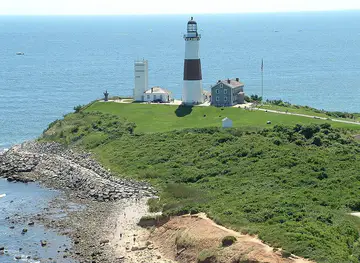
The Fire Island Lighthouse was built in 1858 to improve navigation at the western entrance to New York Harbour approaches and the waters off Long Island. Its tall tower became an important landmark for ships and a visual reference for arriving visitors. The lighthouse stands near the western end of the island, close to the present-day Robert Moses State Park, and replaced an earlier lighthouse constructed in 1826. Its continued preservation reflects Fire Island's long connection with maritime travel, shipwreck risk and coastal navigation.
Resorts and Distinctive Communities
Improved ferry connections and the growth of leisure travel brought a stronger resort identity during the late nineteenth and twentieth centuries. Villages developed with summer houses, guest accommodation, shops and social institutions rather than conventional urban street plans. Cherry Grove became especially associated with LGBTQ+ life and culture, while neighbouring communities developed their own seasonal traditions. The island's relative separation from Long Island encouraged an atmosphere shaped by walking, bicycles, beach access and community life, even as tourism expanded.
National Seashore and Conservation
Fire Island National Seashore was established in 1964 to protect a substantial portion of the island's beaches, dunes, maritime forests, wetlands and historic places while allowing established communities to remain. Conservation work has had to balance public recreation, private development, storm damage, erosion and the natural movement of a barrier island. The Wilderness area at the eastern end preserves one of the least developed sections. Today, the island's character depends on managing visitation and construction in a landscape that remains physically changeable rather than fixed.
Fire Island in Photos
Browse through our photo collection highlighting the charm and character of the destination.
Neighbouring destination travel guides
The closest destinations to Fire Island, if you have time for more than one.
-

-

-
-

-


Swipe for more destinations
Explore more

Explore more of Long Island
Discover Long Island: A blend of pristine beaches, historic mansions, vibrant arts, and exquisite culinary experiences just a short trip from New York City.
Explore Long Island
Explore more of New York
Discover the electrifying energy, iconic landmarks, and diverse cultural experiences of New York City, the ultimate urban playground for travelers from around the world.
Explore New York